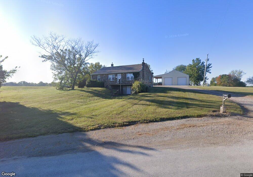
43 NE 641 Knob Noster, MO 65336
Estimated Value: $210,414 - $335,000
--
Bed
--
Bath
1,494
Sq Ft
$169/Sq Ft
Est. Value
About This Home
This home is located at 43 NE 641, Knob Noster, MO 65336 and is currently estimated at $252,805, approximately $169 per square foot. 43 NE 641 is a home located in Johnson County with nearby schools including Knob Noster High School.
Ownership History
Date
Name
Owned For
Owner Type
Purchase Details
Closed on
Sep 7, 2022
Sold by
Owens Taylor Don and Brooke Lauren
Bought by
Owens Taylor Don and Owens Brooke Lauren
Current Estimated Value
Home Financials for this Owner
Home Financials are based on the most recent Mortgage that was taken out on this home.
Original Mortgage
$162,800
Outstanding Balance
$155,598
Interest Rate
5.3%
Mortgage Type
FHA
Estimated Equity
$97,207
Purchase Details
Closed on
Feb 18, 2015
Sold by
Wickham Doug and Wickham Lisa
Bought by
Owens Taylor
Home Financials for this Owner
Home Financials are based on the most recent Mortgage that was taken out on this home.
Original Mortgage
$90,000
Interest Rate
3.78%
Mortgage Type
Future Advance Clause Open End Mortgage
Create a Home Valuation Report for This Property
The Home Valuation Report is an in-depth analysis detailing your home's value as well as a comparison with similar homes in the area
Home Values in the Area
Average Home Value in this Area
Purchase History
| Date | Buyer | Sale Price | Title Company |
|---|---|---|---|
| Owens Taylor Don | -- | Truman Title | |
| Owens Taylor | -- | None Available |
Source: Public Records
Mortgage History
| Date | Status | Borrower | Loan Amount |
|---|---|---|---|
| Open | Owens Taylor Don | $162,800 | |
| Previous Owner | Owens Taylor | $90,000 |
Source: Public Records
Tax History Compared to Growth
Tax History
| Year | Tax Paid | Tax Assessment Tax Assessment Total Assessment is a certain percentage of the fair market value that is determined by local assessors to be the total taxable value of land and additions on the property. | Land | Improvement |
|---|---|---|---|---|
| 2024 | $449 | $8,145 | $0 | $0 |
| 2023 | $449 | $6,053 | $0 | $0 |
| 2022 | $323 | $5,847 | $0 | $0 |
| 2021 | $321 | $5,847 | $0 | $0 |
| 2020 | $316 | $5,641 | $0 | $0 |
| 2019 | $303 | $5,641 | $0 | $0 |
| 2017 | $280 | $5,641 | $0 | $0 |
| 2016 | $281 | $5,641 | $0 | $0 |
| 2015 | $251 | $5,641 | $0 | $0 |
| 2014 | $249 | $4,662 | $0 | $0 |
Source: Public Records
Map
Nearby Homes
- 125 NE 641st Rd
- 137 SE 611th Rd
- 463 SE 90th Rd
- 80 SE 451st Rd
- 109 SE 421st Rd
- 628 SE 150th St
- 122 SE 411th Rd
- 604 Angus Ln
- 1604 W 6th Street Terrace
- 176 SE 431st Rd
- 174 SE 421st Rd
- 1700 W 6th Street Terrace
- 170 SE 411th Rd
- 365 SE 85th Rd
- 606 Kendrick St
- 84 SE 351st Rd
- 609 Summit Rd
- 611 Summit Rd
- 900 Summit Rd
- 501 W Mcpherson St