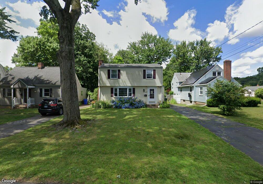
43 Park Ave Wethersfield, CT 06109
Estimated Value: $368,349 - $395,000
3
Beds
2
Baths
1,470
Sq Ft
$260/Sq Ft
Est. Value
About This Home
This home is located at 43 Park Ave, Wethersfield, CT 06109 and is currently estimated at $382,337, approximately $260 per square foot. 43 Park Ave is a home located in Hartford County with nearby schools including Charles Wright School, Silas Deane Middle School, and Wethersfield High School.
Ownership History
Date
Name
Owned For
Owner Type
Purchase Details
Closed on
Nov 26, 2018
Sold by
Adams John
Bought by
Adams Jennifer
Current Estimated Value
Purchase Details
Closed on
Sep 12, 2005
Sold by
Niland Jay T
Bought by
Adams John and Adams Jennifer
Home Financials for this Owner
Home Financials are based on the most recent Mortgage that was taken out on this home.
Original Mortgage
$187,920
Interest Rate
5.79%
Purchase Details
Closed on
Jan 31, 1992
Sold by
Savoca Carmine
Bought by
Miland Jay T
Home Financials for this Owner
Home Financials are based on the most recent Mortgage that was taken out on this home.
Original Mortgage
$98,400
Interest Rate
5.99%
Purchase Details
Closed on
Oct 27, 1987
Sold by
Kaminski Francis
Bought by
Howe Grace C
Create a Home Valuation Report for This Property
The Home Valuation Report is an in-depth analysis detailing your home's value as well as a comparison with similar homes in the area
Home Values in the Area
Average Home Value in this Area
Purchase History
| Date | Buyer | Sale Price | Title Company |
|---|---|---|---|
| Adams Jennifer | -- | -- | |
| Adams Jennifer | -- | -- | |
| Adams John | $234,900 | -- | |
| Miland Jay T | $123,000 | -- | |
| Howe Grace C | $159,900 | -- |
Source: Public Records
Mortgage History
| Date | Status | Borrower | Loan Amount |
|---|---|---|---|
| Previous Owner | Howe Grace C | $187,920 | |
| Previous Owner | Howe Grace C | $46,980 | |
| Previous Owner | Howe Grace C | $98,400 |
Source: Public Records
Tax History
| Year | Tax Paid | Tax Assessment Tax Assessment Total Assessment is a certain percentage of the fair market value that is determined by local assessors to be the total taxable value of land and additions on the property. | Land | Improvement |
|---|---|---|---|---|
| 2025 | $8,836 | $214,370 | $68,540 | $145,830 |
| 2024 | $6,447 | $149,170 | $63,760 | $85,410 |
| 2023 | $6,232 | $149,170 | $63,760 | $85,410 |
| 2022 | $6,128 | $149,170 | $63,760 | $85,410 |
| 2021 | $6,067 | $149,170 | $63,760 | $85,410 |
| 2020 | $6,070 | $149,170 | $63,760 | $85,410 |
| 2019 | $6,077 | $149,170 | $63,760 | $85,410 |
| 2018 | $5,958 | $146,100 | $60,700 | $85,400 |
| 2017 | $5,810 | $146,100 | $60,700 | $85,400 |
| 2016 | $5,631 | $146,100 | $60,700 | $85,400 |
| 2015 | $5,580 | $146,100 | $60,700 | $85,400 |
| 2014 | $5,368 | $146,100 | $60,700 | $85,400 |
Source: Public Records
Map
Nearby Homes
- 192 Wolcott Hill Rd
- 219-221 Jordan Ln
- 23 Hillcrest Ave
- 18 Avalon Place
- 107 Harmund Place
- 55 Rutledge Rd
- 1 Brussels Ave
- 19 Albert Ave
- 1 Bristol St
- 317-319 Garden St
- 1 Fernwood St
- 144 Brown St
- 64 Cromwell St
- 28 Bolton St
- 295 Ridge Rd Unit 8
- 51 Hanmer St
- 63 Wells Farm Dr
- 166 George St
- 493 Main St
- 35 Stillwold Dr
Your Personal Tour Guide
Ask me questions while you tour the home.