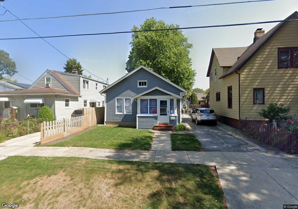
43 S Maple Ave Waukegan, IL 60085
West Waukegan NeighborhoodEstimated Value: $132,000 - $200,000
2
Beds
1
Bath
700
Sq Ft
$241/Sq Ft
Est. Value
About This Home
This home is located at 43 S Maple Ave, Waukegan, IL 60085 and is currently estimated at $168,978, approximately $241 per square foot. 43 S Maple Ave is a home located in Lake County with nearby schools including Washington Elementary School, Robert E. Abbott Middle School, and Waukegan High School.
Ownership History
Date
Name
Owned For
Owner Type
Purchase Details
Closed on
Apr 30, 2024
Sold by
William A Carlsen Living Trust and Howe Holly
Bought by
Thackston Samantha
Current Estimated Value
Purchase Details
Closed on
Aug 29, 2023
Sold by
William Carlsen Property Trust and Carlsen William
Bought by
William L Carlsen Living Trust and Carlsen
Purchase Details
Closed on
Aug 1, 2022
Sold by
Carlsen William
Bought by
William Carlsen Property Trust and Carlsen
Purchase Details
Closed on
Oct 6, 1998
Sold by
Larsen Anna B
Bought by
Carlsen William L
Create a Home Valuation Report for This Property
The Home Valuation Report is an in-depth analysis detailing your home's value as well as a comparison with similar homes in the area
Home Values in the Area
Average Home Value in this Area
Purchase History
| Date | Buyer | Sale Price | Title Company |
|---|---|---|---|
| Thackston Samantha | -- | None Listed On Document | |
| William L Carlsen Living Trust | -- | None Listed On Document | |
| William Carlsen Property Trust | -- | Orourke Kevin B | |
| Carlsen William L | -- | -- |
Source: Public Records
Tax History
| Year | Tax Paid | Tax Assessment Tax Assessment Total Assessment is a certain percentage of the fair market value that is determined by local assessors to be the total taxable value of land and additions on the property. | Land | Improvement |
|---|---|---|---|---|
| 2024 | $2,824 | $33,476 | $6,108 | $27,368 |
| 2023 | $2,588 | $29,945 | $5,464 | $24,481 |
| 2022 | $2,588 | $26,478 | $4,851 | $21,627 |
| 2021 | $2,311 | $22,170 | $4,172 | $17,998 |
| 2020 | $2,341 | $20,654 | $3,887 | $16,767 |
| 2019 | $2,356 | $18,926 | $3,562 | $15,364 |
| 2018 | $2,101 | $16,253 | $5,546 | $10,707 |
| 2017 | $2,046 | $14,380 | $4,907 | $9,473 |
| 2016 | $1,931 | $12,496 | $4,264 | $8,232 |
| 2015 | $1,889 | $11,184 | $3,816 | $7,368 |
| 2014 | $2,188 | $12,926 | $4,089 | $8,837 |
| 2012 | $2,977 | $14,004 | $4,430 | $9,574 |
Source: Public Records
Map
Nearby Homes
- 108 Dorchester Ct
- 52 Wisconsin Ave
- 714 Glen Rock Ave
- 1820 Jenkinson Ct
- 417 S Lewis Ave
- 446 S Jackson St
- 317 N Jackson St
- 1124 Jackson Ct
- 305 Besley Place
- 613 Clarke Ave
- 10 N Park Ave
- 557 W Water St
- 205 S Park Ave
- 2209 Melrose Ave
- 505 Lorraine Ave
- 610 S Fulton Ave
- 502 Belvidere Rd
- 619 N Butrick St
- 511 Chestnut St
- 1213 Washington Park
- 41 S Maple Ave
- 45 S Maple Ave
- 35 S Maple Ave
- 1414 Catalpa St
- 1418 Catalpa St
- 31 S Maple Ave
- 42 S Butrick St
- 46 S Butrick St
- 40 S Butrick St
- 50 S Butrick St
- 34 S Butrick St
- 44 S Maple Ave
- 1504 Catalpa St
- 54 S Butrick St
- 46 S Maple Ave
- 40 S Maple Ave
- 38 S Maple Ave
- 30 S Butrick St
- 34 S Maple Ave
- 25 S Maple Ave
Your Personal Tour Guide
Ask me questions while you tour the home.