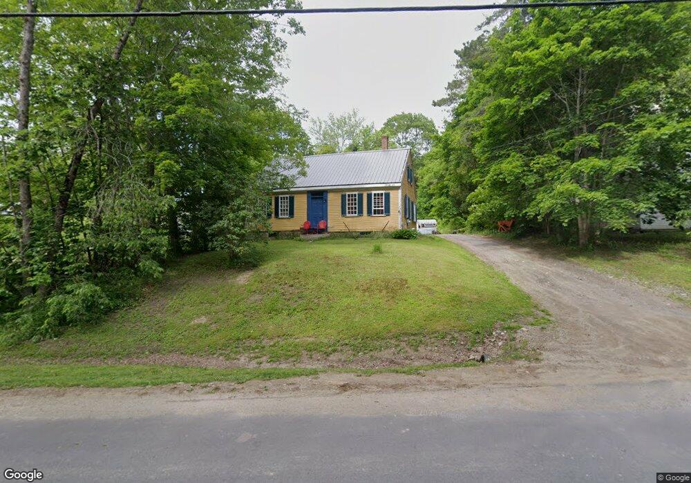
43 Union St Warren, ME 04864
Estimated Value: $327,000 - $397,000
2
Beds
1
Bath
1,500
Sq Ft
$243/Sq Ft
Est. Value
About This Home
This home is located at 43 Union St, Warren, ME 04864 and is currently estimated at $364,064, approximately $242 per square foot. 43 Union St is a home located in Knox County with nearby schools including Medomak Valley High School.
Ownership History
Date
Name
Owned For
Owner Type
Purchase Details
Closed on
Oct 8, 2010
Sold by
Isaac Carol K
Bought by
Citimortgage Inc
Current Estimated Value
Purchase Details
Closed on
Jan 24, 2007
Sold by
Rocray David Kimball and Lewis Mary Heather
Bought by
Isaac Carol K
Home Financials for this Owner
Home Financials are based on the most recent Mortgage that was taken out on this home.
Original Mortgage
$144,800
Interest Rate
6.15%
Mortgage Type
Purchase Money Mortgage
Purchase Details
Closed on
Sep 7, 2005
Sold by
Derby James C and Glover Chris A
Bought by
Rocray David K and Lewis Mary H
Home Financials for this Owner
Home Financials are based on the most recent Mortgage that was taken out on this home.
Original Mortgage
$119,200
Interest Rate
5.79%
Mortgage Type
Purchase Money Mortgage
Create a Home Valuation Report for This Property
The Home Valuation Report is an in-depth analysis detailing your home's value as well as a comparison with similar homes in the area
Home Values in the Area
Average Home Value in this Area
Purchase History
| Date | Buyer | Sale Price | Title Company |
|---|---|---|---|
| Citimortgage Inc | $139,756 | -- | |
| Isaac Carol K | -- | -- | |
| Rocray David K | -- | -- |
Source: Public Records
Mortgage History
| Date | Status | Borrower | Loan Amount |
|---|---|---|---|
| Previous Owner | Isaac Carol K | $144,800 | |
| Previous Owner | Rocray David K | $119,200 |
Source: Public Records
Tax History Compared to Growth
Tax History
| Year | Tax Paid | Tax Assessment Tax Assessment Total Assessment is a certain percentage of the fair market value that is determined by local assessors to be the total taxable value of land and additions on the property. | Land | Improvement |
|---|---|---|---|---|
| 2024 | $3,699 | $260,500 | $68,900 | $191,600 |
| 2023 | $3,621 | $260,500 | $68,900 | $191,600 |
| 2022 | $2,704 | $135,200 | $43,200 | $92,000 |
| 2021 | $2,569 | $135,200 | $43,200 | $92,000 |
| 2020 | $2,623 | $135,200 | $43,200 | $92,000 |
| 2019 | $2,582 | $135,200 | $43,200 | $92,000 |
| 2018 | $2,474 | $135,200 | $43,200 | $92,000 |
| 2017 | $2,325 | $135,200 | $43,200 | $92,000 |
| 2016 | $2,190 | $135,200 | $43,200 | $92,000 |
| 2015 | $2,163 | $135,200 | $43,200 | $92,000 |
| 2014 | $2,177 | $135,200 | $43,200 | $92,000 |
| 2013 | $2,150 | $135,200 | $43,200 | $92,000 |
Source: Public Records
Map
Nearby Homes
- 38 Conary Ln
- 11 Sunnyfield Ln
- 61 Roy Dr
- 40 Pine Ridge Dr
- 627 Western Rd
- 46 Cedar Dr
- 71 Bunny Trail
- 32 Fox Den Ln
- Lot 22 S Shore Dr
- 22 Loon Loop
- 883 N Pond Rd
- Lot #7 #16 Blue Bird Ln
- 1599 Oyster River Rd
- 986 Finntown Rd
- 000 Atlantic Highway Map 4 Lot 24
- 380 Wottons Mill Rd
- 21 Boggs Farm Ln
- 445 Manktown Rd
- 58 Dunbar Rd
- Lot 4 Ashland Dr