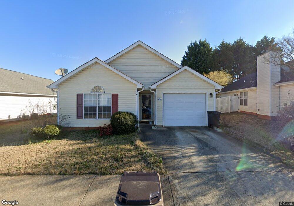
430 Ashton Cir McDonough, GA 30253
Estimated Value: $195,000 - $226,000
2
Beds
2
Baths
1,140
Sq Ft
$185/Sq Ft
Est. Value
About This Home
This home is located at 430 Ashton Cir, McDonough, GA 30253 and is currently estimated at $210,845, approximately $184 per square foot. 430 Ashton Cir is a home located in Henry County with nearby schools including Oakland Elementary School, Eagle's Landing Middle School, and Eagle's Landing High School.
Ownership History
Date
Name
Owned For
Owner Type
Purchase Details
Closed on
Sep 21, 2011
Sold by
Federal Home Loan Mortgage Corporation
Bought by
Watson Anthony Tyronne
Current Estimated Value
Purchase Details
Closed on
Jun 7, 2011
Sold by
Wells Fargo Bk Na
Bought by
Federal Home Loan Mortgage Corporation
Purchase Details
Closed on
Apr 10, 1998
Sold by
Koppar Corp
Bought by
Benefield Margia C and Benefield James W
Home Financials for this Owner
Home Financials are based on the most recent Mortgage that was taken out on this home.
Original Mortgage
$34,350
Interest Rate
7.03%
Mortgage Type
New Conventional
Create a Home Valuation Report for This Property
The Home Valuation Report is an in-depth analysis detailing your home's value as well as a comparison with similar homes in the area
Home Values in the Area
Average Home Value in this Area
Purchase History
| Date | Buyer | Sale Price | Title Company |
|---|---|---|---|
| Watson Anthony Tyronne | $34,900 | -- | |
| Federal Home Loan Mortgage Corporation | -- | -- | |
| Wells Fargo Bk Na | $70,597 | -- | |
| Benefield Margia C | $75,400 | -- |
Source: Public Records
Mortgage History
| Date | Status | Borrower | Loan Amount |
|---|---|---|---|
| Previous Owner | Benefield Margia C | $34,350 |
Source: Public Records
Tax History Compared to Growth
Tax History
| Year | Tax Paid | Tax Assessment Tax Assessment Total Assessment is a certain percentage of the fair market value that is determined by local assessors to be the total taxable value of land and additions on the property. | Land | Improvement |
|---|---|---|---|---|
| 2025 | $3,469 | $86,040 | $12,000 | $74,040 |
| 2024 | $3,469 | $82,320 | $12,000 | $70,320 |
| 2023 | $3,063 | $78,080 | $10,000 | $68,080 |
| 2022 | $2,412 | $61,120 | $10,000 | $51,120 |
| 2021 | $2,001 | $50,400 | $10,000 | $40,400 |
| 2020 | $1,736 | $43,480 | $6,000 | $37,480 |
| 2019 | $1,501 | $37,360 | $6,000 | $31,360 |
| 2018 | $1,278 | $31,560 | $6,000 | $25,560 |
| 2016 | $1,229 | $30,280 | $6,000 | $24,280 |
| 2015 | $1,067 | $25,280 | $6,000 | $19,280 |
| 2014 | $854 | $19,640 | $6,000 | $13,640 |
Source: Public Records
Map
Nearby Homes
- 401 Bainbridge Dr
- 300 Ashton Place
- 41 Birch Ct
- Echo Plan at Kendall Grove - Townhomes
- Aster Plan at Kendall Grove - Single Family Homes
- Spectra Plan at Kendall Grove - Single Family Homes
- Triton Plan at Kendall Grove - Townhomes
- Splendor Plan at Kendall Grove - Single Family Homes
- Beacon Plan at Kendall Grove - Single Family Homes
- Radiance Plan at Kendall Grove - Single Family Homes
- 608 Pelican Place
- 50 Silver Tip Ct
- 1256 Fagiolo St
- 1200 Fagiolo St
- 405 Corricella Ct
- 309 Torcello Blvd
- 1205 Fagiolo St
- 1216 Fagiolo St
- 1204 Fagiolo St
- 317 Torcello Blvd
- 440 Ashton Cir
- 420 Ashton Cir
- 0 Ashton Cir Unit 7014029
- 0 Ashton Cir Unit 7428831
- 0 Ashton Cir Unit 3256315
- 0 Ashton Cir Unit 8255815
- 0 Ashton Cir Unit 7572889
- 0 Ashton Cir Unit 7457517
- 0 Ashton Cir
- 408 Bainbridge Dr
- 426 Bainbridge Dr
- 410 Bainbridge Dr
- 450 Ashton Cir
- 424 Bainbridge Dr
- 410 Ashton Cir
- 412 Bainbridge Dr
- 422 Bainbridge Dr
- 428 Bainbridge Dr
- 428 Bainbridge Dr Unit 1
- 414 Bainbridge Dr