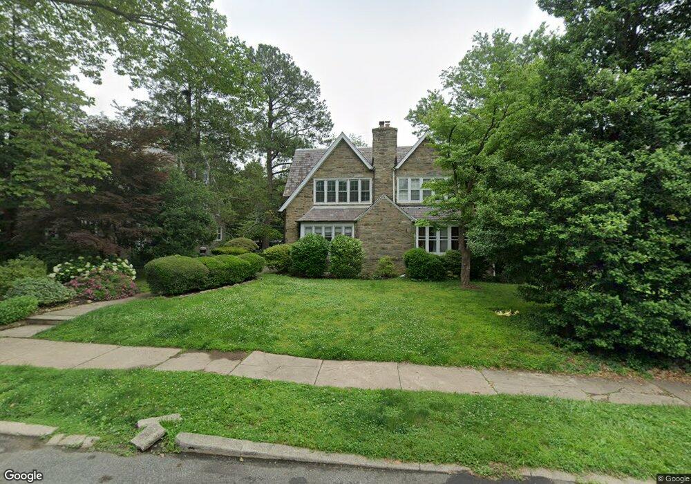
430 E Durham St Philadelphia, PA 19119
East Mount Airy NeighborhoodEstimated Value: $488,000 - $552,000
3
Beds
3
Baths
2,124
Sq Ft
$244/Sq Ft
Est. Value
About This Home
This home is located at 430 E Durham St, Philadelphia, PA 19119 and is currently estimated at $518,776, approximately $244 per square foot. 430 E Durham St is a home located in Philadelphia County with nearby schools including Henry H. Houston School, Roxborough High School, and Renaissance Charter School.
Ownership History
Date
Name
Owned For
Owner Type
Purchase Details
Closed on
Feb 9, 2009
Sold by
Smalls Cassandra and Estate Of Richard T Craig
Bought by
Schueller Danielle
Current Estimated Value
Home Financials for this Owner
Home Financials are based on the most recent Mortgage that was taken out on this home.
Original Mortgage
$270,019
Outstanding Balance
$169,578
Interest Rate
5.06%
Mortgage Type
FHA
Estimated Equity
$349,198
Create a Home Valuation Report for This Property
The Home Valuation Report is an in-depth analysis detailing your home's value as well as a comparison with similar homes in the area
Home Values in the Area
Average Home Value in this Area
Purchase History
| Date | Buyer | Sale Price | Title Company |
|---|---|---|---|
| Schueller Danielle | $275,000 | None Available |
Source: Public Records
Mortgage History
| Date | Status | Borrower | Loan Amount |
|---|---|---|---|
| Open | Schueller Danielle | $270,019 |
Source: Public Records
Tax History Compared to Growth
Tax History
| Year | Tax Paid | Tax Assessment Tax Assessment Total Assessment is a certain percentage of the fair market value that is determined by local assessors to be the total taxable value of land and additions on the property. | Land | Improvement |
|---|---|---|---|---|
| 2026 | $4,906 | $423,300 | $84,660 | $338,640 |
| 2025 | $4,906 | $423,300 | $84,660 | $338,640 |
| 2024 | $4,906 | $423,300 | $84,660 | $338,640 |
| 2023 | $4,906 | $350,500 | $70,100 | $280,400 |
| 2022 | $2,921 | $305,500 | $70,100 | $235,400 |
| 2021 | $3,551 | $0 | $0 | $0 |
| 2020 | $3,551 | $0 | $0 | $0 |
| 2019 | $3,707 | $0 | $0 | $0 |
| 2018 | $3,311 | $0 | $0 | $0 |
| 2017 | $3,730 | $0 | $0 | $0 |
| 2016 | $3,311 | $0 | $0 | $0 |
| 2015 | $3,169 | $0 | $0 | $0 |
| 2014 | -- | $266,500 | $123,937 | $142,563 |
| 2012 | -- | $43,616 | $7,126 | $36,490 |
Source: Public Records
Map
Nearby Homes
- 338 E Mount Airy Ave
- 501 E Sedgwick St
- 407 E Allens Ln
- 523 E Allens Ln
- 6904 Ardleigh St
- 226 E Sedgwick St
- 506 E Gorgas Ln
- 145 E Durham St
- 7410 Crittenden St
- 725 E Vernon Rd
- 932 E Ellet St
- 940 E Allens Ln
- 7415 Sprague St
- 614 E Vernon Rd
- 715 E Dorset St
- 441 E Pleasant St
- 937 E Gorgas Ln
- 1038 E Mount Pleasant Ave
- 505 E Vernon Rd
- 60 E Durham St
- 432 E Durham St
- 428 E Durham St
- 434 E Durham St
- 426 E Durham St
- 424 E Durham St
- 436 E Durham St
- 438 E Durham St
- 422 E Durham St
- 437 E Mount Pleasant Ave
- 420 E Durham St
- 433 E Mount Pleasant Ave
- 418 E Durham St
- 7100 Anderson St
- 429 E Durham St
- 427 E Durham St
- 431 E Durham St
- 500 E Durham St
- 425 E Durham St
- 416 E Durham St
- 433 E Durham St