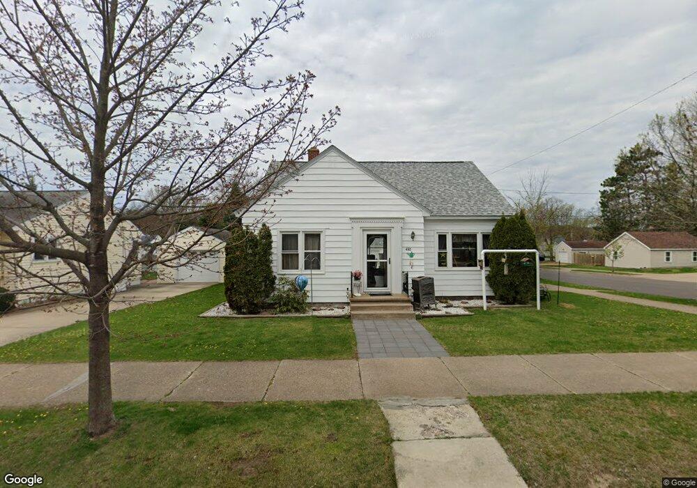
430 N 7th Ave Wausau, WI 54401
Westies NeighborhoodEstimated Value: $179,000 - $210,000
3
Beds
1
Bath
1,250
Sq Ft
$153/Sq Ft
Est. Value
About This Home
This home is located at 430 N 7th Ave, Wausau, WI 54401 and is currently estimated at $190,900, approximately $152 per square foot. 430 N 7th Ave is a home located in Marathon County with nearby schools including Grant Elementary School, John Muir Middle School, and West High School.
Ownership History
Date
Name
Owned For
Owner Type
Purchase Details
Closed on
Jun 26, 2008
Sold by
Otto Jeffrey L
Bought by
Ollhoff Richard J and Hetzel Guyneth L
Current Estimated Value
Home Financials for this Owner
Home Financials are based on the most recent Mortgage that was taken out on this home.
Original Mortgage
$103,574
Outstanding Balance
$66,751
Interest Rate
6.05%
Mortgage Type
Purchase Money Mortgage
Estimated Equity
$124,149
Purchase Details
Closed on
Apr 30, 2007
Sold by
Long Gordon A
Bought by
Otto Jeffrey L
Home Financials for this Owner
Home Financials are based on the most recent Mortgage that was taken out on this home.
Original Mortgage
$60,000
Interest Rate
6.2%
Mortgage Type
Purchase Money Mortgage
Create a Home Valuation Report for This Property
The Home Valuation Report is an in-depth analysis detailing your home's value as well as a comparison with similar homes in the area
Home Values in the Area
Average Home Value in this Area
Purchase History
| Date | Buyer | Sale Price | Title Company |
|---|---|---|---|
| Ollhoff Richard J | $105,200 | None Available | |
| Otto Jeffrey L | $75,000 | None Available |
Source: Public Records
Mortgage History
| Date | Status | Borrower | Loan Amount |
|---|---|---|---|
| Open | Ollhoff Richard J | $103,574 | |
| Previous Owner | Otto Jeffrey L | $60,000 |
Source: Public Records
Tax History Compared to Growth
Tax History
| Year | Tax Paid | Tax Assessment Tax Assessment Total Assessment is a certain percentage of the fair market value that is determined by local assessors to be the total taxable value of land and additions on the property. | Land | Improvement |
|---|---|---|---|---|
| 2024 | $2,825 | $160,400 | $23,100 | $137,300 |
| 2023 | $1,978 | $91,800 | $18,000 | $73,800 |
| 2022 | $2,012 | $91,800 | $18,000 | $73,800 |
| 2021 | $1,927 | $91,800 | $18,000 | $73,800 |
| 2020 | $2,055 | $91,800 | $18,000 | $73,800 |
| 2019 | $2,031 | $86,100 | $13,500 | $72,600 |
| 2018 | $2,211 | $86,100 | $13,500 | $72,600 |
| 2017 | $2,000 | $86,100 | $13,500 | $72,600 |
| 2016 | $1,933 | $86,100 | $13,500 | $72,600 |
| 2015 | $2,127 | $86,100 | $13,500 | $72,600 |
| 2014 | $2,472 | $104,500 | $19,800 | $84,700 |
Source: Public Records
Map
Nearby Homes
- 515 N 8th Ave
- 427 N 6th Ave
- 614 N 10th Ave
- 706 N 9th Ave
- 1104 Holub St
- 314 N 10th Ave
- 802 N 9th Ave
- 1111 Pine St
- 328 N 11th Ave
- 501 N 12th Ave
- 908 N 10th Ave
- 817 N 2nd Ave
- 213 N 17th Ave
- 309 S 5th Ave
- 108 W Strowbridge St
- 102 E Strowbridge St
- 1505 Graham St
- 409 S 12th Ave
- 1311 N 4th Ave
- 101 Short St