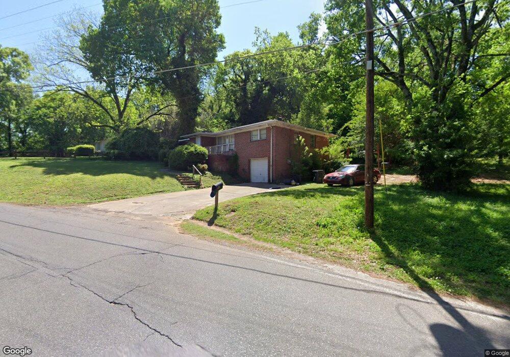
430 Polly Reed Rd Center Point, AL 35215
Estimated Value: $163,000 - $195,000
3
Beds
1
Bath
1,412
Sq Ft
$128/Sq Ft
Est. Value
About This Home
This home is located at 430 Polly Reed Rd, Center Point, AL 35215 and is currently estimated at $180,763, approximately $128 per square foot. 430 Polly Reed Rd is a home located in Jefferson County with nearby schools including Center Point Elementary School, Erwin Elementary School, and Erwin Middle School.
Ownership History
Date
Name
Owned For
Owner Type
Purchase Details
Closed on
Sep 28, 2011
Sold by
The United States Department Of Housing
Bought by
Tobi Properties Llc
Current Estimated Value
Purchase Details
Closed on
Sep 12, 2006
Sold by
Sims Joseph W
Bought by
Moore Adrian L
Home Financials for this Owner
Home Financials are based on the most recent Mortgage that was taken out on this home.
Original Mortgage
$87,900
Interest Rate
6.58%
Mortgage Type
Purchase Money Mortgage
Create a Home Valuation Report for This Property
The Home Valuation Report is an in-depth analysis detailing your home's value as well as a comparison with similar homes in the area
Home Values in the Area
Average Home Value in this Area
Purchase History
| Date | Buyer | Sale Price | Title Company |
|---|---|---|---|
| Tobi Properties Llc | $16,500 | None Available | |
| Moore Adrian L | $87,900 | None Available |
Source: Public Records
Mortgage History
| Date | Status | Borrower | Loan Amount |
|---|---|---|---|
| Previous Owner | Moore Adrian L | $87,900 |
Source: Public Records
Tax History Compared to Growth
Tax History
| Year | Tax Paid | Tax Assessment Tax Assessment Total Assessment is a certain percentage of the fair market value that is determined by local assessors to be the total taxable value of land and additions on the property. | Land | Improvement |
|---|---|---|---|---|
| 2024 | $2,059 | $42,320 | -- | -- |
| 2022 | $1,827 | $33,400 | $4,200 | $29,200 |
| 2021 | $1,655 | $30,040 | $4,200 | $25,840 |
| 2020 | $1,551 | $28,140 | $4,200 | $23,940 |
| 2019 | $1,551 | $28,140 | $0 | $0 |
| 2018 | $1,358 | $24,640 | $0 | $0 |
| 2017 | $1,358 | $24,640 | $0 | $0 |
| 2016 | $1,075 | $21,460 | $0 | $0 |
| 2015 | $1,234 | $24,640 | $0 | $0 |
| 2014 | $1,177 | $23,200 | $0 | $0 |
| 2013 | $1,177 | $23,200 | $0 | $0 |
Source: Public Records
Map
Nearby Homes
- 341 Argonne Dr NE
- 525 Polly Reed Rd
- 1628 Bobolink Ln NE
- 553 Polly Reed Rd
- 1624 Lake Dr NE Unit 1
- 724 Sunny Lane Dr
- 1798 Reed Rd NE
- 133 16th Terrace NE
- 823 Sunny Lane Dr
- 1711 Old Springville Rd
- 904 Kathryne Cir
- 901 Kathryne Cir
- 108 16th Ave NE
- 1804 Stonehenge Dr
- 1617 Old Springville Rd
- 1857 Woodvine Ln
- 1824 Stonehenge Dr
- 1810 Oakleaf Ln
- 1637 1st St NE
- 201 Lake Drive Cir NE
- 438 Polly Reed Rd
- 404 Kim Dr
- 431 Polly Reed Rd
- 435 Polly Reed Rd
- 401 Kim Dr
- 1728 Bobolink Ln NE
- 1700 Barrington Ln NE
- 408 Kim Dr
- 405 Kim Dr
- 1724 Bobolink Ln NE
- 1701 Barrington Ln NE
- 1716 Bobolink Ln NE
- 409 Kim Dr
- 421 Polly Reed Rd
- 1714 Bobolink Ln NE
- 412 Kim Dr
- 1653 Barrington Ln NE
- 1705 Nancy Ln
- 409 Argonne Dr NE
- 1712 Bobolink Ln NE