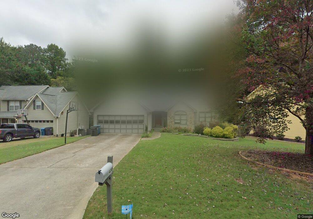
430 Saint Simon's Cove Lawrenceville, GA 30044
Estimated Value: $400,000 - $450,000
3
Beds
2
Baths
2,758
Sq Ft
$151/Sq Ft
Est. Value
About This Home
This home is located at 430 Saint Simon's Cove, Lawrenceville, GA 30044 and is currently estimated at $416,655, approximately $151 per square foot. 430 Saint Simon's Cove is a home located in Gwinnett County with nearby schools including Craig Elementary School, Five Forks Middle School, and Brookwood High School.
Ownership History
Date
Name
Owned For
Owner Type
Purchase Details
Closed on
Jul 12, 2019
Sold by
Bush Brandon L
Bought by
Huey Michael D
Current Estimated Value
Home Financials for this Owner
Home Financials are based on the most recent Mortgage that was taken out on this home.
Original Mortgage
$196,000
Outstanding Balance
$171,713
Interest Rate
3.82%
Mortgage Type
New Conventional
Estimated Equity
$244,942
Create a Home Valuation Report for This Property
The Home Valuation Report is an in-depth analysis detailing your home's value as well as a comparison with similar homes in the area
Home Values in the Area
Average Home Value in this Area
Purchase History
| Date | Buyer | Sale Price | Title Company |
|---|---|---|---|
| Huey Michael D | $245,000 | -- |
Source: Public Records
Mortgage History
| Date | Status | Borrower | Loan Amount |
|---|---|---|---|
| Open | Huey Michael D | $196,000 |
Source: Public Records
Tax History Compared to Growth
Tax History
| Year | Tax Paid | Tax Assessment Tax Assessment Total Assessment is a certain percentage of the fair market value that is determined by local assessors to be the total taxable value of land and additions on the property. | Land | Improvement |
|---|---|---|---|---|
| 2024 | $6,002 | $159,840 | $26,120 | $133,720 |
| 2023 | $6,002 | $162,520 | $31,200 | $131,320 |
| 2022 | $5,123 | $136,080 | $24,800 | $111,280 |
| 2021 | $3,833 | $98,120 | $18,000 | $80,120 |
| 2020 | $3,760 | $95,520 | $18,000 | $77,520 |
| 2019 | $2,636 | $88,640 | $18,000 | $70,640 |
| 2018 | $2,330 | $74,480 | $14,000 | $60,480 |
| 2016 | $2,288 | $71,400 | $12,800 | $58,600 |
| 2015 | $1,954 | $55,240 | $9,200 | $46,040 |
| 2014 | -- | $47,280 | $8,000 | $39,280 |
Source: Public Records
Map
Nearby Homes
- 270 Saint Simons Cove
- 316 Coopers Pond Dr
- 275 Sageglen Rd Unit 2
- 2493 Barndale Dr
- 509 Arnold Rd
- 2518 Candlewood Way
- 305 Melanie Way
- 450 Battersea Dr
- 353 Ansley Brook Dr
- 280 Hayward Ln Unit 1
- 506 Ridgedale Way
- 546 Wagon Wheel Climb Unit 2
- 582 Arnold Rd
- 2575 Kentshire Way
- 2302 Smokehouse Path
- 280 Kentshire Place
- 2532 Gloster Mill Dr SW
- 430 Saint Simons Cove
- 440 Saint Simons Cove
- 420 Saint Simons Cove Unit 3
- 450 Saint Simons Cove Unit 3
- 441 Saint Simons Cove Unit 3
- 410 Saint Simons Cove
- 431 Saint Simons Cove Unit 3
- 421 Saint Simons Cove Unit 3
- 470 Saint Simons Cove Unit 3
- 411 Saint Simons Cove
- 400 Saint Simons Cove
- 395 McKees Rock Ln Unit 2
- 385 McKees Rock Ln
- 451 Saint Simons Cove
- 405 McKees Rock Ln Unit 45
- 405 McKees Rock Ln
- 375 McKees Rock Ln
- 401 Saint Simons Cove
- 461 Saint Simons Cove Unit 3
- 390 Saint Simon's Cove