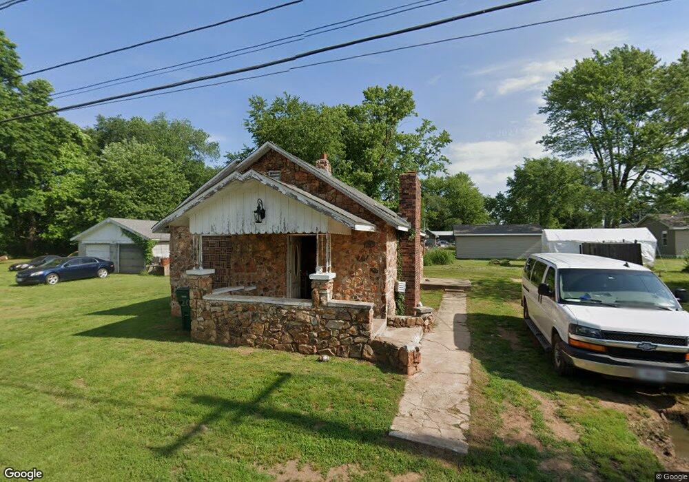
4301 W Helen St Springfield, MO 65802
Estimated Value: $68,090 - $140,000
2
Beds
1
Bath
770
Sq Ft
$147/Sq Ft
Est. Value
About This Home
This home is located at 4301 W Helen St, Springfield, MO 65802 and is currently estimated at $113,273, approximately $147 per square foot. 4301 W Helen St is a home located in Greene County with nearby schools including Willard Intermediate-South and Willard High School.
Ownership History
Date
Name
Owned For
Owner Type
Purchase Details
Closed on
Jul 2, 2008
Sold by
Hsbc Mortgage Services Inc
Bought by
Barrett Fisk Investments Llc
Current Estimated Value
Purchase Details
Closed on
Nov 26, 2007
Sold by
Hansen Peter
Bought by
Hsbc Mortgage Services Inc
Purchase Details
Closed on
Apr 28, 2005
Sold by
Brown Gray L and Brown Cheryl D
Bought by
Hansen Peter
Home Financials for this Owner
Home Financials are based on the most recent Mortgage that was taken out on this home.
Original Mortgage
$50,000
Interest Rate
5.93%
Mortgage Type
New Conventional
Create a Home Valuation Report for This Property
The Home Valuation Report is an in-depth analysis detailing your home's value as well as a comparison with similar homes in the area
Home Values in the Area
Average Home Value in this Area
Purchase History
| Date | Buyer | Sale Price | Title Company |
|---|---|---|---|
| Barrett Fisk Investments Llc | -- | None Available | |
| Hsbc Mortgage Services Inc | $50,773 | Mokan Title Services Inc | |
| Hansen Peter | -- | None Available |
Source: Public Records
Mortgage History
| Date | Status | Borrower | Loan Amount |
|---|---|---|---|
| Previous Owner | Hansen Peter | $50,000 |
Source: Public Records
Tax History Compared to Growth
Tax History
| Year | Tax Paid | Tax Assessment Tax Assessment Total Assessment is a certain percentage of the fair market value that is determined by local assessors to be the total taxable value of land and additions on the property. | Land | Improvement |
|---|---|---|---|---|
| 2025 | $229 | $5,110 | $2,850 | $2,260 |
| 2024 | $229 | $4,160 | $1,900 | $2,260 |
| 2023 | $228 | $4,160 | $1,900 | $2,260 |
| 2022 | $206 | $3,740 | $1,900 | $1,840 |
| 2021 | $206 | $3,740 | $1,900 | $1,840 |
| 2020 | $208 | $3,740 | $1,900 | $1,840 |
| 2019 | $207 | $3,740 | $1,900 | $1,840 |
| 2018 | $265 | $4,750 | $1,900 | $2,850 |
| 2017 | $262 | $4,750 | $1,900 | $2,850 |
| 2016 | $261 | $4,750 | $1,900 | $2,850 |
| 2015 | $259 | $4,750 | $1,900 | $2,850 |
| 2014 | $261 | $4,750 | $1,900 | $2,850 |
Source: Public Records
Map
Nearby Homes
- 4001 W Chestnut Expy
- 4553 W La Siesta St
- 316 S Monterey Ave
- 209 N Miller Ave
- 4211 W Tarkio St
- 4533 W Tarkio St
- 4160 W Tarkio St
- 4037 W Bogard St
- 438 S Lulwood Ave
- 651 S Canton Ave
- 220 N Duke Ave
- 3660 W Dover St
- 518 S Troy Ave
- 4803 W Tilden Ct
- 520 S Troy Ave
- 207 S Dexter Ave
- 452 S Dove Valley Ave
- 4800 W Mount Vernon St
- 4449 W Madison St
- 306 S Dexter Ave
- 601 N Westgate Ave
- 611 N Westgate Ave
- 4308 W Helen St
- 523 N Westgate Ave
- 4312 W Helen St
- 4355 W Helen St
- 515 N Westgate Ave
- 623 N Westgate Ave
- 4324 W Maple St
- 4339 W Helen St
- 4334 W Maple St
- 505 N Westgate Ave
- 4311 W Billings St
- 4322 W Helen St
- 4325 W Billings St
- 633 N Westgate Ave
- 4340 W Maple St
- 501 N Westgate Ave
- 4335 W Billings St
- 4346 W Maple St