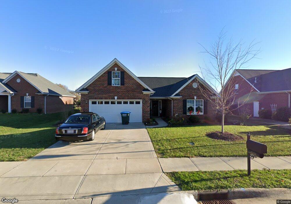
4304 Ethel Sustar Dr Monroe, NC 28110
Estimated Value: $469,534 - $494,000
3
Beds
2
Baths
1,863
Sq Ft
$261/Sq Ft
Est. Value
About This Home
This home is located at 4304 Ethel Sustar Dr, Monroe, NC 28110 and is currently estimated at $486,384, approximately $261 per square foot. 4304 Ethel Sustar Dr is a home located in Union County with nearby schools including Sardis Elementary School, Porter Ridge Middle School, and Porter Ridge High School.
Ownership History
Date
Name
Owned For
Owner Type
Purchase Details
Closed on
Aug 16, 2013
Sold by
Sardis Properties Llc
Bought by
Peacock Miller Joseph Robert and Peacock Miller Deborah
Current Estimated Value
Home Financials for this Owner
Home Financials are based on the most recent Mortgage that was taken out on this home.
Original Mortgage
$140,000
Outstanding Balance
$103,696
Interest Rate
4.29%
Mortgage Type
VA
Estimated Equity
$382,688
Create a Home Valuation Report for This Property
The Home Valuation Report is an in-depth analysis detailing your home's value as well as a comparison with similar homes in the area
Home Values in the Area
Average Home Value in this Area
Purchase History
| Date | Buyer | Sale Price | Title Company |
|---|---|---|---|
| Peacock Miller Joseph Robert | $220,000 | None Available |
Source: Public Records
Mortgage History
| Date | Status | Borrower | Loan Amount |
|---|---|---|---|
| Open | Peacock Miller Joseph Robert | $140,000 |
Source: Public Records
Tax History Compared to Growth
Tax History
| Year | Tax Paid | Tax Assessment Tax Assessment Total Assessment is a certain percentage of the fair market value that is determined by local assessors to be the total taxable value of land and additions on the property. | Land | Improvement |
|---|---|---|---|---|
| 2024 | $2,054 | $321,400 | $62,200 | $259,200 |
| 2023 | $2,032 | $321,400 | $62,200 | $259,200 |
| 2022 | $2,032 | $321,400 | $62,200 | $259,200 |
| 2021 | $2,032 | $321,400 | $62,200 | $259,200 |
| 2020 | $1,733 | $222,300 | $39,000 | $183,300 |
| 2019 | $1,733 | $222,300 | $39,000 | $183,300 |
| 2018 | $0 | $222,300 | $39,000 | $183,300 |
| 2017 | $1,848 | $222,300 | $39,000 | $183,300 |
| 2016 | $1,812 | $222,300 | $39,000 | $183,300 |
| 2015 | $1,840 | $222,300 | $39,000 | $183,300 |
| 2014 | $243 | $241,810 | $34,000 | $207,810 |
Source: Public Records
Map
Nearby Homes
- 5706 Sustar Dr
- 4311 Ethel Sustar Dr
- 5205 Sustar Dr
- 5508 Burning Ridge Dr
- 3900 Crimson Wing Dr
- 3030 Paddington Dr
- 2006 Paddington Dr
- 2026 Union Grove Ln
- 1009 Glen Hollow Dr
- 1010 Glen Hollow Dr
- 0 W Highway 74
- 2842 Gray Fox Rd
- 1009 Kemp Rd
- 1005 Kemp Rd
- 3319 Creek Trail Rd
- 3702 Arthur St
- 3612 Esther St
- 3613 Arthur St
- 3619 Wesley Chapel Stouts Rd
- 2003 Sweet Gum Ct
- 4302 Ethel Sustar Dr
- 4306 Ethel Sustar Dr
- 4310 Ethel Sustar Dr
- 4300 Ethel Sustar Dr
- 4403 Zee Ct
- 4407 Zee Ct
- 4303 Ethel Sustar Dr
- 4312 Ethel Sustar Dr
- 4409 Zee Ct
- 4401 Zee Ct
- 4305 Ethel Sustar Dr
- 4307 Ethel Sustar Dr
- 4301 Ethel Sustar Dr
- 4309 Ethel Sustar Dr
- 4206 Ethel Sustar Dr
- 4314 Ethel Sustar Dr
- 4411 Zee Ct
- 5704 Sustar Dr
- 5200 Sustar Dr
- 4205 Ethel Sustar Dr