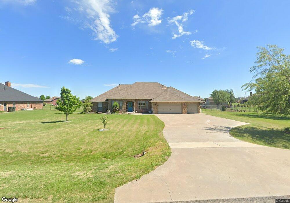
4305 Michael Rd Edmond, OK 73025
Estimated Value: $373,594 - $512,000
4
Beds
3
Baths
2,653
Sq Ft
$164/Sq Ft
Est. Value
About This Home
This home is located at 4305 Michael Rd, Edmond, OK 73025 and is currently estimated at $433,899, approximately $163 per square foot. 4305 Michael Rd is a home located in Logan County with nearby schools including Prairie Vale Elementary School, Deer Creek Middle School, and Deer Creek Intermediate School.
Ownership History
Date
Name
Owned For
Owner Type
Purchase Details
Closed on
Dec 5, 2024
Sold by
Firth Charmaine M and Firth Dayne R
Bought by
Firth Revocable Trust and Firth
Current Estimated Value
Purchase Details
Closed on
Aug 7, 2006
Sold by
Dean Macrory Homes Inc
Bought by
Firth Charmaine M and Firth Dayne R
Home Financials for this Owner
Home Financials are based on the most recent Mortgage that was taken out on this home.
Original Mortgage
$188,720
Interest Rate
6.77%
Mortgage Type
New Conventional
Create a Home Valuation Report for This Property
The Home Valuation Report is an in-depth analysis detailing your home's value as well as a comparison with similar homes in the area
Purchase History
We collect this data history from publicly available records. To have your information removed, we recommend requesting removal directly through your county’s website.
| Date | Buyer | Sale Price | Title Company |
|---|---|---|---|
| Firth Revocable Trust | -- | None Listed On Document | |
| Firth Revocable Trust | -- | None Listed On Document | |
| Firth Charmaine M | $236,000 | None Available |
Source: Public Records
Mortgage History
We collect this data history from publicly available records. To have your information removed, we recommend requesting removal directly through your county’s website.
| Date | Status | Borrower | Loan Amount |
|---|---|---|---|
| Previous Owner | Firth Charmaine M | $188,720 |
Source: Public Records
Tax History
| Year | Tax Paid | Tax Assessment Tax Assessment Total Assessment is a certain percentage of the fair market value that is determined by local assessors to be the total taxable value of land and additions on the property. | Land | Improvement |
|---|---|---|---|---|
| 2025 | $3,501 | $31,084 | $4,015 | $27,069 |
| 2024 | $3,461 | $30,178 | $4,015 | $26,163 |
| 2023 | $3,461 | $29,299 | $4,015 | $25,284 |
| 2022 | $3,140 | $28,446 | $4,015 | $24,431 |
| 2021 | $3,086 | $28,400 | $4,015 | $24,385 |
| 2020 | $3,097 | $27,573 | $4,015 | $23,558 |
| 2019 | $3,135 | $27,573 | $4,015 | $23,558 |
| 2018 | $3,091 | $27,405 | $3,575 | $23,830 |
| 2017 | $3,078 | $27,113 | $3,236 | $23,877 |
| 2016 | $2,966 | $26,323 | $2,761 | $23,562 |
| 2014 | $2,846 | $25,979 | $2,200 | $23,779 |
| 2013 | $3,164 | $28,341 | $2,400 | $25,941 |
Source: Public Records
Map
Nearby Homes
- 4174 Michael Rd
- 4221 Darril Rd
- 4080 Darril Rd
- 13075 Mannington Rd
- 12974 Mannington Rd
- 7025 Orchard View
- 9070 Oak Tree Cir
- 9010 Oak Tree Cir
- 8920 Oak Tree Cir
- 8890 Oak Tree Cir
- 8681 Oak Tree Cir
- 8740 Oak Tree Cir
- 13460 Blue Star St
- 8591 Oak Tree Cir
- 8650 Oak Tree Cir
- 8561 Oak Tree Cir
- 4745 Ranchero Dr
- 4640 Ranchero Dr
- 9881 Livingston Rd
- 13420 Saltgrass Dr
- 4315 Michael Rd
- 4255 Michael Rd
- 4195 Michael Rd
- 4335 Michael Rd
- 4304 Michael Rd
- 4252 Darril Rd
- 4324 Michael Rd
- 4274 Michael Rd
- 4282 Darril Rd
- 4222 Darril Rd
- 4175 Michael Rd
- 4355 Michael Rd
- 4234 Michael Rd
- 4354 Michael Rd
- 4312 Darril Rd
- 4192 Darril Rd
- 4145 Michael Rd
- 4204 Michael Rd
- 4162 Darril Rd
- 4342 Darril Rd
Your Personal Tour Guide
Ask me questions while you tour the home.