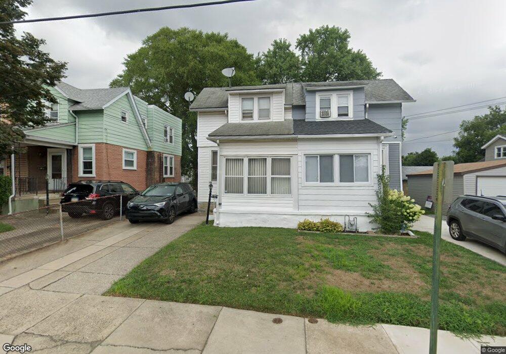
431 Arbor Rd Lansdowne, PA 19050
Estimated Value: $193,000 - $211,000
2
Beds
1
Bath
1,134
Sq Ft
$179/Sq Ft
Est. Value
About This Home
This home is located at 431 Arbor Rd, Lansdowne, PA 19050 and is currently estimated at $202,663, approximately $178 per square foot. 431 Arbor Rd is a home located in Delaware County with nearby schools including Evans Elementary School, Penn Wood Middle School, and Penn Wood High School - Cypress Street Campus.
Ownership History
Date
Name
Owned For
Owner Type
Purchase Details
Closed on
Jan 16, 2025
Sold by
Guy Leroy
Bought by
Guardian/Jmg Tax Llc
Current Estimated Value
Purchase Details
Closed on
Mar 20, 2024
Sold by
County Of Delaware
Bought by
Guy Leroy
Purchase Details
Closed on
Jul 18, 2001
Sold by
Kemp Eric and Estate Of Patricia Marie There
Bought by
Henry Wendy A
Home Financials for this Owner
Home Financials are based on the most recent Mortgage that was taken out on this home.
Original Mortgage
$43,920
Interest Rate
10.14%
Purchase Details
Closed on
Mar 25, 1999
Sold by
Johnson Agnes T
Bought by
Kemp Patricia Marie Theresa Johnson
Create a Home Valuation Report for This Property
The Home Valuation Report is an in-depth analysis detailing your home's value as well as a comparison with similar homes in the area
Home Values in the Area
Average Home Value in this Area
Purchase History
| Date | Buyer | Sale Price | Title Company |
|---|---|---|---|
| Guardian/Jmg Tax Llc | -- | None Listed On Document | |
| Guy Leroy | $63,000 | None Listed On Document | |
| Henry Wendy A | $54,900 | -- | |
| Kemp Patricia Marie Theresa Johnson | -- | -- |
Source: Public Records
Mortgage History
| Date | Status | Borrower | Loan Amount |
|---|---|---|---|
| Previous Owner | Henry Wendy A | $43,920 | |
| Closed | Henry Wendy A | $8,000 |
Source: Public Records
Tax History
| Year | Tax Paid | Tax Assessment Tax Assessment Total Assessment is a certain percentage of the fair market value that is determined by local assessors to be the total taxable value of land and additions on the property. | Land | Improvement |
|---|---|---|---|---|
| 2025 | $4,420 | $103,520 | $33,410 | $70,110 |
| 2024 | $4,420 | $103,520 | $33,410 | $70,110 |
| 2023 | $4,015 | $103,520 | $33,410 | $70,110 |
| 2022 | $3,828 | $103,520 | $33,410 | $70,110 |
| 2021 | $5,789 | $103,520 | $33,410 | $70,110 |
| 2020 | $3,776 | $60,470 | $19,280 | $41,190 |
| 2019 | $3,710 | $60,470 | $19,280 | $41,190 |
| 2018 | $3,658 | $60,470 | $0 | $0 |
| 2017 | $3,582 | $60,470 | $0 | $0 |
| 2016 | $339 | $60,470 | $0 | $0 |
| 2015 | $332 | $60,470 | $0 | $0 |
| 2014 | $332 | $60,470 | $0 | $0 |
Source: Public Records
Map
Nearby Homes
- 417 Laurel Rd
- 401 Holly Rd
- 442 Church Ln
- 438 Church Ln
- 436 Church Ln
- 530 Orchard Ave
- 622 Yeadon Ave
- 104 Oak Ave
- 702 Cedar Ave
- 912 Whitby Ave
- 1016 Whitby Ave
- 7010 Atlantic Ave
- 22 Lexington Ave
- 7117 Atlantic Ave
- 57 Lexington Ave
- 1200 Angora Dr
- 734 Bullock Ave
- 1208 S Millick St
- 1201 S Millick St
- 1303 Manor Rd
Your Personal Tour Guide
Ask me questions while you tour the home.