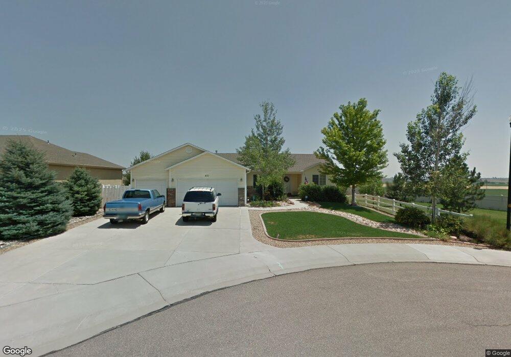
431 Hawthorne Ave Johnstown, CO 80534
Estimated Value: $515,000 - $578,000
3
Beds
3
Baths
1,646
Sq Ft
$334/Sq Ft
Est. Value
About This Home
This home is located at 431 Hawthorne Ave, Johnstown, CO 80534 and is currently estimated at $550,047, approximately $334 per square foot. 431 Hawthorne Ave is a home located in Weld County with nearby schools including Pioneer Ridge Elementary School, Milliken Middle School, and Roosevelt High School.
Ownership History
Date
Name
Owned For
Owner Type
Purchase Details
Closed on
Sep 26, 2002
Sold by
Executive Homes Inc
Bought by
Derock Leo M and Derock Patricia A
Current Estimated Value
Home Financials for this Owner
Home Financials are based on the most recent Mortgage that was taken out on this home.
Original Mortgage
$134,100
Outstanding Balance
$56,426
Interest Rate
6.21%
Estimated Equity
$493,621
Create a Home Valuation Report for This Property
The Home Valuation Report is an in-depth analysis detailing your home's value as well as a comparison with similar homes in the area
Home Values in the Area
Average Home Value in this Area
Purchase History
| Date | Buyer | Sale Price | Title Company |
|---|---|---|---|
| Derock Leo M | $234,100 | -- |
Source: Public Records
Mortgage History
| Date | Status | Borrower | Loan Amount |
|---|---|---|---|
| Open | Derock Leo M | $134,100 |
Source: Public Records
Tax History Compared to Growth
Tax History
| Year | Tax Paid | Tax Assessment Tax Assessment Total Assessment is a certain percentage of the fair market value that is determined by local assessors to be the total taxable value of land and additions on the property. | Land | Improvement |
|---|---|---|---|---|
| 2025 | $2,735 | $35,200 | $7,060 | $28,140 |
| 2024 | $2,735 | $35,200 | $7,060 | $28,140 |
| 2023 | $2,568 | $38,510 | $5,750 | $32,760 |
| 2022 | $2,430 | $29,610 | $4,870 | $24,740 |
| 2021 | $2,619 | $30,460 | $5,010 | $25,450 |
| 2020 | $2,206 | $27,350 | $4,650 | $22,700 |
| 2019 | $1,726 | $27,350 | $4,650 | $22,700 |
| 2018 | $1,397 | $23,540 | $3,740 | $19,800 |
| 2017 | $2,046 | $23,540 | $3,740 | $19,800 |
| 2016 | $1,770 | $20,360 | $3,180 | $17,180 |
| 2015 | $1,794 | $20,360 | $3,180 | $17,180 |
| 2014 | $1,684 | $19,720 | $1,590 | $18,130 |
Source: Public Records
Map
Nearby Homes
- 264 Alder Ave
- 312 Hummingbird Ln
- 309 Scaup Ln
- 310 Shoveler Way
- 242 Scaup Ln
- 311 Shoveler Way
- 299 Shoveler Way
- 287 Shoveler Way
- 275 Shoveler Way
- 2730 Wren Dr
- Biscayne Plan at Johnstown Village - Pintail Commons
- Denali Plan at Johnstown Village - Pintail Commons
- Acadia Plan at Johnstown Village - Pintail Commons
- Congaree Plan at Johnstown Village - Pintail Commons
- 286 Shoveler Way
- 217 Sparrow Dr
- 203 Sparrow Dr
- GABLE Plan at Mallard Ridge
- NEWCASTLE Plan at Mallard Ridge
- BRIDGEPORT Plan at Mallard Ridge
- 425 Hawthorne Ave
- 419 Hawthorne Ave
- 420 Hawthorne Ave
- 426 Hawthorne Ave
- 413 Hawthorne Ave
- 414 Hawthorne Ave
- 3138 Woodbine Ln
- 407 Hawthorne Ave
- 3132 Woodbine Ln
- 408 Hawthorne Ave
- 419 Hickory Ln
- 425 Hickory Ln
- 413 Hickory Ln
- 3120 Woodbine Ln
- 3120 Woodbine Ln Unit 1
- 402 Hawthorne Ave
- 407 Hickory Ln
- 349 Hawthorne Ave
- 3114 Woodbine Ln
- 348 Buckeye Ave