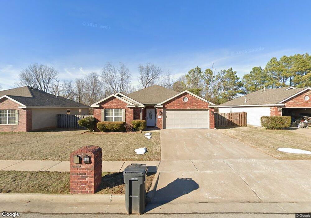
431 Mccann Rd Rogers, AR 72758
Estimated Value: $265,000 - $299,000
Studio
2
Baths
1,334
Sq Ft
$214/Sq Ft
Est. Value
About This Home
This home is located at 431 Mccann Rd, Rogers, AR 72758 and is currently estimated at $285,500, approximately $214 per square foot. 431 Mccann Rd is a home located in Benton County with nearby schools including Jones Elementary School, Kirksey Middle School, and Rogers High School.
Ownership History
Date
Name
Owned For
Owner Type
Purchase Details
Closed on
May 21, 2021
Sold by
Ambriz Marco A
Bought by
Ambriz Marco A and Reyes Cindy M
Current Estimated Value
Home Financials for this Owner
Home Financials are based on the most recent Mortgage that was taken out on this home.
Original Mortgage
$146,825
Outstanding Balance
$132,565
Interest Rate
3%
Mortgage Type
New Conventional
Estimated Equity
$152,935
Purchase Details
Closed on
May 21, 2019
Sold by
Betty Caroll Quimby Special Needs Trust
Bought by
Ambriz Marco A
Home Financials for this Owner
Home Financials are based on the most recent Mortgage that was taken out on this home.
Original Mortgage
$146,300
Interest Rate
4.1%
Mortgage Type
New Conventional
Purchase Details
Closed on
Apr 4, 2008
Sold by
Paul Pinkley Construction Inc
Bought by
Peatross Scott and Betty Quimby Special Needs Trust
Create a Home Valuation Report for This Property
The Home Valuation Report is an in-depth analysis detailing your home's value as well as a comparison with similar homes in the area
Home Values in the Area
Average Home Value in this Area
Purchase History
| Date | Buyer | Sale Price | Title Company |
|---|---|---|---|
| Ambriz Marco A | -- | City Title & Closing | |
| Ambriz Marco A | $154,000 | Pci Advance Title | |
| Peatross Scott | $115,000 | Lenders Title Company |
Source: Public Records
Mortgage History
| Date | Status | Borrower | Loan Amount |
|---|---|---|---|
| Open | Ambriz Marco A | $146,825 | |
| Previous Owner | Ambriz Marco A | $146,300 |
Source: Public Records
Tax History
| Year | Tax Paid | Tax Assessment Tax Assessment Total Assessment is a certain percentage of the fair market value that is determined by local assessors to be the total taxable value of land and additions on the property. | Land | Improvement |
|---|---|---|---|---|
| 2025 | $1,809 | $49,142 | $8,000 | $41,142 |
| 2024 | $1,685 | $49,142 | $8,000 | $41,142 |
| 2023 | $1,604 | $34,600 | $6,000 | $28,600 |
| 2022 | $1,221 | $34,600 | $6,000 | $28,600 |
| 2021 | $1,144 | $34,600 | $6,000 | $28,600 |
| 2020 | $1,073 | $26,370 | $4,600 | $21,770 |
| 2019 | $888 | $26,370 | $4,600 | $21,770 |
| 2018 | $913 | $26,370 | $4,600 | $21,770 |
| 2017 | $844 | $26,370 | $4,600 | $21,770 |
| 2016 | $844 | $26,370 | $4,600 | $21,770 |
| 2015 | $1,217 | $23,130 | $5,000 | $18,130 |
| 2014 | $867 | $23,130 | $5,000 | $18,130 |
Source: Public Records
Map
Nearby Homes
- 3.48AC Mccann Rd
- 2402 S D St
- 603 E Sandalwood St
- 3111 S G St
- 811 E Southern Trace Dr
- 2021 S B Place
- 2011 & 2013 S G St
- 302 E Southpointe Ave
- 1909 & 1911 S F St
- Tract 3 Pinewoods Dr
- 304 E Laurel Ave
- 9.02 Acres W Dyke Rd
- 12782 Stoney Point Rd
- 1818 S H St
- 1813 S J St
- 1809 S G St
- 1306 E Kara Ln
- 818 E Kiwi St
- 1824 S G St
- 2211 S 9th St
Your Personal Tour Guide
Ask me questions while you tour the home.