Estimated Value: $142,143 - $196,000
4
Beds
2
Baths
1,872
Sq Ft
$89/Sq Ft
Est. Value
About This Home
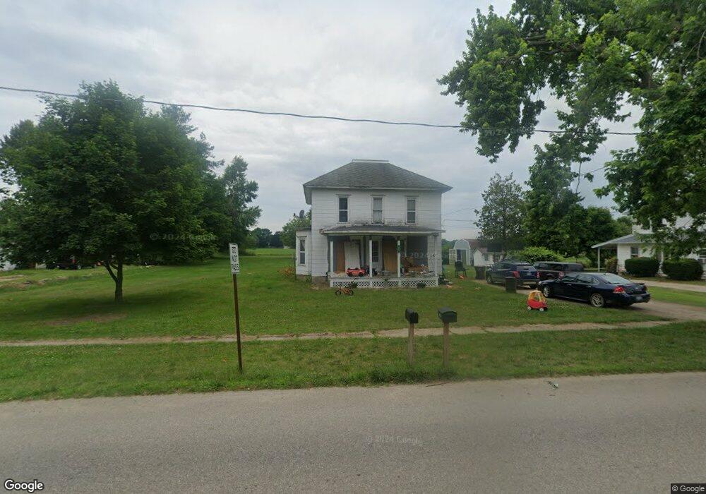
This home is located at 431 N Ovid St, Elsie, MI 48831 and is currently estimated at $165,786, approximately $88 per square foot. 431 N Ovid St is a home located in Clinton County with nearby schools including E.E. Knight Elementary School, Leonard Elementary School, and Ovid-Elsie Middle School.
Ownership History
Date
Name
Owned For
Owner Type
Purchase Details
Closed on
Oct 5, 2024
Sold by
Confer Emily Ruth
Bought by
Confer Nicholas Wayne
Current Estimated Value
Purchase Details
Closed on
Aug 22, 2020
Sold by
Washburn Kam J and Washbum Kathleen D
Bought by
Confer Nicholas and Confer Emily
Purchase Details
Closed on
Jan 10, 2004
Sold by
Washburn Kam J and Washburn Kathleen D
Bought by
Mowl Darell J
Home Financials for this Owner
Home Financials are based on the most recent Mortgage that was taken out on this home.
Original Mortgage
$50,000
Interest Rate
7%
Mortgage Type
Seller Take Back
Create a Home Valuation Report for This Property
The Home Valuation Report is an in-depth analysis detailing your home's value as well as a comparison with similar homes in the area
Home Values in the Area
Average Home Value in this Area
Purchase History
| Date | Buyer | Sale Price | Title Company |
|---|---|---|---|
| Confer Nicholas Wayne | -- | None Listed On Document | |
| Confer Nicholas | -- | None Available | |
| Mowl Darell J | $50,000 | -- |
Source: Public Records
Mortgage History
| Date | Status | Borrower | Loan Amount |
|---|---|---|---|
| Previous Owner | Mowl Darell J | $50,000 |
Source: Public Records
Tax History Compared to Growth
Tax History
| Year | Tax Paid | Tax Assessment Tax Assessment Total Assessment is a certain percentage of the fair market value that is determined by local assessors to be the total taxable value of land and additions on the property. | Land | Improvement |
|---|---|---|---|---|
| 2025 | $343 | $32,300 | $6,600 | $25,700 |
| 2024 | $130 | $31,200 | $6,600 | $24,600 |
| 2023 | $123 | $26,700 | $0 | $0 |
| 2022 | $305 | $24,300 | $6,600 | $17,700 |
| 2021 | $317 | $22,900 | $5,900 | $17,000 |
| 2020 | $423 | $21,600 | $6,300 | $15,300 |
| 2019 | $264 | $9,300 | $6,300 | $3,000 |
| 2018 | $264 | $9,300 | $6,300 | $3,000 |
| 2017 | -- | $10,000 | $7,100 | $2,900 |
| 2016 | -- | $10,000 | $7,100 | $2,900 |
| 2015 | -- | $9,700 | $0 | $0 |
| 2011 | -- | $11,800 | $0 | $0 |
Source: Public Records
Map
Nearby Homes
- 204 W Pine St
- 228 E Pine St
- 229 W Maple St
- 323 E Main St
- 7060 E Maple Rapids Rd
- 4321 N Upton Rd
- 000 W Huff Rd
- 5752 E Colony Rd
- 0 E Colony Rd Unit 286182
- 11550 S Wisner Rd
- 10230 E Cleveland Rd
- 1 Peet Rd
- 218 W High St
- 228 W Pearl St
- 306 N Main St
- 222 N Main St
- 210 W Front St
- 217 W Clinton St
- 8311 N Friegel Rd
- 7902 N Welling Rd