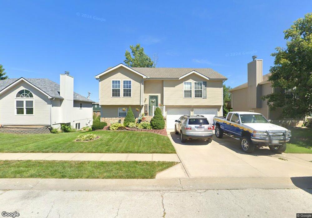
431 N Queen Ridge Ave Independence, MO 64056
Randall NeighborhoodEstimated Value: $237,762 - $250,000
3
Beds
2
Baths
1,128
Sq Ft
$215/Sq Ft
Est. Value
About This Home
This home is located at 431 N Queen Ridge Ave, Independence, MO 64056 and is currently estimated at $242,441, approximately $214 per square foot. 431 N Queen Ridge Ave is a home located in Jackson County with nearby schools including Randall Elementary School, Bridger Middle School, and Bingham Middle School.
Ownership History
Date
Name
Owned For
Owner Type
Purchase Details
Closed on
Aug 13, 2010
Sold by
Deere Sara
Bought by
Alivares Bobadilla Salvador Acosta and Alivares Ramirez Aidee
Current Estimated Value
Home Financials for this Owner
Home Financials are based on the most recent Mortgage that was taken out on this home.
Original Mortgage
$93,600
Outstanding Balance
$61,879
Interest Rate
4.54%
Mortgage Type
New Conventional
Estimated Equity
$180,562
Purchase Details
Closed on
Oct 22, 2004
Sold by
G Barnhart Construction Co Inc
Bought by
Deere Sara
Home Financials for this Owner
Home Financials are based on the most recent Mortgage that was taken out on this home.
Original Mortgage
$101,144
Interest Rate
6.39%
Mortgage Type
Purchase Money Mortgage
Create a Home Valuation Report for This Property
The Home Valuation Report is an in-depth analysis detailing your home's value as well as a comparison with similar homes in the area
Home Values in the Area
Average Home Value in this Area
Purchase History
| Date | Buyer | Sale Price | Title Company |
|---|---|---|---|
| Alivares Bobadilla Salvador Acosta | -- | Chicago | |
| Deere Sara | -- | Stewart Title |
Source: Public Records
Mortgage History
| Date | Status | Borrower | Loan Amount |
|---|---|---|---|
| Open | Alivares Bobadilla Salvador Acosta | $93,600 | |
| Previous Owner | Deere Sara | $101,144 | |
| Closed | Deere Sara | $25,286 |
Source: Public Records
Tax History Compared to Growth
Tax History
| Year | Tax Paid | Tax Assessment Tax Assessment Total Assessment is a certain percentage of the fair market value that is determined by local assessors to be the total taxable value of land and additions on the property. | Land | Improvement |
|---|---|---|---|---|
| 2025 | $2,579 | $40,455 | $5,157 | $35,298 |
| 2024 | $2,520 | $37,225 | $3,779 | $33,446 |
| 2023 | $2,520 | $37,225 | $3,927 | $33,298 |
| 2022 | $2,260 | $30,590 | $3,868 | $26,722 |
| 2021 | $2,259 | $30,590 | $3,868 | $26,722 |
| 2020 | $2,074 | $27,296 | $3,868 | $23,428 |
| 2019 | $2,041 | $27,296 | $3,868 | $23,428 |
| 2018 | $1,861 | $23,756 | $3,366 | $20,390 |
| 2017 | $1,861 | $23,756 | $3,366 | $20,390 |
| 2016 | $1,775 | $22,443 | $4,110 | $18,333 |
| 2014 | $1,686 | $21,789 | $3,990 | $17,799 |
Source: Public Records
Map
Nearby Homes
- 16104 E Cogan Ln
- 320 N M 291 Hwy
- 101 S Lacy Rd
- 17315 E 6th Terrace Ct N
- 17501 E Cheyenne Dr
- 17008 E 2nd St S
- 17008 E Salisbury Rd
- 813 N Pawnee Ave
- 16916 E 3rd St S
- 0 Bundschu Rd Unit HMS2577360
- 17611 E Susquehanna Dr
- 1609 N Howard Dr
- 805 N Allen Rd
- 1875 E Mechanic Ave
- 802 N Ute St
- 18000 E Dakota Dr
- 607 S Lacy Rd
- 704 S Lacy Rd
- 1201 N Indian Ln
- 0 N Allen Rd
- 435 N Queen Ridge Ave
- 427 N Queen Ridge Ave
- 439 N Queen Ridge Ave
- 423 N Queen Ridge Ave
- 428 N Queen Ridge Ave
- 424 N Queen Ridge Ave
- 436 N Queen Ridge Ave
- 419 N Queen Ridge Ave
- 443 N Queen Ridge Ave
- 440 N Queen Ridge Ave
- 420 N Queen Ridge Ave
- 415 N Queen Ridge Ave
- 444 N Queen Ridge Ave
- 416 N Queen Ridge Ave
- 411 N Queen Ridge Ave
- 412 N Queen Ridge Ave
- 407 N Queen Ridge Ave
- 408 N Queen Ridge Ave
- 16418 E 4th Street Ct N
- 16422 E 4th Street Ct N