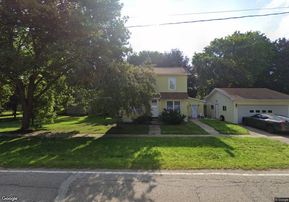
431 S Maple Ave Maple Rapids, MI 48853
Estimated Value: $151,000 - $169,000
3
Beds
1
Bath
1,232
Sq Ft
$129/Sq Ft
Est. Value
About This Home
This home is located at 431 S Maple Ave, Maple Rapids, MI 48853 and is currently estimated at $158,917, approximately $128 per square foot. 431 S Maple Ave is a home with nearby schools including Fulton Elementary School, Fulton Middle School, and Fulton High School.
Ownership History
Date
Name
Owned For
Owner Type
Purchase Details
Closed on
Mar 25, 2025
Sold by
Powers Ronnie L
Bought by
Powers Ronnie L and Ronnie L Powers Living Trust
Current Estimated Value
Purchase Details
Closed on
Apr 29, 2020
Sold by
Brock Kirk D and Norman J Brock Living Trust
Bought by
Powers Ronnie L
Purchase Details
Closed on
Nov 28, 2011
Sold by
Brock Norma J and Brock Donald C
Bought by
Brock Norma J and Brock Living Trust
Create a Home Valuation Report for This Property
The Home Valuation Report is an in-depth analysis detailing your home's value as well as a comparison with similar homes in the area
Purchase History
| Date | Buyer | Sale Price | Title Company |
|---|---|---|---|
| Powers Ronnie L | -- | None Listed On Document | |
| Powers Ronnie L | $72,500 | Ata National Title Group Llc | |
| Brock Norma J | -- | None Available |
Source: Public Records
Tax History
| Year | Tax Paid | Tax Assessment Tax Assessment Total Assessment is a certain percentage of the fair market value that is determined by local assessors to be the total taxable value of land and additions on the property. | Land | Improvement |
|---|---|---|---|---|
| 2025 | $1,192 | $61,100 | $7,800 | $53,300 |
| 2024 | $6 | $54,800 | $7,100 | $47,700 |
| 2023 | $534 | $51,500 | $0 | $0 |
| 2022 | $1,108 | $46,800 | $6,400 | $40,400 |
| 2021 | $1,079 | $41,600 | $6,200 | $35,400 |
| 2020 | $721 | $39,300 | $6,000 | $33,300 |
| 2019 | $678 | $34,500 | $6,000 | $28,500 |
| 2018 | $0 | $33,600 | $6,000 | $27,600 |
| 2017 | -- | $35,700 | $6,000 | $29,700 |
| 2016 | $643 | $34,100 | $6,000 | $28,100 |
| 2015 | -- | $32,400 | $0 | $0 |
| 2011 | -- | $32,900 | $0 | $0 |
Source: Public Records
Map
Nearby Homes
- 132 E Washington St
- 129 E Main St
- 220 N Maple Ave
- TBD E Main St
- 7240 Empire Rd
- 8150 Idared Rd
- 8095 Mcintosh Rd
- 9515 W Moss Rd
- 00 S Skyline
- 7150 W Mead Rd
- 4941 Skyline Dr
- 005 Skyline Dr
- 159 Hardwood Trail
- TBD Hardwood Trail
- TBD Oakridge Trail
- Lot 355 Oakridge Trail
- 04 Lakeview Ct
- 05 Lakeview Ct
- 00 W Ranger Rd
- 0 Lakeside Dr Unit LOT 1 3520630
Your Personal Tour Guide
Ask me questions while you tour the home.