Estimated Value: $312,501 - $385,000
4
Beds
3
Baths
1,872
Sq Ft
$182/Sq Ft
Est. Value
About This Home
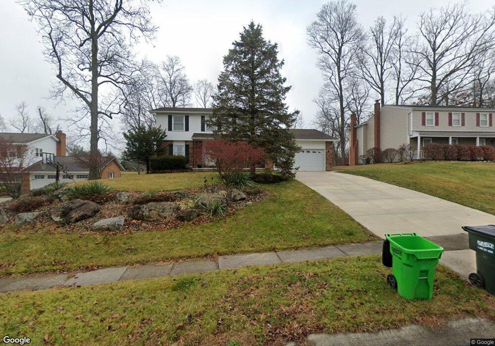
This home is located at 431 Treeside Dr, Stow, OH 44224 and is currently estimated at $340,875, approximately $182 per square foot. 431 Treeside Dr is a home located in Summit County with nearby schools including Stow-Munroe Falls High School, Immaculate Heart Of Mary School, and Summit Christian School.
Ownership History
Date
Name
Owned For
Owner Type
Purchase Details
Closed on
Jul 12, 2006
Sold by
Evans Robert E and Evans Nancy A
Bought by
Evans Steven E and Evans Laura K
Current Estimated Value
Home Financials for this Owner
Home Financials are based on the most recent Mortgage that was taken out on this home.
Original Mortgage
$123,600
Interest Rate
6.72%
Mortgage Type
Purchase Money Mortgage
Create a Home Valuation Report for This Property
The Home Valuation Report is an in-depth analysis detailing your home's value as well as a comparison with similar homes in the area
Home Values in the Area
Average Home Value in this Area
Purchase History
| Date | Buyer | Sale Price | Title Company |
|---|---|---|---|
| Evans Steven E | $155,000 | Chicago Title Insurance Co |
Source: Public Records
Mortgage History
| Date | Status | Borrower | Loan Amount |
|---|---|---|---|
| Closed | Evans Steven E | $123,600 |
Source: Public Records
Tax History Compared to Growth
Tax History
| Year | Tax Paid | Tax Assessment Tax Assessment Total Assessment is a certain percentage of the fair market value that is determined by local assessors to be the total taxable value of land and additions on the property. | Land | Improvement |
|---|---|---|---|---|
| 2024 | $4,175 | $73,805 | $12,054 | $61,751 |
| 2023 | $4,175 | $73,805 | $12,054 | $61,751 |
| 2022 | $4,537 | $70,966 | $11,592 | $59,374 |
| 2021 | $4,063 | $70,966 | $11,592 | $59,374 |
| 2020 | $3,993 | $70,960 | $11,590 | $59,370 |
| 2019 | $3,477 | $57,640 | $11,590 | $46,050 |
| 2018 | $3,421 | $57,640 | $11,590 | $46,050 |
| 2017 | $3,216 | $57,640 | $11,590 | $46,050 |
| 2016 | $3,305 | $52,620 | $11,590 | $41,030 |
| 2015 | $3,216 | $52,620 | $11,590 | $41,030 |
| 2014 | $3,219 | $52,620 | $11,590 | $41,030 |
| 2013 | $3,135 | $51,550 | $11,590 | $39,960 |
Source: Public Records
Map
Nearby Homes
- V/L Diplomat Dr
- 4844 State Rd
- PARKETTE Plan at Reserve at Boulder Estates
- BUCHANAN Plan at Reserve at Boulder Estates
- BEACHWOOD Plan at Reserve at Boulder Estates
- VANDERBURGH Plan at Reserve at Boulder Estates
- BELLEVILLE Plan at Reserve at Boulder Estates
- ALDEN Plan at Reserve at Boulder Estates
- HOLLISTER Plan at Reserve at Boulder Estates
- 4850 State Rd
- 52 Boulder Blvd
- 4615 Lakeside Oval
- 220 Salt Creek Run
- 5005 Little Brook Dr
- 5469 Sullivan Rd
- V/L Housley Rd
- 3751 Wyoga Lake Rd
- 4017 Bellaire Ln
- 1203 Meadowbrook Blvd
- 5112 Commanche Trail
- 439 Treeside Dr
- 421 Treeside Dr
- 447 Treeside Dr
- 413 Treeside Dr
- 438 Treeside Dr
- 420 Treeside Dr
- 403 Treeside Dr
- 457 Treeside Dr
- 450 Treeside Dr
- 4477 Deauville Ave
- 4476 Deauville Ave
- 465 Treeside Dr
- 458 Treeside Dr
- 396 Treeside Dr
- 4466 Deauville Ave
- 466 Treeside Dr
- 4469 Deauville Ave
- 473 Treeside Dr
- 393 Treeside Dr
- 386 Treeside Dr