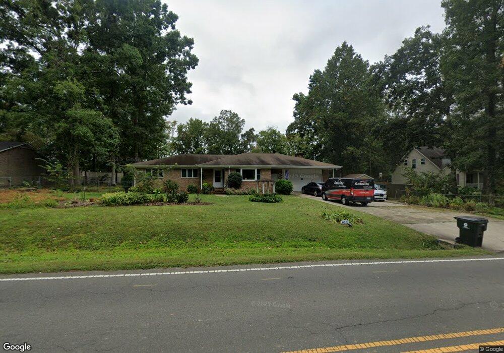
4310 Holder Rd Durham, NC 27703
Eastern Durham NeighborhoodEstimated Value: $379,882 - $415,000
3
Beds
2
Baths
2,036
Sq Ft
$196/Sq Ft
Est. Value
About This Home
This home is located at 4310 Holder Rd, Durham, NC 27703 and is currently estimated at $398,721, approximately $195 per square foot. 4310 Holder Rd is a home located in Durham County with nearby schools including Spring Valley Elementary School, John W Neal Middle School, and Southern School of Energy & Sustainability.
Ownership History
Date
Name
Owned For
Owner Type
Purchase Details
Closed on
May 29, 2001
Sold by
Estate Of Jessie F Stallings
Bought by
Faust Mark S and Faust Kay P
Current Estimated Value
Home Financials for this Owner
Home Financials are based on the most recent Mortgage that was taken out on this home.
Original Mortgage
$158,646
Outstanding Balance
$59,901
Interest Rate
7.02%
Mortgage Type
FHA
Estimated Equity
$338,820
Create a Home Valuation Report for This Property
The Home Valuation Report is an in-depth analysis detailing your home's value as well as a comparison with similar homes in the area
Home Values in the Area
Average Home Value in this Area
Purchase History
| Date | Buyer | Sale Price | Title Company |
|---|---|---|---|
| Faust Mark S | $160,000 | -- |
Source: Public Records
Mortgage History
| Date | Status | Borrower | Loan Amount |
|---|---|---|---|
| Open | Faust Mark S | $158,646 |
Source: Public Records
Tax History Compared to Growth
Tax History
| Year | Tax Paid | Tax Assessment Tax Assessment Total Assessment is a certain percentage of the fair market value that is determined by local assessors to be the total taxable value of land and additions on the property. | Land | Improvement |
|---|---|---|---|---|
| 2025 | $2,817 | $398,697 | $121,800 | $276,897 |
| 2024 | $2,289 | $219,628 | $41,675 | $177,953 |
| 2023 | $2,204 | $219,628 | $41,675 | $177,953 |
| 2022 | $2,139 | $219,628 | $41,675 | $177,953 |
| 2021 | $1,926 | $219,628 | $41,675 | $177,953 |
| 2020 | $1,882 | $219,628 | $41,675 | $177,953 |
| 2019 | $1,860 | $219,628 | $41,675 | $177,953 |
| 2018 | $1,575 | $170,596 | $33,340 | $137,256 |
| 2017 | $1,523 | $170,596 | $33,340 | $137,256 |
| 2016 | $1,477 | $170,596 | $33,340 | $137,256 |
| 2015 | $1,486 | $145,958 | $24,609 | $121,349 |
| 2014 | $1,494 | $145,958 | $24,609 | $121,349 |
Source: Public Records
Map
Nearby Homes
- 715 Southshore Pkwy
- 128 Leacroft Way
- 615 Southshore Pkwy
- 537 Crossview Ln
- 16 Vestrial Ln
- 503 Bellmeade Bay Dr
- 1107 High Fox Dr
- 622 Sherron Rd
- 610 Sherron Rd
- 1 Kings Grant Ct
- 506 Currin St
- 148 Daneborg Rd
- 1104 Constellation Cir
- 1100 Constellation Cir
- 1062 Constellation Cir
- 104 Elmsford St
- 301 Sylvias Ct
- 519 Keith St
- 3503 Grimes Ave
- 144 Daneborg Rd
- 4308 Holder Rd
- 1117 Nichols Farm Dr
- 4318 Holder Rd
- 4204 Holder Rd
- 1115 Nichols Farm Dr
- 4315 Holder Rd
- 1116 Nichols Farm Dr
- 1113 Nichols Farm Dr
- 1114 Nichols Farm Dr
- 1111 Nichols Farm Dr
- 302 Broach Rd
- 0 Holder Rd
- 4211 Holder Rd
- 4327 Holder Rd
- 1112 Nichols Farm Dr
- 5 Dalidary Ct
- 1109 Nichols Farm Dr
- 4 Dalidary Ct
- 1110 Nichols Farm Dr
- 1107 Nichols Farm Dr