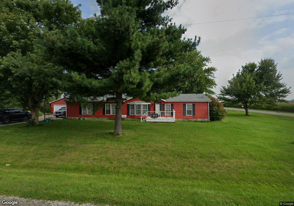
4312 E Airport Rd Urbana, IL 61802
Estimated Value: $181,534 - $230,000
3
Beds
3
Baths
--
Sq Ft
0.56
Acres
About This Home
This home is located at 4312 E Airport Rd, Urbana, IL 61802 and is currently estimated at $205,384. 4312 E Airport Rd is a home located in Champaign County with nearby schools including Thomas Paine Elementary School, Urbana Middle School, and Urbana High School.
Ownership History
Date
Name
Owned For
Owner Type
Purchase Details
Closed on
Sep 7, 2022
Sold by
Richardson Philip G
Bought by
Mcdade Jessica and Heck Cindy R
Current Estimated Value
Home Financials for this Owner
Home Financials are based on the most recent Mortgage that was taken out on this home.
Original Mortgage
$124,699
Outstanding Balance
$119,183
Interest Rate
5.3%
Mortgage Type
FHA
Estimated Equity
$86,201
Purchase Details
Closed on
Mar 15, 2017
Sold by
Richardson Phil
Bought by
Lambert Teresa
Purchase Details
Closed on
Jan 28, 2008
Sold by
First National Bank Of Danville
Bought by
Richardson Philip G
Purchase Details
Closed on
Jan 4, 2008
Sold by
Haywood John Dillon
Bought by
First National Bank Of Danville
Create a Home Valuation Report for This Property
The Home Valuation Report is an in-depth analysis detailing your home's value as well as a comparison with similar homes in the area
Home Values in the Area
Average Home Value in this Area
Purchase History
| Date | Buyer | Sale Price | Title Company |
|---|---|---|---|
| Mcdade Jessica | $127,000 | -- | |
| Lambert Teresa | -- | None Available | |
| Richardson Philip G | $85,500 | None Available | |
| First National Bank Of Danville | -- | None Available |
Source: Public Records
Mortgage History
| Date | Status | Borrower | Loan Amount |
|---|---|---|---|
| Open | Mcdade Jessica | $124,699 |
Source: Public Records
Tax History Compared to Growth
Tax History
| Year | Tax Paid | Tax Assessment Tax Assessment Total Assessment is a certain percentage of the fair market value that is determined by local assessors to be the total taxable value of land and additions on the property. | Land | Improvement |
|---|---|---|---|---|
| 2024 | $3,678 | $55,600 | $9,680 | $45,920 |
| 2023 | $3,678 | $52,060 | $9,060 | $43,000 |
| 2022 | $3,486 | $48,740 | $8,480 | $40,260 |
| 2021 | $3,290 | $46,420 | $8,080 | $38,340 |
| 2020 | $3,171 | $44,940 | $7,820 | $37,120 |
| 2019 | $2,991 | $43,630 | $7,590 | $36,040 |
| 2018 | $2,910 | $42,900 | $7,460 | $35,440 |
| 2017 | $2,872 | $40,850 | $7,100 | $33,750 |
| 2016 | $2,767 | $39,740 | $6,910 | $32,830 |
| 2015 | $2,678 | $38,290 | $6,660 | $31,630 |
| 2014 | $2,629 | $38,290 | $6,660 | $31,630 |
| 2013 | $2,587 | $38,290 | $6,660 | $31,630 |
Source: Public Records
Map
Nearby Homes
- 2808 N Brickhouses Rd
- 3411 E Airport Rd
- 3008 N Brickhouses Rd
- 701 N High Cross Rd
- 1651 Phillips Woods Ln
- 1801 Cindy Lynn St
- 1802 N Concord Ln
- 2709 Boulder Dr
- 2601 S High Cross Rd
- 2202 E Windsor Rd
- 2810 Boulder Dr
- 3001 E Anthony Dr
- 602 N Beacon Hill Cir
- 612 N Beacon Hill Cir
- 610 N Beacon Hill Cir
- 509 N Beacon Hill Cir
- 507 N Beacon Hill Cir
- 505 N Beacon Hill Cir
- 704 N Beacon Hill Cir
- 706 N Beacon Hill Cir
- 2807 N Cottonwood Rd
- 4304 E Airport Rd
- 2811 N Cottonwood Rd
- 2815 N Cottonwood Rd
- 4210 E Airport Rd
- 2901 N Cottonwood Rd
- 2913 N Cottonwood Rd
- 3003 N Cottonwood Rd
- 3009 N Cottonwood Rd
- 2508 N Cottonwood Rd
- 3105 N Cottonwood Rd
- 2407 N Cottonwood Rd
- 4011 E Airport Rd
- 4007 E Airport Rd
- 3113 N Cottonwood Rd
- 3207 N Cottonwood Rd
- 3211 N Cottonwood Rd
- 2213 N Cottonwood Rd
- 3213 N Cottonwood Rd
- 4207 E Oaks Rd