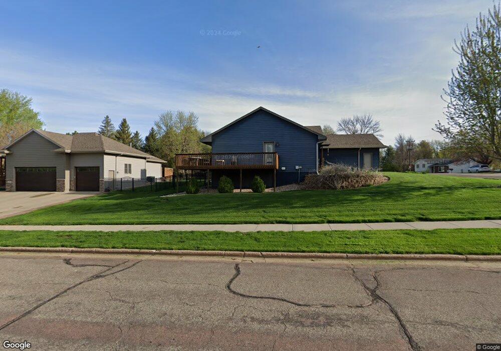
4313 S Lewis Ave Sioux Falls, SD 57103
Tuthill NeighborhoodEstimated Value: $333,000 - $486,000
--
Bed
3
Baths
1,558
Sq Ft
$258/Sq Ft
Est. Value
About This Home
This home is located at 4313 S Lewis Ave, Sioux Falls, SD 57103 and is currently estimated at $401,310, approximately $257 per square foot. 4313 S Lewis Ave is a home located in Minnehaha County with nearby schools including John Harris Elementary School, Patrick Henry Middle School, and Lincoln High School.
Ownership History
Date
Name
Owned For
Owner Type
Purchase Details
Closed on
Sep 23, 2013
Sold by
Austad Homes Inc
Bought by
Erickson Eric and Erickson Loree
Current Estimated Value
Home Financials for this Owner
Home Financials are based on the most recent Mortgage that was taken out on this home.
Original Mortgage
$226,047
Outstanding Balance
$169,746
Interest Rate
4.56%
Mortgage Type
Stand Alone First
Estimated Equity
$231,564
Purchase Details
Closed on
Apr 24, 2013
Sold by
Erickson Eric and Erickson Loree
Bought by
Austad Homes Inc
Create a Home Valuation Report for This Property
The Home Valuation Report is an in-depth analysis detailing your home's value as well as a comparison with similar homes in the area
Home Values in the Area
Average Home Value in this Area
Purchase History
| Date | Buyer | Sale Price | Title Company |
|---|---|---|---|
| Erickson Eric | $282,559 | Getty Abstract & Title Compa | |
| Austad Homes Inc | -- | -- | |
| Erickson Eric | -- | -- |
Source: Public Records
Mortgage History
| Date | Status | Borrower | Loan Amount |
|---|---|---|---|
| Open | Erickson Eric | $226,047 |
Source: Public Records
Tax History
| Year | Tax Paid | Tax Assessment Tax Assessment Total Assessment is a certain percentage of the fair market value that is determined by local assessors to be the total taxable value of land and additions on the property. | Land | Improvement |
|---|---|---|---|---|
| 2024 | $4,485 | $334,100 | $36,800 | $297,300 |
| 2023 | $5,599 | $403,900 | $36,800 | $367,100 |
| 2022 | $5,766 | $392,900 | $36,800 | $356,100 |
| 2021 | $5,424 | $358,600 | $0 | $0 |
| 2020 | $5,424 | $355,300 | $0 | $0 |
| 2019 | $5,287 | $340,240 | $0 | $0 |
| 2018 | $4,900 | $324,806 | $0 | $0 |
| 2016 | $4,676 | $302,762 | $36,720 | $266,042 |
| 2015 | $4,660 | $290,108 | $34,920 | $255,188 |
| 2014 | $4,479 | $290,108 | $34,920 | $255,188 |
Source: Public Records
Map
Nearby Homes
- 4201 S Lewis Ave
- 1904 E 49th St
- 4004 S Otonka Pass
- 4104 S Hackberry Cir
- 4912 S Kalen Place
- 5016 S Winston Ln
- 1200 E Tomar Rd
- 2512 E Winston Cir
- 4505 S Southridge Dr
- 4513 S Southridge Dr
- 2801 E Worcester Place
- 1604 E 62nd St
- 4500 S Tomar Rd
- 5425 S Salvation Place
- 804 E 57th St
- 2716 E Tranquility Place
- 2705 E Tranquility Place
- 2520 E Whisper Trail
- 2401 E Joshua Cir
- 2403 E Joshua Cir
- 1904 E 52nd St
- 4309 S Lewis Ave
- 4308 S Lewis Ave
- 4401 S Lewis Ave
- 1905 E 52nd St
- 4305 S Lewis Ave
- 4304 S Lewis Ave
- 4304 S Highland Ave
- 4312 S Lewis Ave
- 1901 E 52nd St
- 4216 S Thunderbird Trail
- 4405 S Lewis Ave
- 4300 S Lewis Ave
- 4301 S Lewis Ave
- 4220 S Thunderbird Trail
- 4212 S Thunderbird Trail
- 4404 S Highland Ave
- 2000 E 52nd St
- 4213 S Lewis Ave
- 2005 E 51st St
Your Personal Tour Guide
Ask me questions while you tour the home.