


4314 Lumsden Battery Cir W Mobile, AL 36619
Nevius NeighborhoodEstimated payment $974/month
Highlights
- Open-Concept Dining Room
- Corner Lot
- Home Office
- Ranch Style House
- Neighborhood Views
- Covered Patio or Porch
About This Home
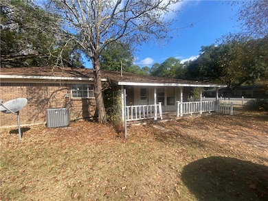
Welcome to 4314 Lumsden Battery Circle—a 3-bedroom, 2-bath home situated on a desirable corner lot and offering nearly 2,000 sq. ft. of living space.
Enjoy a fenced backyard perfect for pets, gatherings, or outdoor relaxation. The property also includes a one-car detached garage, providing ample parking and storage. Conveniently located near shopping, dining, and quick access to I-10. Call your favorite REALTOR® today to schedule a private showing.
Property may be subject to the Alabama One-Year Right of Redemption.
Home Details
Home Type
- Single Family
Est. Annual Taxes
- $1,234
Year Built
- Built in 1974
Lot Details
- 0.4 Acre Lot
- Back Yard Fenced
- Corner Lot
Parking
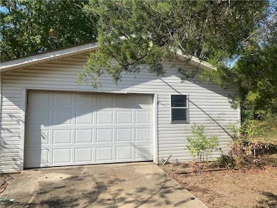
- 1 Car Detached Garage
- Driveway
Home Design
- Ranch Style House
- Slab Foundation
- Shingle Roof
- Four Sided Brick Exterior Elevation
Interior Spaces
- 1,953 Sq Ft Home
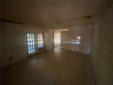
- Living Room
- Open-Concept Dining Room
- Home Office
- Ceramic Tile Flooring
- Neighborhood Views
Kitchen
- Breakfast Bar
- Electric Oven
- Dishwasher
Bedrooms and Bathrooms
- 3 Main Level Bedrooms
- 2 Full Bathrooms
Outdoor Features
- Covered Patio or Porch
Utilities
- Central Heating and Cooling System
- 110 Volts
Community Details
- Wilder Estates Subdivision
Listing and Financial Details
- Assessor Parcel Number 3305211001041
Map
Home Values in the Area
Average Home Value in this Area
Tax History
| Year | Tax Paid | Tax Assessment Tax Assessment Total Assessment is a certain percentage of the fair market value that is determined by local assessors to be the total taxable value of land and additions on the property. | Land | Improvement |
|---|---|---|---|---|
| 2024 | $1,234 | $25,440 | $3,000 | $22,440 |
| 2023 | $1,354 | $25,380 | $3,000 | $22,380 |
| 2022 | $1,132 | $23,340 | $3,000 | $20,340 |
| 2021 | $1,099 | $22,660 | $3,000 | $19,660 |
| 2020 | $1,099 | $11,330 | $1,500 | $9,830 |
| 2019 | $1,078 | $22,220 | $0 | $0 |
| 2018 | $1,052 | $21,700 | $0 | $0 |
| 2017 | $1,052 | $21,700 | $0 | $0 |
| 2016 | $1,012 | $20,860 | $0 | $0 |
| 2013 | -- | $10,620 | $0 | $0 |
Property History
| Date | Event | Price | List to Sale | Price per Sq Ft |
|---|---|---|---|---|
| 11/18/2025 11/18/25 | For Sale | $164,900 | -- | $84 / Sq Ft |
Purchase History
| Date | Type | Sale Price | Title Company |
|---|---|---|---|
| Trustee Deed | $129,837 | None Listed On Document |
Source: Gulf Coast MLS (Mobile Area Association of REALTORS®)
MLS Number: 7682936
APN: 33-05-21-1-001-041
Disclaimer: Certain information contained herein is derived from information provided by parties other than Homes.com. All information provided is deemed reliable, but is not guaranteed to be accurate and should be independently verified.
![]() IDX information is provided exclusively for personal, non-commercial use, and may not be used for any purpose other than to identify prospective properties consumers may be interested in purchasing. Information is deemed reliable but not guaranteed.
IDX information is provided exclusively for personal, non-commercial use, and may not be used for any purpose other than to identify prospective properties consumers may be interested in purchasing. Information is deemed reliable but not guaranteed.
- 6001 Camp Halls Mill Rd
- 4244 Lumsden Battery Cir W
- 5903 Lumsden Battery Cir N
- 4351 Windy Hill Cir E
- 4226 Volta Dr
- 4317 Barden Ave
- 4630 General Rd
- 5623 Holden Dr
- 5835 Andrew Rd
- 0 Stone Mill Ct Unit 7261954
- 4570 Schimpfs Ln
- 0 Stone Mill Dr Unit 6 372203
- 0 Stone Mill Dr Unit 7570233
- 0 Stone Mill Dr Unit 7322129
- 0 Stone Mill Dr Unit 9 381415
- 0 Three Notch Rd Unit 7518762
- 5040 Freeway Dr
- 5023 Freeway Ln
- 5015 Santos Dr W
- 4004 Isabel Way E
- 4850 General Rd
- 5725 Old Pascagoula Rd
- 5675 Old Pascagoula Rd
- 6190 Girby Rd
- 3400 Lloyd's Ln
- 6240 Old Pascagoula Rd
- 6204 Old Pascagoula Rd
- 5799 Southland Dr
- 5089 Government Blvd
- 4950 Government Blvd
- 3205 Lloyds Ln
- 6333 Ironwood Ct
- 5640 Mounthill Ct Unit A
- 4752 Halls Mill Rd
- 5318 Knollwood Ct
- 6134 Stream Bank Dr
- 6147 Stream Bank Dr
- 3105 Demetropolis Rd
- 5412 Timberlane Dr
- 4368 Fathbrook Ln
