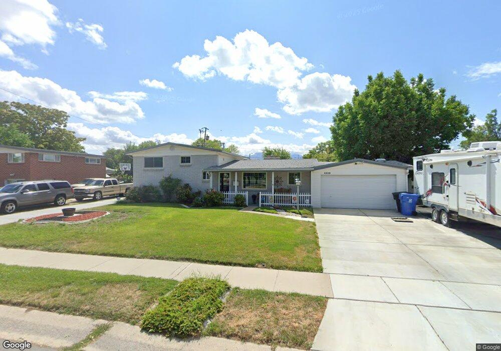
4319 Phillips Ln Salt Lake City, UT 84123
Estimated Value: $448,000 - $472,991
3
Beds
2
Baths
1,288
Sq Ft
$356/Sq Ft
Est. Value
About This Home
This home is located at 4319 Phillips Ln, Salt Lake City, UT 84123 and is currently estimated at $457,998, approximately $355 per square foot. 4319 Phillips Ln is a home located in Salt Lake County with nearby schools including John C Fremont Elementary School, Eisenhower Jr High School, and Taylorsville High School.
Ownership History
Date
Name
Owned For
Owner Type
Purchase Details
Closed on
Mar 11, 1994
Sold by
Romney James R and Romney Vicki J
Bought by
Gordon Michael T and Rasmussen Jacqueline D
Current Estimated Value
Home Financials for this Owner
Home Financials are based on the most recent Mortgage that was taken out on this home.
Original Mortgage
$64,900
Interest Rate
7%
Mortgage Type
Purchase Money Mortgage
Create a Home Valuation Report for This Property
The Home Valuation Report is an in-depth analysis detailing your home's value as well as a comparison with similar homes in the area
Home Values in the Area
Average Home Value in this Area
Purchase History
| Date | Buyer | Sale Price | Title Company |
|---|---|---|---|
| Gordon Michael T | -- | -- |
Source: Public Records
Mortgage History
| Date | Status | Borrower | Loan Amount |
|---|---|---|---|
| Closed | Gordon Michael T | $64,900 |
Source: Public Records
Tax History Compared to Growth
Tax History
| Year | Tax Paid | Tax Assessment Tax Assessment Total Assessment is a certain percentage of the fair market value that is determined by local assessors to be the total taxable value of land and additions on the property. | Land | Improvement |
|---|---|---|---|---|
| 2025 | $2,572 | $438,300 | $100,500 | $337,800 |
| 2024 | $2,572 | $421,800 | $96,200 | $325,600 |
| 2023 | $2,407 | $377,100 | $92,500 | $284,600 |
| 2022 | $2,299 | $373,000 | $90,700 | $282,300 |
| 2021 | $2,157 | $304,800 | $69,800 | $235,000 |
| 2020 | $2,021 | $270,300 | $62,000 | $208,300 |
| 2019 | $2,007 | $262,100 | $62,000 | $200,100 |
| 2018 | $1,834 | $230,900 | $62,000 | $168,900 |
| 2017 | $1,640 | $217,000 | $59,000 | $158,000 |
| 2016 | $1,465 | $193,800 | $59,000 | $134,800 |
| 2015 | $1,409 | $174,200 | $74,400 | $99,800 |
| 2014 | $1,344 | $163,100 | $70,500 | $92,600 |
Source: Public Records
Map
Nearby Homes
- 4288 S 1300 W
- 4250 Chegwidden Ln
- 4249 S Gloucester Ct
- 1219 W Middlesex Rd
- 1218 W 4365 S Unit 4B
- 4332 S 1195 W Unit 18D
- 4259 Dunmore Ct
- 1191 W 4300 S Unit 15A
- 1472 Olive St
- 4255 S Redwood Rd W
- 4176 S Oak Meadows Dr Unit 10
- 4188 S Oak Meadows Dr Unit 21
- 1167 W 4300 S Unit 27C
- 4545 S Thornwood Ave
- 4470 S Summerwood St
- 4148 S Oak Meadows Dr Unit 31
- 4450 S 1175 W
- 4480 S Atherton Dr Unit 22
- 4292 El Camino St
- 1762 Mantle Ave
- 4329 S Phillips Ln
- 4329 Phillips Ln
- 4313 Phillips Ln
- 4334 Fernwood Dr
- 4326 Fernwood Dr
- 4342 Fernwood Dr
- 4326 S Fernwood Dr
- 4320 Mackay St
- 1414 Atherton Dr
- 1414 W Atherton Dr
- 4305 Phillips Ln
- 4309 Mackay St
- 1402 Atherton Dr
- 4318 Fernwood Dr
- 4330 Phillips Ln
- 4308 Mackay St
- 4299 Phillips Ln
- 1363 Varden Way
- 1363 W Varden Way
- 4303 S Mackay St