Estimated Value: $116,000 - $165,000
3
Beds
1
Bath
1,632
Sq Ft
$81/Sq Ft
Est. Value
About This Home
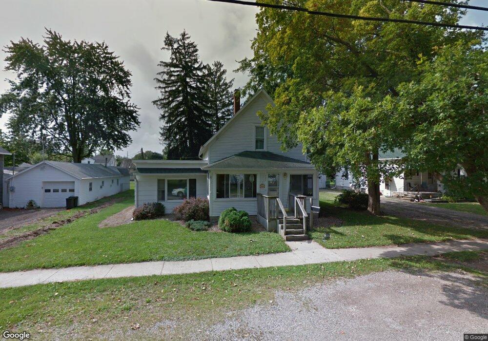
This home is located at 432 E Maple St, Bryan, OH 43506 and is currently estimated at $132,319, approximately $81 per square foot. 432 E Maple St is a home located in Williams County with nearby schools including Bryan Elementary PK-5, Washington Elementary School, and Bryan Middle School/High School.
Ownership History
Date
Name
Owned For
Owner Type
Purchase Details
Closed on
Jun 13, 2007
Sold by
Brust Ronald D and Sines Lorie Ann
Bought by
Motter David J
Current Estimated Value
Home Financials for this Owner
Home Financials are based on the most recent Mortgage that was taken out on this home.
Original Mortgage
$61,750
Interest Rate
6.37%
Mortgage Type
Purchase Money Mortgage
Purchase Details
Closed on
May 16, 2007
Sold by
Ross Keith and Ross Dana
Bought by
Brust Ronald D and Sines Lorie All
Home Financials for this Owner
Home Financials are based on the most recent Mortgage that was taken out on this home.
Original Mortgage
$61,750
Interest Rate
6.37%
Mortgage Type
Purchase Money Mortgage
Purchase Details
Closed on
Oct 1, 2003
Sold by
Brust Ronald Dean And
Bought by
Ross Brust C and Ross Keith O
Purchase Details
Closed on
May 25, 1994
Bought by
Brust Ronald Dean And
Create a Home Valuation Report for This Property
The Home Valuation Report is an in-depth analysis detailing your home's value as well as a comparison with similar homes in the area
Home Values in the Area
Average Home Value in this Area
Purchase History
| Date | Buyer | Sale Price | Title Company |
|---|---|---|---|
| Motter David J | $65,000 | Upland Title Agency Llc | |
| Brust Ronald D | -- | None Available | |
| Ross Brust C | $80,000 | -- | |
| Brust Ronald Dean And | $48,000 | -- |
Source: Public Records
Mortgage History
| Date | Status | Borrower | Loan Amount |
|---|---|---|---|
| Closed | Motter David J | $61,750 |
Source: Public Records
Tax History
| Year | Tax Paid | Tax Assessment Tax Assessment Total Assessment is a certain percentage of the fair market value that is determined by local assessors to be the total taxable value of land and additions on the property. | Land | Improvement |
|---|---|---|---|---|
| 2025 | $1,503 | $33,390 | $5,320 | $28,070 |
| 2024 | $1,503 | $33,390 | $5,320 | $28,070 |
| 2023 | $1,518 | $26,740 | $5,460 | $21,280 |
| 2022 | $1,348 | $26,740 | $5,460 | $21,280 |
| 2021 | $1,347 | $26,740 | $5,460 | $21,280 |
| 2020 | $1,175 | $22,480 | $4,590 | $17,890 |
| 2019 | $1,159 | $22,480 | $4,590 | $17,890 |
| 2018 | $1,121 | $22,480 | $4,590 | $17,890 |
| 2017 | $1,134 | $21,880 | $4,590 | $17,290 |
| 2016 | $1,084 | $21,880 | $4,590 | $17,290 |
| 2015 | $1,133 | $21,880 | $4,590 | $17,290 |
| 2014 | $1,133 | $21,880 | $4,590 | $17,290 |
| 2013 | $1,133 | $21,880 | $4,590 | $17,290 |
Source: Public Records
Map
Nearby Homes
- 404 E Wilson St
- 422 S Main St
- 216 N Allen St
- 0 Lynn St Unit 6110702
- 716 S Walnut St
- 315 N Williams St
- 319 N Williams St
- 128 N Beech St
- 330 N Emmett St
- 542 S Beech St
- 821 S Main St
- 228 N Beech St
- 000 N Main St
- 310 E Edgerton St
- 323 E South St
- 411 E South St
- 425 Oakwood Ave
- 412 Center St
- 000 C R C (West 828)
- 000 C R C (East 787)
- 438 E Maple St
- 428 E Maple St
- 304 S Allen St
- 424 E Maple St
- 433 E Maple St
- 435 E Wilson St
- 318 S Allen St
- 437 E Wilson St
- 429 E Wilson St
- 414 E Maple St
- 425 E Maple St
- 423 E Wilson St
- 320 S Allen St
- 427 E Maple St
- 412 E Maple St
- 502 E Maple St
- 417 E Wilson St
- 307 S Allen St
- 233 S Allen St
- 315 S Allen St
Your Personal Tour Guide
Ask me questions while you tour the home.