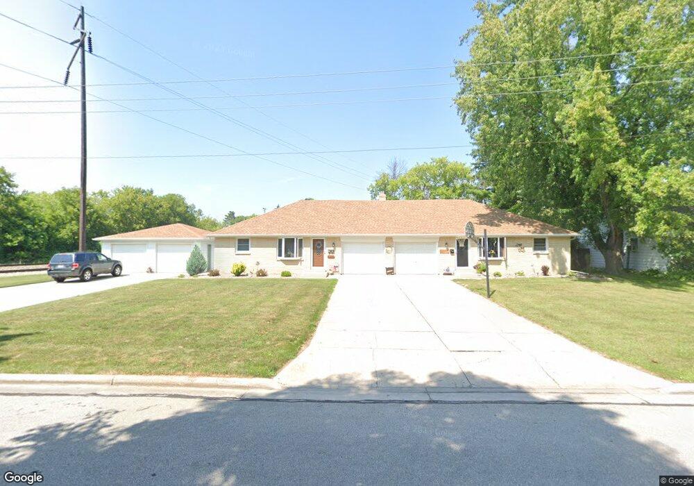
432 Lilac Ln Unit 434 de Pere, WI 54115
Estimated Value: $374,000 - $410,000
--
Bed
4
Baths
2,464
Sq Ft
$160/Sq Ft
Est. Value
About This Home
This home is located at 432 Lilac Ln Unit 434, de Pere, WI 54115 and is currently estimated at $394,436, approximately $160 per square foot. 432 Lilac Ln Unit 434 is a home located in Brown County with nearby schools including Westwood Elementary School, West De Pere Middle School, and West De Pere High School.
Ownership History
Date
Name
Owned For
Owner Type
Purchase Details
Closed on
Aug 12, 2016
Sold by
Ambrosius Beatrice F
Bought by
Ambroslus Beatrice F and Beatrice F Ambroslus Survivor S Trust
Current Estimated Value
Purchase Details
Closed on
Oct 5, 2010
Sold by
Bradley Mark J
Bought by
Ambrosius Roy and Ambrosius Beatrice
Purchase Details
Closed on
May 10, 2010
Sold by
Demoulin Kenneth
Bought by
Demoulin Kenneth D and Kenneth D De Moulin Trust
Create a Home Valuation Report for This Property
The Home Valuation Report is an in-depth analysis detailing your home's value as well as a comparison with similar homes in the area
Home Values in the Area
Average Home Value in this Area
Purchase History
| Date | Buyer | Sale Price | Title Company |
|---|---|---|---|
| Ambroslus Beatrice F | -- | None Available | |
| Ambrosius Roy | -- | None Available | |
| Demoulin Kenneth D | -- | None Available |
Source: Public Records
Tax History Compared to Growth
Tax History
| Year | Tax Paid | Tax Assessment Tax Assessment Total Assessment is a certain percentage of the fair market value that is determined by local assessors to be the total taxable value of land and additions on the property. | Land | Improvement |
|---|---|---|---|---|
| 2024 | $5,316 | $366,000 | $41,800 | $324,200 |
| 2023 | $4,676 | $313,000 | $41,800 | $271,200 |
| 2022 | $4,734 | $283,600 | $41,800 | $241,800 |
| 2021 | $4,548 | $250,400 | $34,900 | $215,500 |
| 2020 | $4,623 | $235,900 | $34,900 | $201,000 |
| 2019 | $4,259 | $219,900 | $34,900 | $185,000 |
| 2018 | $4,165 | $207,800 | $34,900 | $172,900 |
| 2017 | $3,815 | $184,900 | $34,900 | $150,000 |
| 2016 | $3,826 | $184,900 | $34,900 | $150,000 |
| 2015 | $4,241 | $194,300 | $34,900 | $159,400 |
| 2014 | $4,235 | $194,300 | $34,900 | $159,400 |
| 2013 | $4,235 | $194,300 | $34,900 | $159,400 |
Source: Public Records
Map
Nearby Homes
- 806 4th St
- 717 4th St
- 634 Grant St
- 1410 S 7th St
- 978 Saint Anthony Dr Unit 2
- 978 Saint Anthony Dr Unit 980
- 1509 S 7th St
- 555 Main Ave Unit 110
- 555 Main Ave Unit 104
- 555 Main Ave Unit 111
- 555 Main Ave Unit 206
- 555 Main Ave Unit 113
- 1002 Aldrin St
- 657 Reid St
- 235 Autumn Dr
- 830 S Superior St Unit 832
- 1734 Revere Trail
- 721 Cedar St
- 0 N Stellita Cir Unit 50263856
- 0 N Stellita Cir Unit 50263853