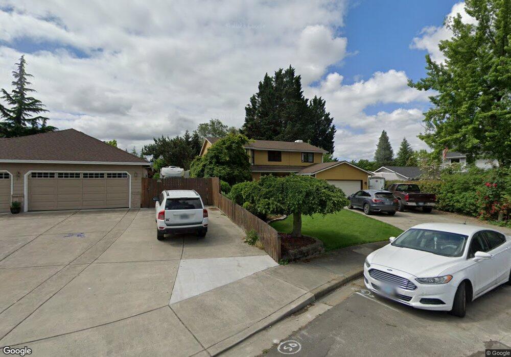
432 Silverado Cir Medford, OR 97504
Estimated Value: $516,000 - $555,000
4
Beds
3
Baths
2,464
Sq Ft
$214/Sq Ft
Est. Value
About This Home
This home is located at 432 Silverado Cir, Medford, OR 97504 and is currently estimated at $528,366, approximately $214 per square foot. 432 Silverado Cir is a home located in Jackson County with nearby schools including Hoover Elementary School, Hedrick Middle School, and South Medford High School.
Ownership History
Date
Name
Owned For
Owner Type
Purchase Details
Closed on
Aug 7, 2025
Sold by
Swan Hillary A
Bought by
Swan Martines Family Trust and Swan
Current Estimated Value
Purchase Details
Closed on
Mar 26, 2013
Sold by
Lumbreras Herbey and Lumbreras Marcel Wanda
Bought by
Swan Hillary
Home Financials for this Owner
Home Financials are based on the most recent Mortgage that was taken out on this home.
Original Mortgage
$214,051
Interest Rate
3.49%
Mortgage Type
FHA
Purchase Details
Closed on
Mar 22, 2011
Sold by
Federal Home Loan Mortgage Corporation
Bought by
Lumbreras Herbey and Lumbreras Marcel Wanda
Home Financials for this Owner
Home Financials are based on the most recent Mortgage that was taken out on this home.
Original Mortgage
$215,397
Interest Rate
4.9%
Mortgage Type
FHA
Purchase Details
Closed on
Nov 15, 2010
Sold by
Freed Lance M and Freed Amy M
Bought by
Federal Home Loan Mortgage Corp
Purchase Details
Closed on
Jul 24, 2006
Sold by
Freed Lance M
Bought by
Freed Lance M and Freed Amy M
Home Financials for this Owner
Home Financials are based on the most recent Mortgage that was taken out on this home.
Original Mortgage
$318,900
Interest Rate
6.57%
Mortgage Type
Unknown
Purchase Details
Closed on
Jul 20, 2006
Sold by
Schmidt John B and Schmidt Priscilla A
Bought by
Freed Lance M
Home Financials for this Owner
Home Financials are based on the most recent Mortgage that was taken out on this home.
Original Mortgage
$318,900
Interest Rate
6.57%
Mortgage Type
Unknown
Purchase Details
Closed on
Dec 10, 1997
Sold by
Anderson Harold A and Anderson Gloria J
Bought by
Schmidt Jonathan B and Schmidt Priscilla A
Home Financials for this Owner
Home Financials are based on the most recent Mortgage that was taken out on this home.
Original Mortgage
$169,087
Interest Rate
7.19%
Mortgage Type
VA
Create a Home Valuation Report for This Property
The Home Valuation Report is an in-depth analysis detailing your home's value as well as a comparison with similar homes in the area
Home Values in the Area
Average Home Value in this Area
Purchase History
| Date | Buyer | Sale Price | Title Company |
|---|---|---|---|
| Swan Martines Family Trust | -- | None Listed On Document | |
| Swan Hillary | $218,000 | First American | |
| Lumbreras Herbey | $221,000 | Service Link | |
| Federal Home Loan Mortgage Corp | $269,000 | None Available | |
| Freed Lance M | -- | Accommodation | |
| Freed Lance M | $414,900 | Lawyers Title Ins | |
| Schmidt Jonathan B | $191,500 | Jackson County Title |
Source: Public Records
Mortgage History
| Date | Status | Borrower | Loan Amount |
|---|---|---|---|
| Previous Owner | Swan Hillary | $214,051 | |
| Previous Owner | Lumbreras Herbey | $215,397 | |
| Previous Owner | Freed Lance M | $318,900 | |
| Previous Owner | Schmidt Jonathan B | $169,087 |
Source: Public Records
Tax History Compared to Growth
Tax History
| Year | Tax Paid | Tax Assessment Tax Assessment Total Assessment is a certain percentage of the fair market value that is determined by local assessors to be the total taxable value of land and additions on the property. | Land | Improvement |
|---|---|---|---|---|
| 2025 | $4,919 | $339,200 | $83,430 | $255,770 |
| 2024 | $4,919 | $329,330 | $81,000 | $248,330 |
| 2023 | $4,769 | $319,740 | $78,640 | $241,100 |
| 2022 | $4,652 | $319,740 | $78,640 | $241,100 |
| 2021 | $4,532 | $310,430 | $76,350 | $234,080 |
| 2020 | $4,436 | $301,390 | $74,130 | $227,260 |
| 2019 | $4,331 | $284,100 | $69,870 | $214,230 |
| 2018 | $4,220 | $275,830 | $67,830 | $208,000 |
| 2017 | $4,144 | $275,830 | $67,830 | $208,000 |
| 2016 | $4,171 | $260,000 | $63,930 | $196,070 |
| 2015 | $4,010 | $260,000 | $63,930 | $196,070 |
| 2014 | $3,939 | $245,080 | $60,260 | $184,820 |
Source: Public Records
Map
Nearby Homes
- 2556 Dellwood Ave
- 325 Sutter Ave
- 349 Tan Oak Dr
- 1300 E Barnett Rd
- 3595 E Barnett Rd
- 2549 E Barnett Rd
- 543 Hoover Park Dr
- 425 S Modoc Ave
- 826 Morrison Ave
- 2741 Ruth Dr
- 3371 Calle Vista Dr
- 754 Fernwood Dr
- 872 Morrison Ave
- 3178 Century Way
- 602 Summerwood Dr
- 908 Black Oak Dr
- 101 S Modoc Ave
- 604 Summerwood Dr
- 91 Black Oak Dr
- 606 Summerwood Dr
- 436 Silverado Cir
- 428 Silverado Cir
- 2609 Siskiyou Blvd
- 2617 Siskiyou Blvd
- 424 Silverado Cir
- 2613 Siskiyou Blvd
- 2625 Siskiyou Blvd
- 421 Silverado Cir
- 420 Silverado Cir
- 2607 Siskiyou Blvd
- 446 Silverado Cir
- 441 Silverado Cir
- 451 Sutter Ave
- 2627 Siskiyou Blvd
- 463 Sutter Ave
- 439 Sutter Ave
- 2624 Dellwood Ave
- 2610 Dellwood Ave
- 475 Sutter Ave
- 2821 Seckel Ct