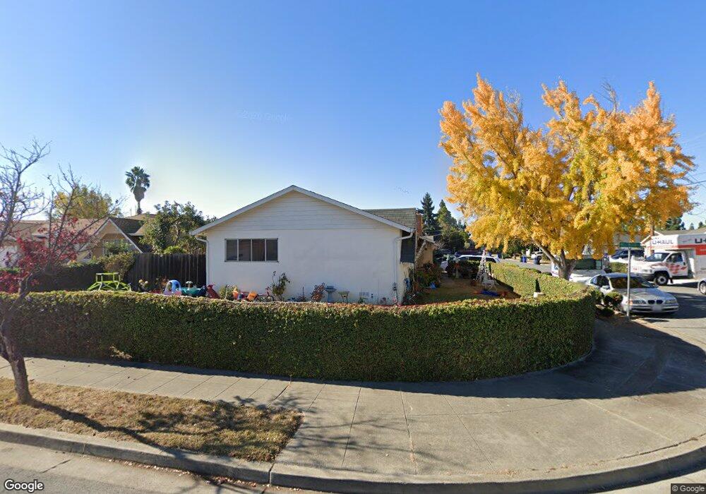
4320 Michael Ave Fremont, CA 94538
Grimmer NeighborhoodEstimated Value: $1,479,538 - $1,637,000
About This Home
This home is located at 4320 Michael Ave, Fremont, CA 94538 and is currently estimated at $1,540,385, approximately $1,267 per square foot. 4320 Michael Ave is a home located in Alameda County with nearby schools including Harvey Green Elementary School, John M. Horner Junior High School, and Irvington High School.
Ownership History
We collect this data history from publicly available records. To have your information removed, we recommend requesting removal directly through your county’s website.
Purchase Details
Home Financials for this Owner
Home Financials are based on the most recent Mortgage that was taken out on this home.Home Values in the Area
Average Home Value in this Area
Purchase History
We collect this data history from publicly available records. To have your information removed, we recommend requesting removal directly through your county’s website.
| Date | Buyer | Sale Price | Title Company |
|---|---|---|---|
| $185,000 | Placer Title Company |
Mortgage History
We collect this data history from publicly available records. To have your information removed, we recommend requesting removal directly through your county’s website.
| Date | Status | Borrower | Loan Amount |
|---|---|---|---|
| Closed | $157,250 |
Tax History
We collect this data history from publicly available records. To have your information removed, we recommend requesting removal directly through your county’s website.
| Year | Tax Paid | Tax Assessment Tax Assessment Total Assessment is a certain percentage of the fair market value that is determined by local assessors to be the total taxable value of land and additions on the property. | Land | Improvement |
|---|---|---|---|---|
| 2025 | $4,198 | $303,727 | $93,218 | $217,509 |
| 2024 | $4,198 | $297,635 | $91,390 | $213,245 |
| 2023 | $4,071 | $298,663 | $89,599 | $209,064 |
| 2022 | $3,997 | $285,808 | $87,842 | $204,966 |
| 2021 | $3,903 | $280,067 | $86,120 | $200,947 |
| 2020 | $3,846 | $284,124 | $85,237 | $198,887 |
| 2019 | $3,805 | $278,554 | $83,566 | $194,988 |
| 2018 | $3,727 | $273,092 | $81,927 | $191,165 |
| 2017 | $3,634 | $267,738 | $80,321 | $187,417 |
| 2016 | $3,561 | $262,490 | $78,747 | $183,743 |
| 2015 | $3,503 | $258,548 | $77,564 | $180,984 |
| 2014 | $3,434 | $253,484 | $76,045 | $177,439 |
Map
- 42663 Hamilton Way
- 41868 Gifford St
- 42552 Roberts Ave
- 4759 Valpey Park Ave
- 42655 Charleston Way
- 4688 Wildwood Park Ct
- 3911 Vicolo Terrace
- 43387 Lindenwood St
- 43225 Mintwood St
- 42657 Newport Dr
- 42348 Blacow Rd
- 3629 Franklin Ave
- 43141 Continental Dr
- 4175 Carol Ave
- 41426 Roberts Ave
- 4032 Doane St
- 42740 Jefferson St
- 205 Manitoba Terrace
- 257 Manitoba Green
- 41328 Thurston St
- 42675 Bellwood Ct
- 4356 Michael Ave
- 42662 Brantwood Ct
- 4321 Michael Ave
- 4309 Michael Ave
- 42697 Bellwood Ct
- 4333 Michael Ave
- 4266 Michael Ave
- 4267 Michael Ave
- 4345 Michael Ave
- 42676 Bellwood Ct
- 42684 Brantwood Ct
- 42698 Bellwood Ct
- 4255 Michael Ave
- 4357 Michael Ave
- 4284 Bora Bora Ave
- 4298 Bora Bora Ave
- 4266 Bora Bora Ave
- 4308 Bora Bora Ave
- 4266 Bora Bora Ave
Ask me questions while you tour the home.