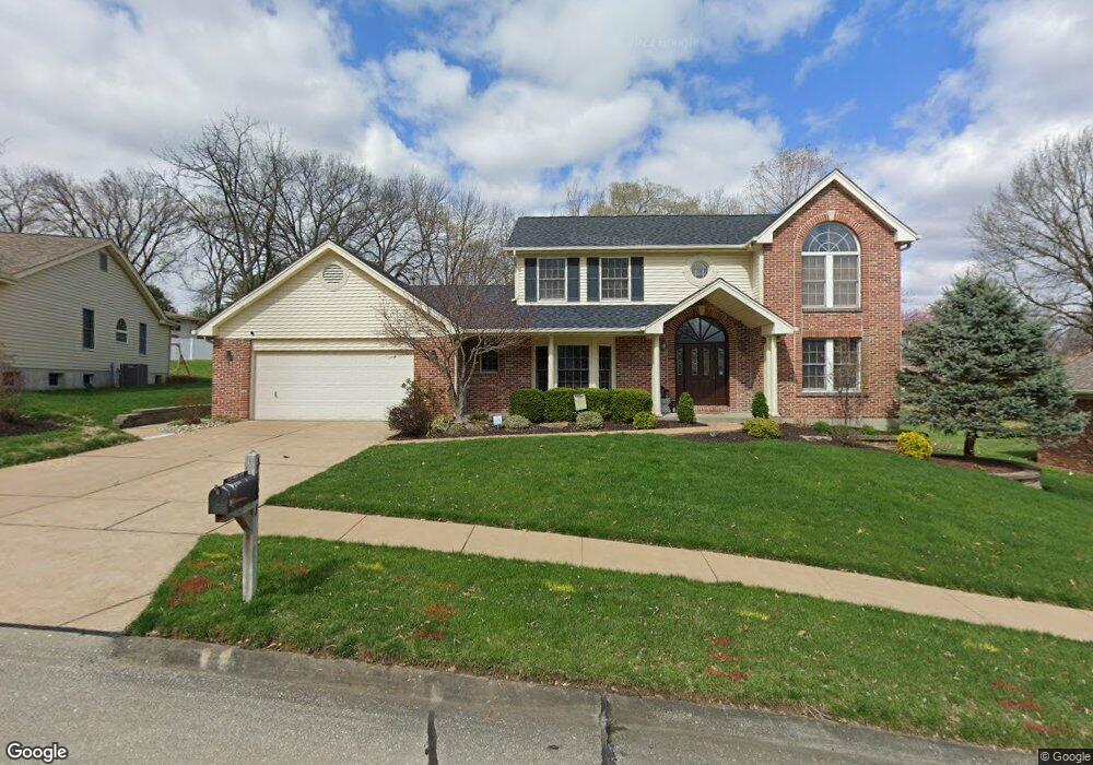
4321 Carrie Beth Ln Saint Louis, MO 63128
Estimated Value: $469,000 - $526,000
4
Beds
3
Baths
2,522
Sq Ft
$195/Sq Ft
Est. Value
About This Home
This home is located at 4321 Carrie Beth Ln, Saint Louis, MO 63128 and is currently estimated at $491,800, approximately $195 per square foot. 4321 Carrie Beth Ln is a home located in St. Louis County with nearby schools including Kennerly Elementary School, Sperreng Middle School, and Lindbergh High School.
Ownership History
Date
Name
Owned For
Owner Type
Purchase Details
Closed on
May 22, 2023
Sold by
Ostendorf Gail A
Bought by
Gail A Ostendorf Living Trust
Current Estimated Value
Purchase Details
Closed on
Dec 13, 2018
Sold by
Ostendorf James J and Ostendorf Gail A
Bought by
Ostendorf Gail A and Ostendorf James J
Purchase Details
Closed on
Nov 24, 1998
Sold by
Ostendorf James J and Ostendorf Gail A
Bought by
Ostendorf James J and Ostendorf Gail A
Create a Home Valuation Report for This Property
The Home Valuation Report is an in-depth analysis detailing your home's value as well as a comparison with similar homes in the area
Home Values in the Area
Average Home Value in this Area
Purchase History
| Date | Buyer | Sale Price | Title Company |
|---|---|---|---|
| Gail A Ostendorf Living Trust | -- | None Listed On Document | |
| Ostendorf Gail A | -- | None Available | |
| Ostendorf James J | -- | -- |
Source: Public Records
Tax History Compared to Growth
Tax History
| Year | Tax Paid | Tax Assessment Tax Assessment Total Assessment is a certain percentage of the fair market value that is determined by local assessors to be the total taxable value of land and additions on the property. | Land | Improvement |
|---|---|---|---|---|
| 2025 | $5,195 | $84,670 | $22,840 | $61,830 |
| 2024 | $5,195 | $79,990 | $20,940 | $59,050 |
| 2023 | $5,182 | $79,990 | $20,940 | $59,050 |
| 2022 | $4,735 | $70,110 | $20,940 | $49,170 |
| 2021 | $4,566 | $70,110 | $20,940 | $49,170 |
| 2020 | $5,257 | $77,950 | $19,300 | $58,650 |
| 2019 | $5,244 | $77,950 | $19,300 | $58,650 |
| 2018 | $4,239 | $57,250 | $10,680 | $46,570 |
| 2017 | $4,193 | $57,250 | $10,680 | $46,570 |
| 2016 | $3,126 | $40,430 | $10,680 | $29,750 |
| 2015 | $3,078 | $40,430 | $10,680 | $29,750 |
| 2014 | $3,352 | $43,640 | $17,590 | $26,050 |
Source: Public Records
Map
Nearby Homes
- 4931 Theiss Rd
- 4838 Dorsie Dr
- 11862 E Concord Rd
- 4449 Pinyon Jay Ct
- 4849 Gatesbury Dr
- 12015 Charwick Dr
- 12055 Charwick Dr
- 4829 Vermilion Dr
- 25 Fawnwood Dr
- 4740 Hedgemont Dr
- 4818 Chapel Hill Dr
- 4645 Tauneybrook Dr
- 11673 Rossmoor Ln
- 4700 Theiss Rd
- 4643 Littlebury Dr
- 4642 Theiss Rd
- 5837 Oak Forest Ln
- 10070 Sakura Dr Unit 100070
- 10033 Carolynne Dr
- 10080 Sakura Dr Unit 1
- 4327 Carrie Beth Ln
- 4315 Carrie Beth Ln
- 4326 Brantleigh Heights Ct
- 4318 Brantleigh Heights Ct
- 4326 Carrie Beth Ln
- 4310 Brantleigh Heights Ct
- 4955 Theiss Rd
- 4334 Brantleigh Heights Ct
- 4310 Carrie Beth Ln
- 4949 Theiss Rd
- 4307 Carrie Beth Ln
- 4342 Brantleigh Heights Ct
- 4301 Carrie Beth Ln
- 4917 Patandy Ln
- 4302 Carrie Beth Ln
- 4930 Patandy Ln
- 4302 Brantleigh Heights Ct
- 4911 Patandy Ln
- 4303 Brantleigh Heights Ct
- 4327 Brantleigh Heights Ct