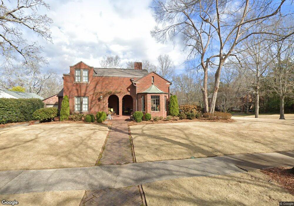
4322 10th Ave S Birmingham, AL 35222
Forest Park NeighborhoodEstimated Value: $633,496 - $740,000
3
Beds
2
Baths
2,389
Sq Ft
$286/Sq Ft
Est. Value
About This Home
This home is located at 4322 10th Ave S, Birmingham, AL 35222 and is currently estimated at $683,624, approximately $286 per square foot. 4322 10th Ave S is a home located in Jefferson County with nearby schools including Avondale Elementary School, W.E. Putnam Middle School Magnet, and Woodlawn High School-Magnet.
Ownership History
Date
Name
Owned For
Owner Type
Purchase Details
Closed on
Sep 19, 2013
Sold by
Marx Edgar B
Bought by
Palazzo Elizabeth and Palazzo Robert
Current Estimated Value
Home Financials for this Owner
Home Financials are based on the most recent Mortgage that was taken out on this home.
Original Mortgage
$286,400
Outstanding Balance
$215,150
Interest Rate
4.57%
Mortgage Type
Commercial
Estimated Equity
$468,474
Create a Home Valuation Report for This Property
The Home Valuation Report is an in-depth analysis detailing your home's value as well as a comparison with similar homes in the area
Home Values in the Area
Average Home Value in this Area
Purchase History
| Date | Buyer | Sale Price | Title Company |
|---|---|---|---|
| Palazzo Elizabeth | $358,000 | -- |
Source: Public Records
Mortgage History
| Date | Status | Borrower | Loan Amount |
|---|---|---|---|
| Open | Palazzo Elizabeth | $286,400 |
Source: Public Records
Tax History Compared to Growth
Tax History
| Year | Tax Paid | Tax Assessment Tax Assessment Total Assessment is a certain percentage of the fair market value that is determined by local assessors to be the total taxable value of land and additions on the property. | Land | Improvement |
|---|---|---|---|---|
| 2024 | $3,831 | $58,740 | -- | -- |
| 2022 | $4,187 | $58,740 | $36,500 | $22,240 |
| 2021 | $3,890 | $54,640 | $36,500 | $18,140 |
| 2020 | $3,830 | $53,820 | $36,500 | $17,320 |
| 2019 | $3,652 | $51,360 | $0 | $0 |
| 2018 | $3,141 | $44,320 | $0 | $0 |
| 2017 | $3,114 | $43,940 | $0 | $0 |
| 2016 | $3,069 | $43,320 | $0 | $0 |
| 2015 | $3,069 | $43,320 | $0 | $0 |
| 2014 | $3,111 | $39,000 | $0 | $0 |
| 2013 | $3,111 | $39,000 | $0 | $0 |
Source: Public Records
Map
Nearby Homes
- 1015 43rd Place S
- 1040 42nd St S Unit B
- 1016 42nd St S Unit A
- 924 Conroy Rd
- 849 42nd St S
- 925 Conroy Rd
- 844 42nd St S
- 4155 Cliff Rd S
- 4350 Cliff Rd S
- 801 Conroy Rd
- 745 Linwood Rd
- 3803 Glenwood Ave
- 917 38th St S
- 4603 Clairmont Ave S
- 3529 Cliff Rd S
- 4309 Linwood Dr
- 712 43rd St S
- 4209 7th Ave S
- 4709 Overwood Cir
- 4300 Linwood Dr
- 4320 10th Ave S
- 4327 Glenwood Ave
- 4301 10th Ave S
- 4326 10th Ave S
- 4322 Glenwood Ave
- 4305 Glenwood Ave
- 4300 10th Ave S
- 4325 10th Ave S
- 4316 Glenwood Ave
- 4301 Glenwood Ave
- 1021 43rd St S
- 4336 10th Ave S
- 4329 10th Ave S
- 4312 Glenwood Ave
- 1010 43rd St S
- 4221 Glenwood Ave
- 1014 43rd St S
- 1000 43rd St S
- 1006 43rd St S
- 4306 Glenwood Ave