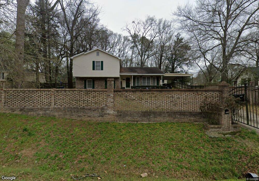
4328 Forrest Rd Columbus, GA 31907
Eastern Columbus NeighborhoodEstimated Value: $182,000 - $208,950
4
Beds
4
Baths
1,867
Sq Ft
$102/Sq Ft
Est. Value
About This Home
This home is located at 4328 Forrest Rd, Columbus, GA 31907 and is currently estimated at $191,238, approximately $102 per square foot. 4328 Forrest Rd is a home located in Muscogee County with nearby schools including Brewer Elementary School, Fort Middle School, and Hardaway High School.
Ownership History
Date
Name
Owned For
Owner Type
Purchase Details
Closed on
Nov 21, 2023
Sold by
Jones Maurice and Jones Sonja L
Bought by
Wade Brenda Lee
Current Estimated Value
Purchase Details
Closed on
May 20, 2010
Sold by
Secretary Of Veterans Affairs
Bought by
Jones Maurice and Jones Sonja L
Purchase Details
Closed on
Oct 6, 2009
Sold by
Bac Home Loans Servicing Lp
Bought by
Secretary Of Veterans Affairs
Create a Home Valuation Report for This Property
The Home Valuation Report is an in-depth analysis detailing your home's value as well as a comparison with similar homes in the area
Home Values in the Area
Average Home Value in this Area
Purchase History
| Date | Buyer | Sale Price | Title Company |
|---|---|---|---|
| Wade Brenda Lee | $30,000 | None Listed On Document | |
| Jones Maurice | $86,000 | None Available | |
| Secretary Of Veterans Affairs | -- | None Available | |
| Bac Home Loans Servicing Lp | $110,162 | None Available |
Source: Public Records
Tax History Compared to Growth
Tax History
| Year | Tax Paid | Tax Assessment Tax Assessment Total Assessment is a certain percentage of the fair market value that is determined by local assessors to be the total taxable value of land and additions on the property. | Land | Improvement |
|---|---|---|---|---|
| 2025 | $4,699 | $68,424 | $12,080 | $56,344 |
| 2024 | $216 | $68,424 | $12,080 | $56,344 |
| 2023 | $2,545 | $64,600 | $12,080 | $52,520 |
| 2022 | $2,182 | $53,440 | $9,084 | $44,356 |
| 2021 | $2,311 | $56,592 | $9,084 | $47,508 |
| 2020 | $2,311 | $56,592 | $9,084 | $47,508 |
| 2019 | $2,319 | $56,592 | $9,084 | $47,508 |
| 2018 | $2,319 | $56,592 | $9,084 | $47,508 |
| 2017 | $2,326 | $56,592 | $9,084 | $47,508 |
| 2016 | $2,106 | $51,047 | $4,866 | $46,181 |
| 2015 | $2,108 | $51,047 | $4,866 | $46,181 |
| 2014 | $2,111 | $51,047 | $4,866 | $46,181 |
| 2013 | -- | $51,047 | $4,866 | $46,181 |
Source: Public Records
Map
Nearby Homes
- 911 Lamore St
- 4332 Fay Dr
- 4201 Forrest Rd
- 4237 Fort St
- 4268 Yates Dr
- 4248 Yates Dr
- 1918 Watkins Dr
- 4312 Old MacOn Rd Unit 6
- 2622 Natchez Dr
- 1674 Forestside Dr
- 4785 Gardiner Dr
- 4418 Gardiner Dr
- 4161 Althea Dr
- 2661 Fernwood Ave
- 4630 Gardiner Dr
- 4160 Spirea Dr
- 2608 Juniper Ave
- 1544 Celia Dr
- 3875 Mulberry Dr
- 2246 Danbury Dr
- 4332 Forrest Rd
- 4314 Forrest Rd
- 4342 Forrest Rd
- 4315 Forrest Rd
- 4312 Forrest Rd
- 4325 Forrest Rd
- 4341 Forrest Rd
- 4309 Forrest Rd
- 4350 Forrest Rd
- 4333 Forrest Rd
- 4304 Forrest Rd
- 907 Lamore St
- 4303 Forrest Rd
- 2124 Reese Rd
- 4347 Forrest Rd
- 2214 Reese Rd
- 4354 Forrest Rd
- 4353 Forrest Rd
- 913 Lamore St
- 915 Lamore St