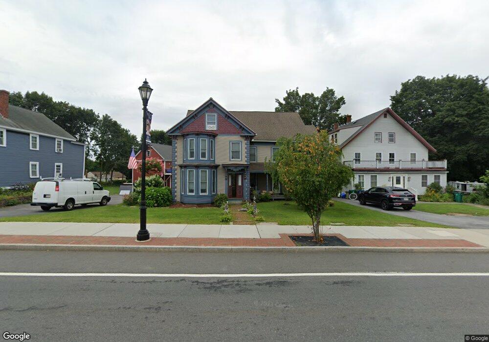
433 Boston Rd Billerica, MA 01821
Estimated Value: $858,000 - $1,032,000
6
Beds
4
Baths
3,695
Sq Ft
$247/Sq Ft
Est. Value
About This Home
This home is located at 433 Boston Rd, Billerica, MA 01821 and is currently estimated at $913,039, approximately $247 per square foot. 433 Boston Rd is a home located in Middlesex County with nearby schools including Billerica Memorial High School.
Ownership History
Date
Name
Owned For
Owner Type
Purchase Details
Closed on
Jul 28, 2010
Sold by
J C Ferola Rt and Ferola
Bought by
Ferola James M and Ferola Collette M
Current Estimated Value
Home Financials for this Owner
Home Financials are based on the most recent Mortgage that was taken out on this home.
Original Mortgage
$219,700
Outstanding Balance
$145,864
Interest Rate
4.78%
Mortgage Type
Purchase Money Mortgage
Estimated Equity
$767,175
Create a Home Valuation Report for This Property
The Home Valuation Report is an in-depth analysis detailing your home's value as well as a comparison with similar homes in the area
Home Values in the Area
Average Home Value in this Area
Purchase History
| Date | Buyer | Sale Price | Title Company |
|---|---|---|---|
| Ferola James M | -- | -- |
Source: Public Records
Mortgage History
| Date | Status | Borrower | Loan Amount |
|---|---|---|---|
| Open | Ferola James M | $219,700 |
Source: Public Records
Tax History Compared to Growth
Tax History
| Year | Tax Paid | Tax Assessment Tax Assessment Total Assessment is a certain percentage of the fair market value that is determined by local assessors to be the total taxable value of land and additions on the property. | Land | Improvement |
|---|---|---|---|---|
| 2025 | $8,864 | $779,600 | $323,500 | $456,100 |
| 2024 | $7,946 | $703,800 | $303,900 | $399,900 |
| 2023 | $7,865 | $662,600 | $262,700 | $399,900 |
| 2022 | $7,224 | $571,500 | $215,700 | $355,800 |
| 2021 | $16,805 | $550,900 | $203,900 | $347,000 |
| 2020 | $12,100 | $543,100 | $196,100 | $347,000 |
| 2019 | $5,835 | $481,600 | $180,400 | $301,200 |
| 2018 | $15,318 | $456,700 | $163,900 | $292,800 |
| 2017 | $6,047 | $429,200 | $156,900 | $272,300 |
| 2016 | $5,756 | $407,100 | $140,400 | $266,700 |
| 2015 | $5,671 | $403,900 | $137,200 | $266,700 |
| 2014 | $5,643 | $394,900 | $136,100 | $258,800 |
Source: Public Records
Map
Nearby Homes
- 10 Charnstaff Ln Unit 204
- 405 Boston Rd Unit 2
- 22 Kenmar Dr Unit 194Y
- 14 Kenmar Dr Unit 111
- 2 Karen Cir Unit 2
- 5 Karen Cir Unit 16
- 1 Purcell Dr
- 396 Boston Rd Unit 103
- 19 Parker St
- 14 Elsie Ave
- 37 Porter St
- 454 Middlesex Turnpike
- 10 Avondale Ave
- 463 Middlesex Turnpike
- 8 Swan Ln
- 79 Bridle Rd
- 481 Middlesex Turnpike
- 483 Middlesex Turnpike
- 91 Pond St
- 81 Salem Rd Unit 102
- 427 Boston Rd Unit 429
- 435 Boston Rd Unit 437
- 423 Boston Rd
- 478 Boston Rd
- 419 Boston Rd
- 474 Boston Rd
- 7 Charnstaff Ln
- 9 Charnstaff Ln
- 415 Boston Rd
- 10 Charnstaff Ln Unit 301
- 10 Charnstaff Ln Unit 205
- 10 Charnstaff Ln Unit 203
- 10 Charnstaff Ln Unit 202
- 10 Charnstaff Ln Unit 201
- 10 Charnstaff Ln Unit 103
- 10 Charnstaff Ln Unit 508
- 10 Charnstaff Ln Unit 507
- 10 Charnstaff Ln Unit 506
- 10 Charnstaff Ln Unit 505
- 10 Charnstaff Ln Unit 504