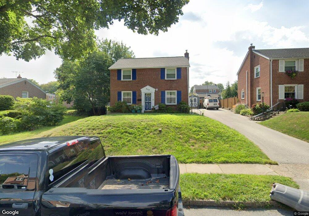
433 Briarhill Rd Springfield, PA 19064
Estimated Value: $386,000 - $442,000
3
Beds
1
Bath
1,416
Sq Ft
$296/Sq Ft
Est. Value
About This Home
This home is located at 433 Briarhill Rd, Springfield, PA 19064 and is currently estimated at $418,472, approximately $295 per square foot. 433 Briarhill Rd is a home located in Delaware County with nearby schools including Springfield High School, St Francis Of Assisi School, and Holy Cross School.
Ownership History
Date
Name
Owned For
Owner Type
Purchase Details
Closed on
Sep 22, 2000
Sold by
Estate Of A Roberta Reeves and Reeves Walter F
Bought by
Spaccarelli Thomas J and Spaccarelli Amy E
Current Estimated Value
Home Financials for this Owner
Home Financials are based on the most recent Mortgage that was taken out on this home.
Original Mortgage
$80,000
Outstanding Balance
$28,868
Interest Rate
7.96%
Estimated Equity
$389,604
Create a Home Valuation Report for This Property
The Home Valuation Report is an in-depth analysis detailing your home's value as well as a comparison with similar homes in the area
Home Values in the Area
Average Home Value in this Area
Purchase History
| Date | Buyer | Sale Price | Title Company |
|---|---|---|---|
| Spaccarelli Thomas J | $100,000 | -- |
Source: Public Records
Mortgage History
| Date | Status | Borrower | Loan Amount |
|---|---|---|---|
| Open | Spaccarelli Thomas J | $80,000 |
Source: Public Records
Tax History
| Year | Tax Paid | Tax Assessment Tax Assessment Total Assessment is a certain percentage of the fair market value that is determined by local assessors to be the total taxable value of land and additions on the property. | Land | Improvement |
|---|---|---|---|---|
| 2025 | $7,642 | $271,900 | $94,840 | $177,060 |
| 2024 | $7,642 | $271,900 | $94,840 | $177,060 |
| 2023 | $7,359 | $271,900 | $94,840 | $177,060 |
| 2022 | $7,200 | $271,900 | $94,840 | $177,060 |
| 2021 | $11,150 | $271,900 | $94,840 | $177,060 |
| 2020 | $5,943 | $131,160 | $45,590 | $85,570 |
| 2019 | $5,804 | $131,160 | $45,590 | $85,570 |
| 2018 | $5,721 | $131,160 | $0 | $0 |
| 2017 | $5,588 | $131,160 | $0 | $0 |
| 2016 | $720 | $131,160 | $0 | $0 |
| 2015 | $720 | $131,160 | $0 | $0 |
| 2014 | $720 | $131,160 | $0 | $0 |
Source: Public Records
Map
Nearby Homes
- 493 Wheatsheaf Rd
- 364 S Rolling Rd
- 31 Wayfield Rd
- 227 E Leamy Ave
- 332 Franklin Ave
- 1299 Country Club Dr Unit Q141
- 1291 Country Club Dr Unit Q137
- 1433 Country Club Dr Unit T214
- 111 Forest Rd
- 226 Lynbrooke Rd
- 147 Snyder Ln
- 933 Greenbriar Ln
- 1588 Nicklaus Dr Unit H65
- 641 W Sproul Rd
- 114 Providence Rd
- 120 W Springfield Rd
- 519 Walnut Ln Unit 1
- 978 Westfield Rd
- 606 W Springfield Rd
- 507 School St
- 437 Briarhill Rd
- 425 Briarhill Rd
- 20 White Oak Rd
- 443 Briarhill Rd
- 432 Wheatsheaf Rd
- 436 Wheatsheaf Rd
- 432 Briarhill Rd
- 428 Briarhill Rd
- 442 Wheatsheaf Rd
- 447 Briarhill Rd
- 438 Briarhill Rd
- 424 Briarhill Rd
- 446 Wheatsheaf Rd
- 442 Briarhill Rd
- 15 White Oak Rd
- 451 Briarhill Rd
- 19 White Oak Rd
- 23 White Oak Rd
- 452 Wheatsheaf Rd
Your Personal Tour Guide
Ask me questions while you tour the home.