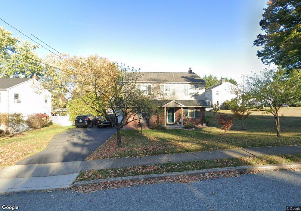
433 Covered Bridge Rd King of Prussia, PA 19406
Estimated Value: $473,000 - $530,420
4
Beds
3
Baths
1,904
Sq Ft
$269/Sq Ft
Est. Value
About This Home
This home is located at 433 Covered Bridge Rd, King of Prussia, PA 19406 and is currently estimated at $511,605, approximately $268 per square foot. 433 Covered Bridge Rd is a home located in Montgomery County with nearby schools including Caley Elementary School, Upper Merion Middle School, and Upper Merion High School.
Ownership History
Date
Name
Owned For
Owner Type
Purchase Details
Closed on
Mar 26, 2024
Sold by
Hoang Tiem D and Hoang Hong A
Bought by
Tiem D Hoang And Hong A Hoang Family Trust and Hoang
Current Estimated Value
Purchase Details
Closed on
Jul 1, 2010
Sold by
Wells Fargo Bank Na
Bought by
Hoang Tiem and Hoang Hong
Purchase Details
Closed on
Jan 25, 2010
Sold by
Ngo Diem T and Kim Giau A
Bought by
Wells Fargo Bank Na
Purchase Details
Closed on
Jul 30, 2003
Sold by
Collins Theodore J Ex and Collins William J Est
Bought by
Kim Giau A and Ngo Diem T
Create a Home Valuation Report for This Property
The Home Valuation Report is an in-depth analysis detailing your home's value as well as a comparison with similar homes in the area
Home Values in the Area
Average Home Value in this Area
Purchase History
| Date | Buyer | Sale Price | Title Company |
|---|---|---|---|
| Tiem D Hoang And Hong A Hoang Family Trust | -- | None Listed On Document | |
| Tiem D Hoang And Hong A Hoang Family Trust | -- | None Listed On Document | |
| Hoang Tiem | $234,822 | None Available | |
| Wells Fargo Bank Na | $240,100 | None Available | |
| Kim Giau A | $257,500 | -- |
Source: Public Records
Tax History Compared to Growth
Tax History
| Year | Tax Paid | Tax Assessment Tax Assessment Total Assessment is a certain percentage of the fair market value that is determined by local assessors to be the total taxable value of land and additions on the property. | Land | Improvement |
|---|---|---|---|---|
| 2025 | $4,755 | $154,280 | $53,410 | $100,870 |
| 2024 | $4,755 | $154,280 | $53,410 | $100,870 |
| 2023 | $4,587 | $154,280 | $53,410 | $100,870 |
| 2022 | $4,390 | $154,280 | $53,410 | $100,870 |
| 2021 | $4,254 | $154,280 | $53,410 | $100,870 |
| 2020 | $4,065 | $154,280 | $53,410 | $100,870 |
| 2019 | $3,996 | $154,280 | $53,410 | $100,870 |
| 2018 | $3,996 | $154,280 | $53,410 | $100,870 |
| 2017 | $3,852 | $154,280 | $53,410 | $100,870 |
| 2016 | $3,792 | $154,280 | $53,410 | $100,870 |
| 2015 | $3,792 | $154,280 | $53,410 | $100,870 |
| 2014 | $3,652 | $154,280 | $53,410 | $100,870 |
Source: Public Records
Map
Nearby Homes
- 735 Champlain Dr
- 345 W Signal Hill Rd
- 245 Chapel Ln Unit 80B
- 251 Chapel Ln Unit 83B
- 243 Chapel Ln Unit 79A
- 548 Susan Dr
- 330 Crossfield Rd
- 394 Stonybrook Rd
- 501 W Dekalb Pike
- 200 Prince Frederick St Unit J3
- 156 Green Hill Rd
- 176 Riversedge Dr
- 143 Riversedge Dr Unit CONDO 143
- 121 Woodstream Dr Unit CONDO 121
- 603 Nantucket Cir
- 612 Brewster Aly Unit 74
- 608 Brewster Aly
- 237 E Valley Forge Rd
- 1914 Yorktown S
- 2012 Yorktown S
- 428 W Valley Forge Rd
- 429 Covered Bridge Rd
- 436 W Valley Forge Rd
- 428 Covered Bridge Rd
- 419 Covered Bridge Rd
- 424 W Valley Forge Rd
- 409 Covered Bridge Rd
- 440 W Valley Forge Rd
- 469 W Valley Forge Rd
- 463 W Valley Forge Rd
- 424 Covered Bridge Rd
- 475 W Valley Forge Rd
- 405 Covered Bridge Rd
- 457 W Valley Forge Rd
- 404 W Valley Forge Rd
- 481 W Valley Forge Rd
- 617 Caley Rd
- 451 W Valley Forge Rd
- 420 Covered Bridge Rd
- 450 W Valley Forge Rd