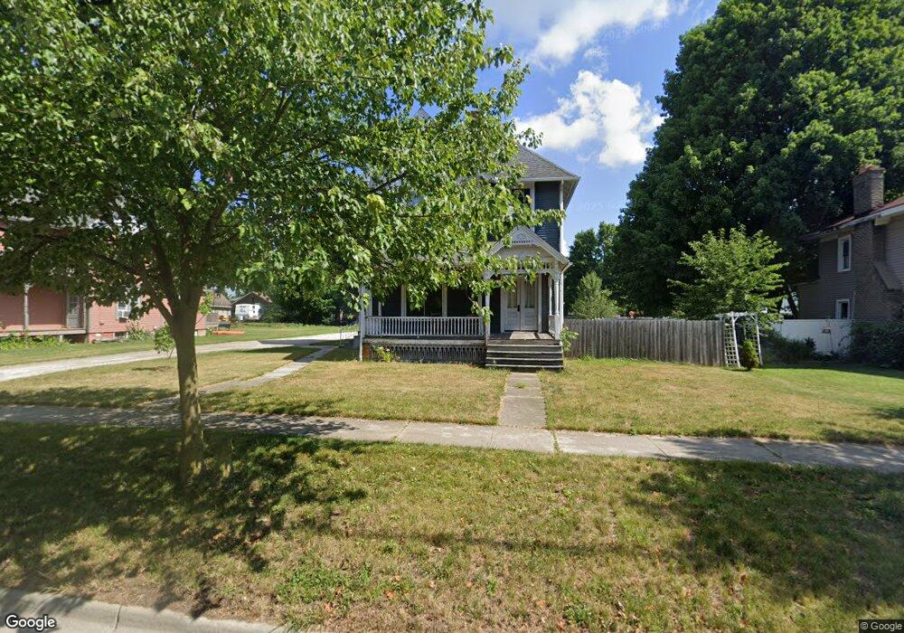
433 E Main St Morenci, MI 49256
Estimated Value: $172,000 - $201,739
3
Beds
2
Baths
2,600
Sq Ft
$71/Sq Ft
Est. Value
About This Home
This home is located at 433 E Main St, Morenci, MI 49256 and is currently estimated at $183,935, approximately $70 per square foot. 433 E Main St is a home located in Lenawee County with nearby schools including Morenci Elementary School and Morenci Middle/High School.
Ownership History
Date
Name
Owned For
Owner Type
Purchase Details
Closed on
Dec 30, 2010
Sold by
Fannie Mae
Bought by
Peters Jeremie D
Current Estimated Value
Home Financials for this Owner
Home Financials are based on the most recent Mortgage that was taken out on this home.
Original Mortgage
$51,855
Outstanding Balance
$34,928
Interest Rate
4.53%
Mortgage Type
New Conventional
Estimated Equity
$149,007
Purchase Details
Closed on
Apr 29, 2010
Sold by
First Federal Bank Of The Midwest
Bought by
Fannie Mae
Purchase Details
Closed on
Mar 18, 2010
Sold by
Decker Richard E and Decker Peggy J
Bought by
Pavillion Mortgage Company
Purchase Details
Closed on
Feb 28, 2004
Bought by
Peters Jeremie D
Create a Home Valuation Report for This Property
The Home Valuation Report is an in-depth analysis detailing your home's value as well as a comparison with similar homes in the area
Home Values in the Area
Average Home Value in this Area
Purchase History
| Date | Buyer | Sale Price | Title Company |
|---|---|---|---|
| Peters Jeremie D | $54,600 | Attornys Title Agency Llc | |
| Fannie Mae | -- | None Available | |
| Pavillion Mortgage Company | $108,468 | None Available | |
| Peters Jeremie D | -- | -- |
Source: Public Records
Mortgage History
| Date | Status | Borrower | Loan Amount |
|---|---|---|---|
| Open | Peters Jeremie D | $51,855 |
Source: Public Records
Tax History
| Year | Tax Paid | Tax Assessment Tax Assessment Total Assessment is a certain percentage of the fair market value that is determined by local assessors to be the total taxable value of land and additions on the property. | Land | Improvement |
|---|---|---|---|---|
| 2025 | $3,564 | $76,200 | $0 | $0 |
| 2024 | $15 | $68,600 | $0 | $0 |
| 2022 | $5,945 | $55,200 | $0 | $0 |
| 2020 | $2,962 | $49,200 | $0 | $0 |
| 2019 | $118,545 | $47,500 | $0 | $0 |
| 2018 | $118,545 | $42,848 | $0 | $0 |
| 2017 | $1,175 | $42,668 | $0 | $0 |
| 2016 | $0 | $41,786 | $0 | $0 |
| 2014 | -- | $38,679 | $0 | $0 |
Source: Public Records
Map
Nearby Homes
- 511 E Main St
- 115 N East St
- 440 Whitney Ave
- 120 S Washington St
- 328 E Main St
- 314 Whitney Ave
- 202 E Locust St
- 402 Pearl St
- 234 E Union St
- 507 Page St
- 518 N East St
- 136 Orchard St
- 136 E Chestnut St
- 210 W Locust St
- 00 Coomer St Unit 9728 Coomer St
- 124 W Walnut Rd
- Block Skyline Dr
- 504 North St
- 945 N Summit St
- 139 Gorham St
Your Personal Tour Guide
Ask me questions while you tour the home.