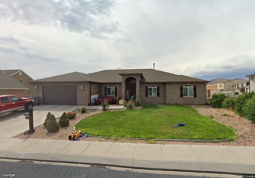
433 N 375 W Enterprise, UT 84725
Estimated Value: $465,000 - $556,000
6
Beds
4
Baths
2,473
Sq Ft
$210/Sq Ft
Est. Value
About This Home
This home is located at 433 N 375 W, Enterprise, UT 84725 and is currently estimated at $518,492, approximately $209 per square foot. 433 N 375 W is a home located in Washington County with nearby schools including Enterprise School and Enterprise High School.
Ownership History
Date
Name
Owned For
Owner Type
Purchase Details
Closed on
Apr 27, 2020
Sold by
Campbell Richard Chase and Campbell Wendi Jeanee
Bought by
Richins Warrin and Richins Nichelle
Current Estimated Value
Home Financials for this Owner
Home Financials are based on the most recent Mortgage that was taken out on this home.
Original Mortgage
$292,500
Outstanding Balance
$259,196
Interest Rate
3.3%
Mortgage Type
New Conventional
Estimated Equity
$259,296
Purchase Details
Closed on
Mar 22, 2019
Sold by
Campbell Richard Chase
Bought by
Campbell Richard Chase and Campbell Wendi Jeanee
Home Financials for this Owner
Home Financials are based on the most recent Mortgage that was taken out on this home.
Original Mortgage
$301,010
Interest Rate
4.4%
Mortgage Type
New Conventional
Purchase Details
Closed on
Oct 7, 2013
Sold by
Desert Valley Development Inc
Bought by
Charles Ryan K and Charles Danielle K
Home Financials for this Owner
Home Financials are based on the most recent Mortgage that was taken out on this home.
Original Mortgage
$235,000
Interest Rate
4.49%
Mortgage Type
New Conventional
Create a Home Valuation Report for This Property
The Home Valuation Report is an in-depth analysis detailing your home's value as well as a comparison with similar homes in the area
Purchase History
| Date | Buyer | Sale Price | Title Company |
|---|---|---|---|
| Richins Warrin | -- | Terra Title Compan | |
| Campbell Richard Chase | -- | Accommodation | |
| Campbell Richard Chase | -- | Eagle Gate Ttl Ins Agcy Inc | |
| Charles Ryan K | -- | Southern Utah Title |
Source: Public Records
Mortgage History
| Date | Status | Borrower | Loan Amount |
|---|---|---|---|
| Open | Richins Warrin | $292,500 | |
| Previous Owner | Campbell Richard Chase | $301,010 | |
| Previous Owner | Charles Ryan K | $235,000 |
Source: Public Records
Tax History
| Year | Tax Paid | Tax Assessment Tax Assessment Total Assessment is a certain percentage of the fair market value that is determined by local assessors to be the total taxable value of land and additions on the property. | Land | Improvement |
|---|---|---|---|---|
| 2025 | $2,111 | $293,535 | $41,250 | $252,285 |
| 2023 | $2,004 | $283,635 | $41,250 | $242,385 |
| 2022 | $2,229 | $300,300 | $41,250 | $259,050 |
| 2021 | $84 | $382,200 | $45,000 | $337,200 |
| 2020 | $1,609 | $299,300 | $35,000 | $264,300 |
| 2019 | $1,629 | $293,900 | $30,000 | $263,900 |
| 2018 | $1,528 | $142,725 | $0 | $0 |
| 2017 | $1,420 | $127,490 | $0 | $0 |
| 2016 | $1,355 | $112,640 | $0 | $0 |
| 2015 | $1,386 | $111,210 | $0 | $0 |
| 2014 | $1,427 | $114,510 | $0 | $0 |
Source: Public Records
Map
Nearby Homes
- 453 N 300 W
- 328 W 475 N
- 232 W 475 N
- 319 N 200 W
- 177 W 350 N
- 120 W 100 St S
- 81 S Center St
- 0 184 77 Acres Unit 25-265059
- 0 184 77 Acres Unit 113074
- 170 E 100 South St
- Financing Miningclaim Ownership
- 373 E 100 N
- 400 E 100 N
- 242 S 200 St E
- 260 E 300 S
- 49 S 475 E Unit 6
- 498 S 75 E
- 231 400 E
- 496 S 200 E
- 246 S 475 E
Your Personal Tour Guide
Ask me questions while you tour the home.