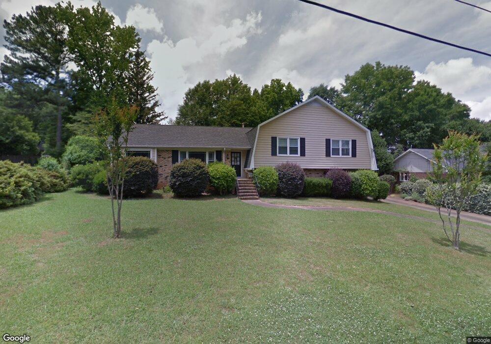
433 Oneal Dr Birmingham, AL 35226
Estimated Value: $401,278 - $436,000
4
Beds
2
Baths
2,072
Sq Ft
$203/Sq Ft
Est. Value
About This Home
This home is located at 433 Oneal Dr, Birmingham, AL 35226 and is currently estimated at $420,820, approximately $203 per square foot. 433 Oneal Dr is a home located in Jefferson County with nearby schools including Gwin Elementary School, Ira F. Simmons Middle School, and Hoover High School.
Ownership History
Date
Name
Owned For
Owner Type
Purchase Details
Closed on
Oct 28, 2004
Sold by
Page Grier P and Page Patricia Z
Bought by
Page Grier P
Current Estimated Value
Home Financials for this Owner
Home Financials are based on the most recent Mortgage that was taken out on this home.
Original Mortgage
$168,000
Outstanding Balance
$79,709
Interest Rate
5.67%
Mortgage Type
Purchase Money Mortgage
Estimated Equity
$341,111
Purchase Details
Closed on
Dec 5, 2001
Sold by
Washington Louis and Washington Pamela G
Bought by
Page Grier P and Page Patricia Z
Home Financials for this Owner
Home Financials are based on the most recent Mortgage that was taken out on this home.
Original Mortgage
$146,300
Interest Rate
6.5%
Create a Home Valuation Report for This Property
The Home Valuation Report is an in-depth analysis detailing your home's value as well as a comparison with similar homes in the area
Home Values in the Area
Average Home Value in this Area
Purchase History
| Date | Buyer | Sale Price | Title Company |
|---|---|---|---|
| Page Grier P | $500 | -- | |
| Page Grier P | $182,900 | -- |
Source: Public Records
Mortgage History
| Date | Status | Borrower | Loan Amount |
|---|---|---|---|
| Open | Page Grier P | $168,000 | |
| Closed | Page Grier P | $146,300 | |
| Closed | Page Grier P | $27,400 |
Source: Public Records
Tax History
| Year | Tax Paid | Tax Assessment Tax Assessment Total Assessment is a certain percentage of the fair market value that is determined by local assessors to be the total taxable value of land and additions on the property. | Land | Improvement |
|---|---|---|---|---|
| 2024 | $2,141 | $30,220 | -- | -- |
| 2022 | $2,192 | $30,920 | $12,300 | $18,620 |
| 2021 | $1,807 | $25,620 | $12,300 | $13,320 |
| 2020 | $1,855 | $26,140 | $12,300 | $13,840 |
| 2019 | $1,779 | $25,240 | $0 | $0 |
| 2018 | $1,486 | $21,200 | $0 | $0 |
| 2017 | $1,486 | $21,200 | $0 | $0 |
| 2016 | $1,486 | $21,200 | $0 | $0 |
| 2015 | $1,486 | $21,200 | $0 | $0 |
| 2014 | $1,468 | $20,880 | $0 | $0 |
| 2013 | $1,468 | $20,880 | $0 | $0 |
Source: Public Records
Map
Nearby Homes
- 507 Oneal Dr
- 526 Oneal Dr
- 313 E Stone Brook Place
- 2503 Hawksbury Ln
- 500 Twin Branch Dr
- 2578 Foothills Dr
- 522 Twin Branch Dr
- 2503 Grand Point Cir
- 2464 Savoy St
- 301 Laredo Dr
- 3245 Verdure Dr Unit 23
- 1620 Kestwick Dr
- 2618 Linger Ln
- 3244 Verdure Dr
- 3421 Smith Farm Dr
- 1616 Moss Rock Rd
- 2305 Brookline Dr
- 637 Winwood Dr
- 617 Sanders Rd
- 3349 Chandler Way
Your Personal Tour Guide
Ask me questions while you tour the home.