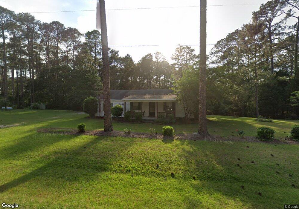
4333 Ga Highway 125 N Tifton, GA 31794
Estimated Value: $146,000 - $272,000
3
Beds
1
Bath
1,372
Sq Ft
$148/Sq Ft
Est. Value
About This Home
This home is located at 4333 Ga Highway 125 N, Tifton, GA 31794 and is currently estimated at $203,520, approximately $148 per square foot. 4333 Ga Highway 125 N is a home located in Tift County with nearby schools including Len Lastinger Primary School, Matt Wilson Elementary School, and J.T. Reddick School.
Ownership History
Date
Name
Owned For
Owner Type
Purchase Details
Closed on
Nov 17, 2008
Sold by
Sunsweet Investments Inc
Bought by
First Community Bank Of Tifton
Current Estimated Value
Purchase Details
Closed on
Jun 1, 2004
Sold by
Kratzer Wayne and Kratzer Betty
Bought by
Scott Stephen David and Etta Lynn
Purchase Details
Closed on
Nov 20, 1984
Sold by
Stinnett Walter Mitchell
Bought by
Stinnett Thelma M
Purchase Details
Closed on
Feb 17, 1983
Sold by
Dororhy Mitchell T and Dororhy Keith
Bought by
Stinnett Walter W and Stinnett Thelma M
Create a Home Valuation Report for This Property
The Home Valuation Report is an in-depth analysis detailing your home's value as well as a comparison with similar homes in the area
Home Values in the Area
Average Home Value in this Area
Purchase History
| Date | Buyer | Sale Price | Title Company |
|---|---|---|---|
| First Community Bank Of Tifton | -- | -- | |
| Scott Stephen David | $60,000 | -- | |
| Stinnett Thelma M | $21,000 | -- | |
| Stinnett Walter W | -- | -- |
Source: Public Records
Tax History Compared to Growth
Tax History
| Year | Tax Paid | Tax Assessment Tax Assessment Total Assessment is a certain percentage of the fair market value that is determined by local assessors to be the total taxable value of land and additions on the property. | Land | Improvement |
|---|---|---|---|---|
| 2024 | $1,060 | $44,714 | $4,402 | $40,312 |
| 2023 | $1,060 | $22,394 | $2,890 | $19,504 |
| 2022 | $665 | $22,394 | $2,890 | $19,504 |
| 2021 | $669 | $22,394 | $2,890 | $19,504 |
| 2020 | $681 | $22,394 | $2,890 | $19,504 |
| 2019 | $680 | $22,394 | $2,890 | $19,504 |
| 2018 | $679 | $22,394 | $2,890 | $19,504 |
| 2017 | $682 | $22,394 | $2,890 | $19,504 |
| 2016 | $580 | $22,394 | $2,890 | $19,504 |
| 2015 | $765 | $25,080 | $2,890 | $22,190 |
| 2014 | $767 | $25,080 | $2,890 | $22,190 |
| 2013 | -- | $25,080 | $2,890 | $22,190 |
Source: Public Records
Map
Nearby Homes
- 100 Long Pine Rd
- 142 Brighton Rd
- 7006 Northgate Dr
- 7013 Northgate Dr
- 0 Brighton Rd
- 87 Waterfront St Unit 9
- 87 Waterfront St
- 346 Somers Ln
- 4620 Murray Ave
- 0 E 46th St
- 913 E 46th St
- 717 E 44th St
- 4204 Lakeview Dr
- 50 Margaret Ln
- 714 44th St E
- 0 44th St E
- 903 42nd St E
- 0 Orchard Cir Unit 138472
- 126 Brownlee Cir
- 0 Belflower Rd Unit 24022932
- 4325 Ga Highway 125 N
- 4343 Ga Highway 125 N
- 235 Brighton Rd
- 4347 Ga Highway 125 N
- 4311 Ga Highway 125 N
- 4361 Ga Highway 125 N
- 4305 Ga Highway 125 N
- 4299 Ga Highway 125 N
- 212 Brighton Rd
- 4371 Ga Highway 125 N
- 31 Long Pine Rd
- 286 Brighton Rd
- 195 Brighton Rd
- 290 Brighton Rd
- 4286 Ga Highway 125 N
- 7 Long Pine Rd
- 35 Matthews Rd
- 298 Brighton Rd
- 4393 Ga Highway 125 N
- 36 Long Pine Rd