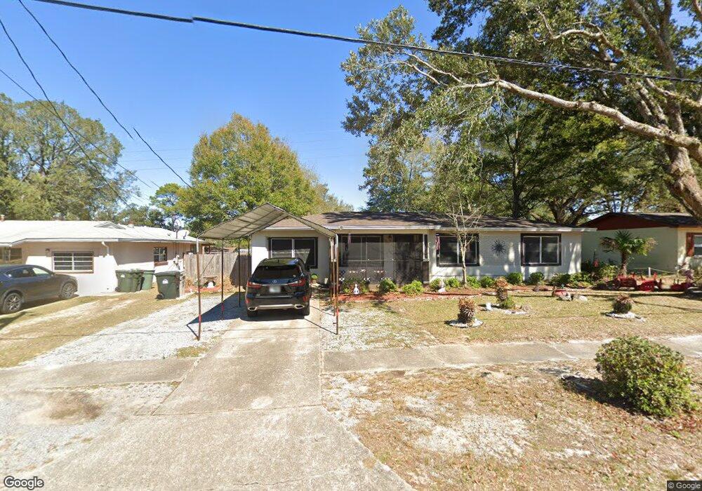
4334 Bridgedale Rd Pensacola, FL 32505
Estimated Value: $117,411 - $155,000
--
Bed
1
Bath
1,066
Sq Ft
$131/Sq Ft
Est. Value
About This Home
This home is located at 4334 Bridgedale Rd, Pensacola, FL 32505 and is currently estimated at $139,353, approximately $130 per square foot. 4334 Bridgedale Rd is a home located in Escambia County with nearby schools including Oakcrest Elementary School, Warrington Middle School, and Escambia High School.
Ownership History
Date
Name
Owned For
Owner Type
Purchase Details
Closed on
Jul 17, 2020
Sold by
Dawson Marcus R
Bought by
Dawson Carol L
Current Estimated Value
Purchase Details
Closed on
Jun 14, 2011
Sold by
Faddis Edwin Noel and Faddis Joanne
Bought by
Dawson Marcus R and Dawson Carol L
Home Financials for this Owner
Home Financials are based on the most recent Mortgage that was taken out on this home.
Original Mortgage
$48,300
Interest Rate
4.5%
Mortgage Type
Unknown
Purchase Details
Closed on
Feb 7, 2000
Sold by
Faddis Edwin Noel and Faddis Joanne G
Bought by
Faddis Edwin Noel
Create a Home Valuation Report for This Property
The Home Valuation Report is an in-depth analysis detailing your home's value as well as a comparison with similar homes in the area
Home Values in the Area
Average Home Value in this Area
Purchase History
| Date | Buyer | Sale Price | Title Company |
|---|---|---|---|
| Dawson Carol L | -- | None Available | |
| Dawson Marcus R | $48,300 | Emerald Coast Title Inc | |
| Faddis Edwin Noel | -- | -- |
Source: Public Records
Mortgage History
| Date | Status | Borrower | Loan Amount |
|---|---|---|---|
| Closed | Dawson Marcus R | $48,300 |
Source: Public Records
Tax History Compared to Growth
Tax History
| Year | Tax Paid | Tax Assessment Tax Assessment Total Assessment is a certain percentage of the fair market value that is determined by local assessors to be the total taxable value of land and additions on the property. | Land | Improvement |
|---|---|---|---|---|
| 2024 | $287 | $35,833 | -- | -- |
| 2023 | $287 | $34,790 | $0 | $0 |
| 2022 | $275 | $33,777 | $0 | $0 |
| 2021 | $262 | $32,794 | $0 | $0 |
| 2020 | $268 | $32,342 | $0 | $0 |
| 2019 | $259 | $31,615 | $0 | $0 |
| 2018 | $250 | $31,026 | $0 | $0 |
| 2017 | $244 | $30,388 | $0 | $0 |
| 2016 | $331 | $36,465 | $0 | $0 |
| 2015 | $311 | $36,676 | $0 | $0 |
| 2014 | $294 | $36,385 | $0 | $0 |
Source: Public Records
Map
Nearby Homes
- 6001 Toulouse Dr
- 1414 Clio Dr
- 305 N Madison Dr
- 1005 Revere Dr
- 1309 Belair Rd
- 1014 Kearny Dr
- 206 Garfield Dr
- 2077 Tujaques Place
- 1201 Belair Rd
- 1020 E Madison Dr
- 814 S Madison Dr
- 823 S Madison Dr
- 835 S Madison Dr
- 837 S Madison Dr
- 901 S Madison Dr
- 4407 Havre Way
- 7036 Rampart Way
- 4511 Saint Nazaire Rd
- 3236 Two Sisters Way
- 107 W Madison Dr
- 4336 Bridgedale Rd
- 4332 Bridgedale Rd
- 4330 Bridgedale Rd
- 4338 Bridgedale Rd
- 215 Cushman St
- 219 Cushman St
- 213 Cushman St
- 200 Algiers St
- 4333 Bridgedale Rd
- 221 Cushman St
- 4335 Bridgedale Rd
- 4340 Bridgedale Rd
- 4328 Bridgedale Rd
- 4331 Bridgedale Rd
- 2093 Massachusetts Ave
- 203 Algiers St
- 2097 Massachusetts Ave
- 4324 Bridgedale Rd
- 4329 Bridgedale Rd
- 209 Cushman St