Estimated Value: $213,000 - $233,000
3
Beds
3
Baths
1,738
Sq Ft
$126/Sq Ft
Est. Value
About This Home
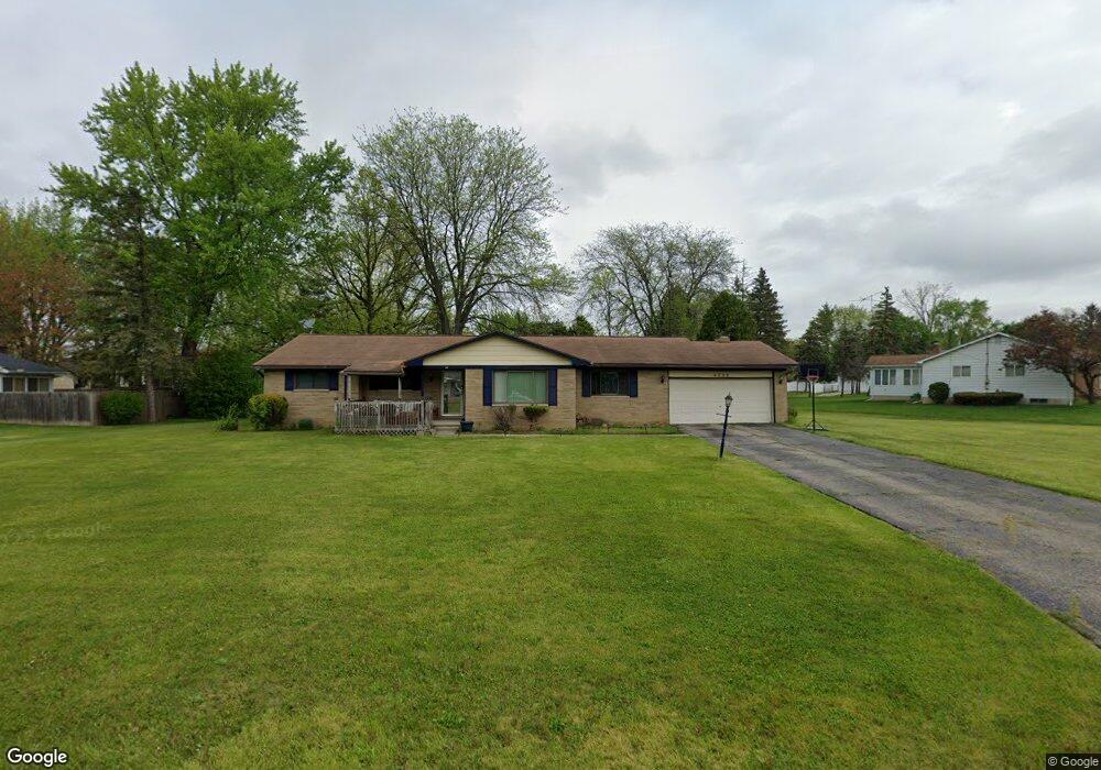
This home is located at 4336 Post Dr, Flint, MI 48532 and is currently estimated at $219,075, approximately $126 per square foot. 4336 Post Dr is a home located in Genesee County with nearby schools including Carman-Ainsworth High School, Genesee STEM Academy, and Linden Charter Academy.
Ownership History
Date
Name
Owned For
Owner Type
Purchase Details
Closed on
Sep 12, 2005
Sold by
Fannie Mae
Bought by
Pittman Donald E and Rawls Dellesa
Current Estimated Value
Purchase Details
Closed on
Jul 30, 2004
Sold by
Washington Mutual Bank Fa
Bought by
Federal National Mortgage Association
Purchase Details
Closed on
Jun 9, 2004
Sold by
Cobbin Floyd E and Cobbin Willie E
Bought by
Washington Mutual Bank Fa
Purchase Details
Closed on
Aug 27, 1999
Sold by
Pendell Carl T and Pendell Dorothy J
Bought by
Cobbin Floyd E and Cobbin Willie E
Create a Home Valuation Report for This Property
The Home Valuation Report is an in-depth analysis detailing your home's value as well as a comparison with similar homes in the area
Home Values in the Area
Average Home Value in this Area
Purchase History
| Date | Buyer | Sale Price | Title Company |
|---|---|---|---|
| Pittman Donald E | $145,000 | First American Title Ins Co | |
| Federal National Mortgage Association | -- | -- | |
| Washington Mutual Bank Fa | $114,621 | -- | |
| Cobbin Floyd E | $143,000 | Sargents Title Company Llc |
Source: Public Records
Tax History
| Year | Tax Paid | Tax Assessment Tax Assessment Total Assessment is a certain percentage of the fair market value that is determined by local assessors to be the total taxable value of land and additions on the property. | Land | Improvement |
|---|---|---|---|---|
| 2025 | $4,052 | $97,900 | $0 | $0 |
| 2024 | $1,451 | $94,900 | $0 | $0 |
| 2023 | $1,396 | $88,300 | $0 | $0 |
| 2022 | $1,370 | $81,100 | $0 | $0 |
| 2021 | $2,662 | $75,300 | $0 | $0 |
| 2020 | $1,347 | $63,100 | $0 | $0 |
| 2019 | $1,331 | $58,800 | $0 | $0 |
| 2018 | $2,566 | $58,800 | $0 | $0 |
| 2017 | $2,686 | $58,800 | $0 | $0 |
| 2016 | $2,524 | $51,200 | $0 | $0 |
| 2015 | $1,868 | $48,800 | $0 | $0 |
| 2014 | $1,108 | $46,800 | $0 | $0 |
| 2012 | -- | $47,100 | $47,100 | $0 |
Source: Public Records
Map
Nearby Homes
- 1090 Cabot Dr
- 1396 Westerrace Dr
- 1401 Hillside Dr
- 000 Devenish Ln
- 5021 Forest Side Dr
- 1034 Normandy Terrace Dr
- 1246 Dyemeadow Ln
- 4022 Beecher Rd
- 2174 Mill Rd
- Graham Rd N Graham Rd
- 2 Charter Dr
- 1137 S Graham Rd
- 3528 Beecher Rd
- 0 Charter Dr Unit 50153638
- 4199 Sheraton Dr
- 1161 S Dye Rd
- 3.9 Acres W Court St
- 2064 Lavelle Rd
- 3360 Beecher Rd
- 3350 Beecher Rd
- 4310 Post Dr
- 4360 Post Dr
- 4291 Hall Mark Ct
- 4341 Post Dr
- 4309 Post Dr
- 4333 Post Dr
- 4366 Post Dr
- 4307 Post Dr
- 4371 Post Dr
- 4295 Hall Mark Ct
- 1224 Joal Dr
- 1224 Joal Dr
- 4288 Hall Mark Ct Unit Bldg-Unit
- 4288 Hall Mark Ct
- 4290 Hall Mark Ct
- 4211 Cayuga Trail Unit 25
- 4297 Post Dr
- 4383 Post Dr
- 4187 Cayuga Trail
- 4195 Cayuga Trail
Your Personal Tour Guide
Ask me questions while you tour the home.