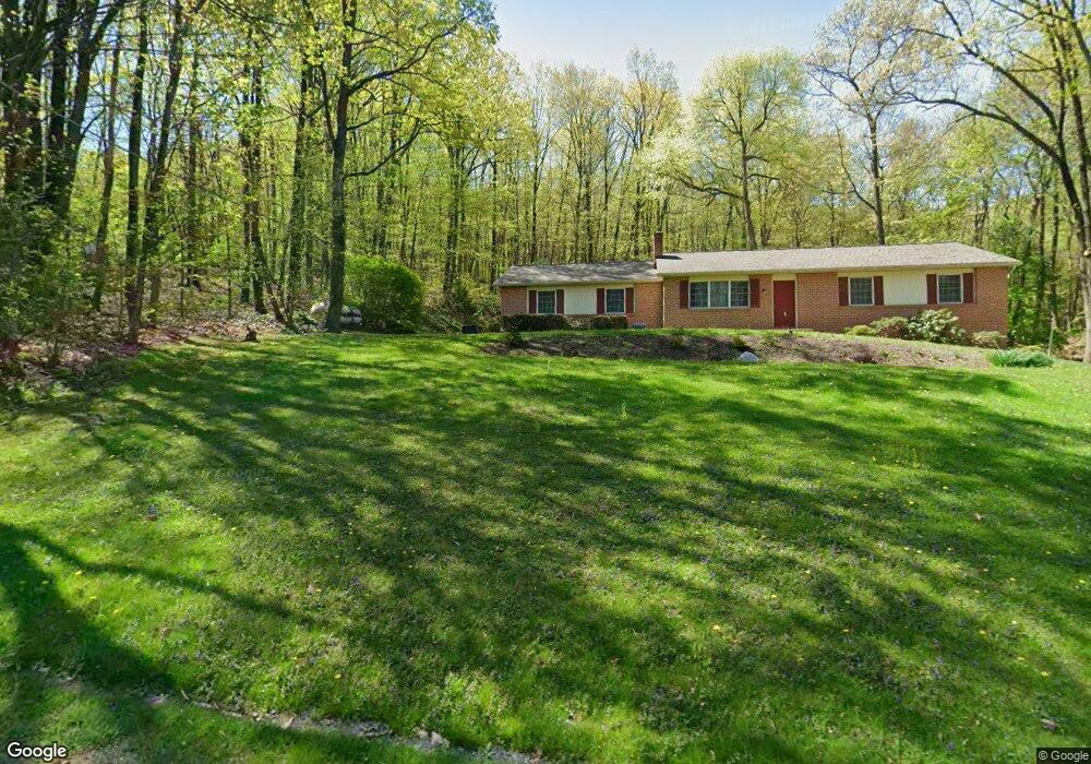
434 Shirktown Rd Narvon, PA 17555
Estimated Value: $362,000 - $404,000
3
Beds
3
Baths
1,232
Sq Ft
$316/Sq Ft
Est. Value
About This Home
This home is located at 434 Shirktown Rd, Narvon, PA 17555 and is currently estimated at $388,811, approximately $315 per square foot. 434 Shirktown Rd is a home located in Lancaster County with nearby schools including Garden Spot Middle School, Garden Spot Senior High School, and Conestoga Christian School.
Ownership History
Date
Name
Owned For
Owner Type
Purchase Details
Closed on
Nov 12, 2024
Sold by
Martin Joseph B and Hostetter Earl W
Bought by
Sweigart Jeffrey
Current Estimated Value
Home Financials for this Owner
Home Financials are based on the most recent Mortgage that was taken out on this home.
Original Mortgage
$240,000
Outstanding Balance
$237,593
Interest Rate
6.08%
Mortgage Type
New Conventional
Estimated Equity
$151,218
Create a Home Valuation Report for This Property
The Home Valuation Report is an in-depth analysis detailing your home's value as well as a comparison with similar homes in the area
Home Values in the Area
Average Home Value in this Area
Purchase History
| Date | Buyer | Sale Price | Title Company |
|---|---|---|---|
| Sweigart Jeffrey | $350,000 | None Listed On Document |
Source: Public Records
Mortgage History
| Date | Status | Borrower | Loan Amount |
|---|---|---|---|
| Open | Sweigart Jeffrey | $240,000 |
Source: Public Records
Tax History Compared to Growth
Tax History
| Year | Tax Paid | Tax Assessment Tax Assessment Total Assessment is a certain percentage of the fair market value that is determined by local assessors to be the total taxable value of land and additions on the property. | Land | Improvement |
|---|---|---|---|---|
| 2025 | $3,570 | $220,100 | $79,000 | $141,100 |
| 2024 | $3,570 | $220,100 | $79,000 | $141,100 |
| 2023 | $3,513 | $220,100 | $79,000 | $141,100 |
| 2022 | $3,472 | $220,100 | $79,000 | $141,100 |
| 2021 | $3,410 | $220,100 | $79,000 | $141,100 |
| 2020 | $3,410 | $220,100 | $79,000 | $141,100 |
| 2019 | $3,369 | $220,100 | $79,000 | $141,100 |
| 2018 | $5,324 | $220,100 | $79,000 | $141,100 |
| 2017 | $2,948 | $156,900 | $38,900 | $118,000 |
| 2016 | $2,948 | $156,900 | $38,900 | $118,000 |
| 2015 | $588 | $156,900 | $38,900 | $118,000 |
| 2014 | $2,197 | $156,900 | $38,900 | $118,000 |
Source: Public Records
Map
Nearby Homes
- 0 Westbrook Dr
- 0 Westbrook Dr
- 0 Westbrook Dr
- 0 Westbrook Dr
- 112 Maxwell Hill Rd
- 2085 Main St
- 110 Petrelia Dr
- 407 Cahill Cir Unit 4
- 1022 Elwood St
- 650 Broad St
- 1520 Lexington Way
- 1 Senn Ln
- 24 Wexford Ct
- 3511 Main St
- 44 Wexford Ct
- 102 Country Ln
- 607 Buchland Rd
- 0 Heritage Dr Unit 4A PABK2058798
- 0 Laurel Rd
- 5892 Meadville Rd
- 429 Shirktown Rd
- 433 Shirktown Rd
- 428 Shirktown Rd
- 421 Shirktown Rd
- 450 Shirktown Rd
- 417 Shirktown Rd
- 437 Shirktown Rd
- 449 Shirktown Rd
- 410 Shirktown Rd
- 409 Shirktown Rd
- 458 Shirktown Rd
- 407 Shirktown Rd
- 430 Shirktown Rd
- 462 Shirktown Rd
- 403 Shirktown Rd
- 59 Skyview Dr
- 400 Shirktown Rd
- 386 Shirktown Rd
- 393 Shirktown Rd
- 2552 Conestoga Creek Rd