Estimated Value: $388,000 - $452,000
3
Beds
3
Baths
1,415
Sq Ft
$293/Sq Ft
Est. Value
About This Home
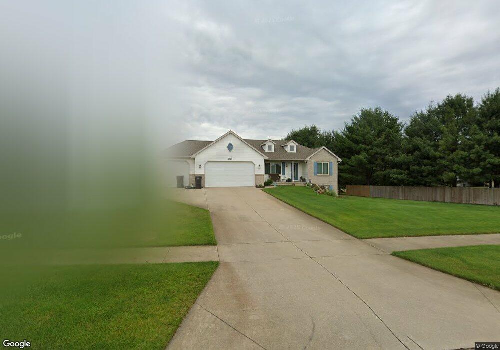
This home is located at 4348 Pheasant Run Dr, Dorr, MI 49323 and is currently estimated at $414,464, approximately $292 per square foot. 4348 Pheasant Run Dr is a home located in Allegan County with nearby schools including Wayland High School, Byron Center Charter School, and St. Stanislaus School.
Ownership History
Date
Name
Owned For
Owner Type
Purchase Details
Closed on
Apr 25, 2019
Sold by
Hawkins Matthew P and Hawkins Darcy J
Bought by
Hawkins Matthew P and Hawkins Darcy J
Current Estimated Value
Purchase Details
Closed on
Oct 29, 2001
Sold by
Keesee Jeffrey and Keesee Tracy L
Bought by
Hawkins Matthew P and Hawkins Darcy J
Home Financials for this Owner
Home Financials are based on the most recent Mortgage that was taken out on this home.
Original Mortgage
$62,000
Outstanding Balance
$24,233
Interest Rate
6.72%
Estimated Equity
$390,231
Purchase Details
Closed on
Mar 3, 2000
Bought by
Keesee Jeffrey and Keesee Tracy L
Purchase Details
Closed on
Jul 31, 1998
Sold by
Dykstra Karl W and Dykstra Linda E
Bought by
Pheasant Ridge Llc
Create a Home Valuation Report for This Property
The Home Valuation Report is an in-depth analysis detailing your home's value as well as a comparison with similar homes in the area
Home Values in the Area
Average Home Value in this Area
Purchase History
| Date | Buyer | Sale Price | Title Company |
|---|---|---|---|
| Hawkins Matthew P | -- | None Available | |
| Hawkins Matthew P | $172,900 | -- | |
| Keesee Jeffrey | $27,900 | -- | |
| Pheasant Ridge Llc | $215,000 | -- |
Source: Public Records
Mortgage History
| Date | Status | Borrower | Loan Amount |
|---|---|---|---|
| Open | Hawkins Matthew P | $62,000 |
Source: Public Records
Tax History
| Year | Tax Paid | Tax Assessment Tax Assessment Total Assessment is a certain percentage of the fair market value that is determined by local assessors to be the total taxable value of land and additions on the property. | Land | Improvement |
|---|---|---|---|---|
| 2025 | $3,194 | $196,700 | $64,200 | $132,500 |
| 2024 | $2,903 | $183,600 | $55,700 | $127,900 |
| 2023 | $2,974 | $161,400 | $51,200 | $110,200 |
| 2022 | $2,903 | $139,500 | $43,700 | $95,800 |
| 2021 | $2,731 | $137,100 | $45,500 | $91,600 |
| 2020 | $2,600 | $133,600 | $41,800 | $91,800 |
| 2019 | $2,600 | $121,200 | $41,800 | $79,400 |
| 2018 | $2,541 | $103,900 | $16,000 | $87,900 |
| 2017 | $0 | $106,600 | $16,000 | $90,600 |
| 2016 | $0 | $91,900 | $16,000 | $75,900 |
| 2015 | -- | $91,900 | $16,000 | $75,900 |
| 2014 | -- | $84,300 | $16,000 | $68,300 |
| 2013 | -- | $76,500 | $16,000 | $60,500 |
Source: Public Records
Map
Nearby Homes
- Lots A&B 142nd Ave
- 1341 142nd Ave
- 4069 21st St
- 4087 Gene Ct
- 4035 Patti Rd
- 10780 Windward Ave SW
- 10785 Windward Ave SW
- 10725 Windward Ave SW
- 10711 Windward Ave SW
- 4185 24th St
- 136 100th St SW
- 737 100th St SW
- 9705 Byron Center Ave SW
- 4335 Tavistock Dr
- Lot A 142nd Ave
- Lot B 142nd Ave
- 4230 Fenwick Dr
- 4316 Sussex Place
- 1125 Russell St
- 312 Ottogan Hills Ct
- 4344 Pheasant Run Dr
- 4340 Pheasant Run Dr
- 1848 144th Ave
- 1840 Quail Ridge Dr
- 4339 Pheasant Run Dr
- 1839 Quail Ridge Dr
- 4336 Pheasant Run Dr
- 1835 Quail Ridge Dr
- 1836 Quail Ridge Dr
- 4335 Pheasant Run Dr
- 4332 Pheasant Run Dr
- 4340 Quail Run Dr
- 4331 Pheasant Run Dr
- 1808 144th Ave
- 1802 144th Ave
- 4336 Quail Run Dr
- 1831 Quail Ridge Dr
- 4328 Pheasant Run Dr
- 1832 144th Ave
- 4341 Quail Run Dr
Your Personal Tour Guide
Ask me questions while you tour the home.