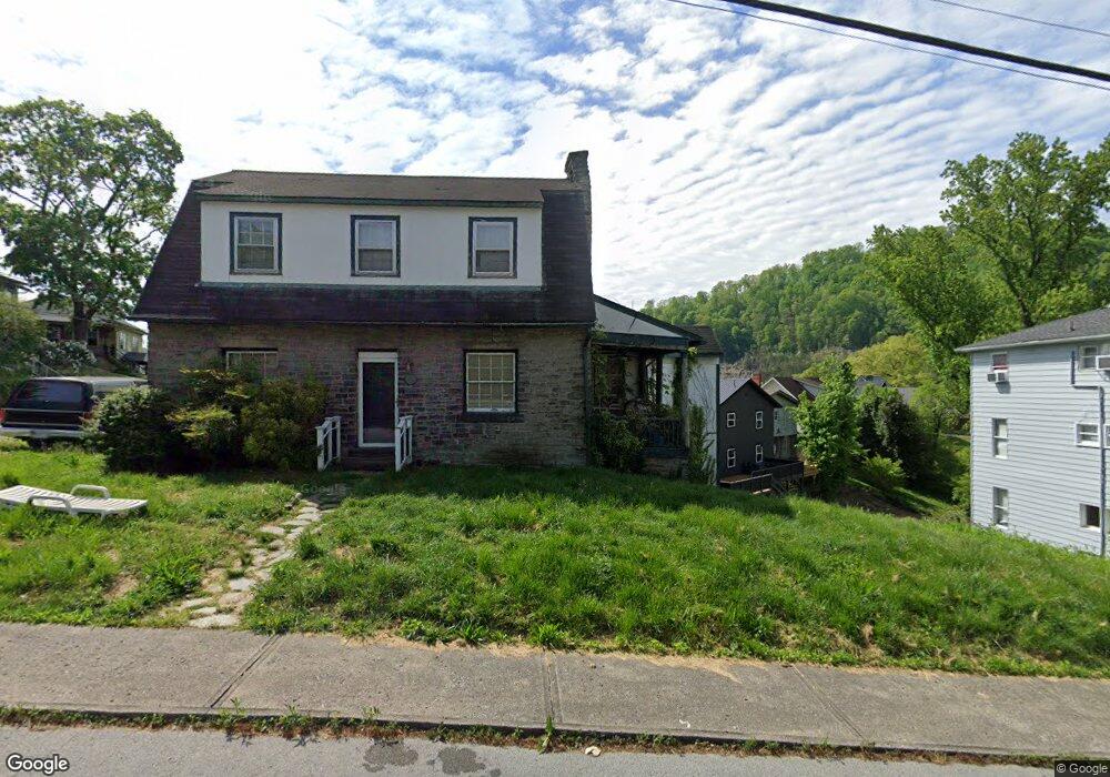
435 Baker Ave Hazard, KY 41701
Estimated Value: $72,000 - $157,684
4
Beds
2
Baths
2,004
Sq Ft
$64/Sq Ft
Est. Value
About This Home
This home is located at 435 Baker Ave, Hazard, KY 41701 and is currently estimated at $127,895, approximately $63 per square foot. 435 Baker Ave is a home with nearby schools including Roy G. Eversole Elementary School, Hazard Middle School, and Hazard High School.
Ownership History
Date
Name
Owned For
Owner Type
Purchase Details
Closed on
Sep 19, 2012
Sold by
Eversole Bryan
Bought by
Callahan Cheryl Teague and Eversole Cheryl
Current Estimated Value
Home Financials for this Owner
Home Financials are based on the most recent Mortgage that was taken out on this home.
Original Mortgage
$109,527
Outstanding Balance
$17,609
Interest Rate
3.71%
Estimated Equity
$110,286
Purchase Details
Closed on
Nov 20, 2008
Sold by
Kerns Margaret and Kerns John
Bought by
Eversole Bryan and Eversole Cheryl
Create a Home Valuation Report for This Property
The Home Valuation Report is an in-depth analysis detailing your home's value as well as a comparison with similar homes in the area
Home Values in the Area
Average Home Value in this Area
Purchase History
| Date | Buyer | Sale Price | Title Company |
|---|---|---|---|
| Callahan Cheryl Teague | -- | -- | |
| Eversole Bryan | $130,000 | -- |
Source: Public Records
Mortgage History
| Date | Status | Borrower | Loan Amount |
|---|---|---|---|
| Open | Callahan Cheryl Teague | $109,527 |
Source: Public Records
Tax History
| Year | Tax Paid | Tax Assessment Tax Assessment Total Assessment is a certain percentage of the fair market value that is determined by local assessors to be the total taxable value of land and additions on the property. | Land | Improvement |
|---|---|---|---|---|
| 2025 | $1,474 | $130,000 | $0 | $0 |
| 2024 | $1,474 | $130,000 | $0 | $0 |
| 2023 | $1,474 | $130,000 | $130,000 | $0 |
| 2022 | $1,442 | $130,000 | $130,000 | $0 |
| 2021 | $1,442 | $130,000 | $130,000 | $0 |
| 2020 | $1,439 | $130,000 | $130,000 | $0 |
| 2019 | $1,402 | $130,000 | $130,000 | $0 |
| 2018 | $1,357 | $130,000 | $130,000 | $0 |
| 2017 | $130,000 | $130,000 | $130,000 | $0 |
| 2016 | $130,000 | $130,000 | $130,000 | $0 |
| 2015 | $130,000 | $130,000 | $130,000 | $0 |
| 2013 | $1,257 | $130,000 | $130,000 | $0 |
Source: Public Records
Map
Nearby Homes
- 219 Perry Ave
- 309 Lyttle Blvd
- 164 Laurel St
- 270 Rockaway St
- 362 Poplar St
- 0 E Main St
- 141 Eversole St
- 148 Combs St
- 208 Eversole St
- 309 Locust St
- 540 Skyline Dr
- 1300 Kentucky Blvd
- 157 Alto St
- 2517 N Main St
- 272 Chimney Rock Rd
- 300 Perry Circle Rd
- 112 Cornett Hill Dr
- 48 Davis St
- 207 Cliff View Ln
- 215 Argyll Cir
- 601 Walnut St
- 501 Oakhurst Ave
- 501 Oakhurst Ave
- 376 Cornell St
- 500 Oakhurst Ave
- 360 Cornell Ave
- 600 Walnut St
- 600 Walnut St
- 409 Baker Ave
- 360 Cornell St
- 420 Baker Ave
- 369 Cornell Ave
- 508 Oakhurst Ave
- 508 Oakhurst Ave
- 716 Walnut St
- 352 Cornell Ave
- 361 Cornell Ave
- 724 Walnut St
- 800 Walnut St
- 216 Cornell Ave
Your Personal Tour Guide
Ask me questions while you tour the home.