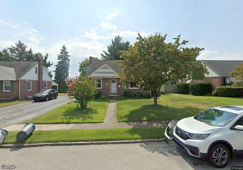
435 Barker Rd Springfield, PA 19064
Estimated Value: $500,000 - $554,000
4
Beds
3
Baths
2,464
Sq Ft
$217/Sq Ft
Est. Value
About This Home
This home is located at 435 Barker Rd, Springfield, PA 19064 and is currently estimated at $534,758, approximately $217 per square foot. 435 Barker Rd is a home located in Delaware County with nearby schools including Springfield High School and St Francis Of Assisi School.
Ownership History
Date
Name
Owned For
Owner Type
Purchase Details
Closed on
Sep 30, 1999
Sold by
Hanson Ann and Simpson Nancy C
Bought by
Deluca Robert L and Deluca Suzanne M
Current Estimated Value
Home Financials for this Owner
Home Financials are based on the most recent Mortgage that was taken out on this home.
Original Mortgage
$85,000
Interest Rate
7.46%
Mortgage Type
Purchase Money Mortgage
Create a Home Valuation Report for This Property
The Home Valuation Report is an in-depth analysis detailing your home's value as well as a comparison with similar homes in the area
Home Values in the Area
Average Home Value in this Area
Purchase History
| Date | Buyer | Sale Price | Title Company |
|---|---|---|---|
| Deluca Robert L | $135,000 | -- |
Source: Public Records
Mortgage History
| Date | Status | Borrower | Loan Amount |
|---|---|---|---|
| Closed | Deluca Robert L | $85,000 |
Source: Public Records
Tax History
| Year | Tax Paid | Tax Assessment Tax Assessment Total Assessment is a certain percentage of the fair market value that is determined by local assessors to be the total taxable value of land and additions on the property. | Land | Improvement |
|---|---|---|---|---|
| 2025 | $8,807 | $313,330 | $95,130 | $218,200 |
| 2024 | $8,807 | $313,330 | $95,130 | $218,200 |
| 2023 | $8,480 | $313,330 | $95,130 | $218,200 |
| 2022 | $8,297 | $313,330 | $95,130 | $218,200 |
| 2021 | $12,849 | $313,330 | $95,130 | $218,200 |
| 2020 | $7,858 | $173,420 | $45,730 | $127,690 |
| 2019 | $7,674 | $173,420 | $45,730 | $127,690 |
| 2018 | $7,564 | $173,420 | $0 | $0 |
| 2017 | $7,389 | $173,420 | $0 | $0 |
| 2016 | $952 | $173,420 | $0 | $0 |
| 2015 | $952 | $173,420 | $0 | $0 |
| 2014 | $952 | $173,420 | $0 | $0 |
Source: Public Records
Map
Nearby Homes
- 493 Wheatsheaf Rd
- 227 E Leamy Ave
- 332 Franklin Ave
- 364 S Rolling Rd
- 933 Greenbriar Ln
- 31 Wayfield Rd
- 226 Lynbrooke Rd
- 246 Pennington Ave
- 978 Westfield Rd
- 1299 Country Club Dr Unit Q141
- 507 School St
- 1291 Country Club Dr Unit Q137
- 1433 Country Club Dr Unit T214
- 111 Broad St
- 111 Forest Rd
- 7 & 0 Woodland Ave
- 173 Rambling Way
- 2 Yale Ave
- 211 S Norwinden Dr
- 1588 Nicklaus Dr Unit H65
- 429 Barker Rd
- 439 Barker Rd
- 425 Barker Rd
- 445 Barker Rd
- 432 Barker Rd
- 438 Barker Rd
- 452 Granite Terrace
- 419 Barker Rd
- 451 Barker Rd
- 426 Barker Rd
- 444 Barker Rd
- 400 Barker Rd
- 456 Granite Terrace
- 420 Barker Rd
- 450 Barker Rd
- 448 Granite Terrace
- 444 Granite Terrace
- 415 Barker Rd
- 455 Barker Rd
- 439 Thatcher Rd
Your Personal Tour Guide
Ask me questions while you tour the home.