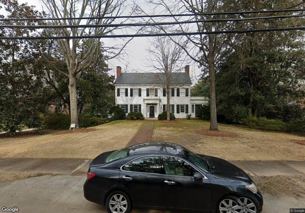
435 E College St Griffin, GA 30224
Spalding County NeighborhoodEstimated Value: $506,969 - $584,000
4
Beds
5
Baths
4,368
Sq Ft
$128/Sq Ft
Est. Value
About This Home
This home is located at 435 E College St, Griffin, GA 30224 and is currently estimated at $559,242, approximately $128 per square foot. 435 E College St is a home located in Spalding County with nearby schools including Futral Road Elementary School, Rehoboth Road Middle School, and Spalding High School.
Ownership History
Date
Name
Owned For
Owner Type
Purchase Details
Closed on
Nov 18, 2020
Sold by
Fortune Janice Cooper
Bought by
Fortune James R
Current Estimated Value
Purchase Details
Closed on
Mar 20, 1990
Sold by
Cheatham Elizabeth Mathis
Bought by
Fortune James R and Janice Ann
Purchase Details
Closed on
Jul 2, 1986
Sold by
Cheatham John Mcgee
Bought by
Cheatham Elizabeth Mathis
Purchase Details
Closed on
May 20, 1946
Bought by
Cheatham John Mcgee
Create a Home Valuation Report for This Property
The Home Valuation Report is an in-depth analysis detailing your home's value as well as a comparison with similar homes in the area
Home Values in the Area
Average Home Value in this Area
Purchase History
| Date | Buyer | Sale Price | Title Company |
|---|---|---|---|
| Fortune James R | -- | -- | |
| Fortune James R | $275,000 | -- | |
| Cheatham Elizabeth Mathis | -- | -- | |
| Cheatham John Mcgee | -- | -- |
Source: Public Records
Tax History Compared to Growth
Tax History
| Year | Tax Paid | Tax Assessment Tax Assessment Total Assessment is a certain percentage of the fair market value that is determined by local assessors to be the total taxable value of land and additions on the property. | Land | Improvement |
|---|---|---|---|---|
| 2024 | $5,522 | $193,205 | $32,200 | $161,005 |
| 2023 | $5,784 | $193,205 | $32,200 | $161,005 |
| 2022 | $4,751 | $148,016 | $27,600 | $120,416 |
| 2021 | $4,695 | $146,334 | $27,600 | $118,734 |
| 2020 | $4,701 | $146,334 | $27,600 | $118,734 |
| 2019 | $4,104 | $117,506 | $28,800 | $88,706 |
| 2018 | $0 | $111,426 | $28,800 | $82,626 |
| 2017 | $4,180 | $111,426 | $28,800 | $82,626 |
| 2016 | $3,968 | $104,804 | $28,800 | $76,004 |
| 2015 | $4,031 | $104,804 | $28,800 | $76,004 |
| 2014 | $4,144 | $104,804 | $28,800 | $76,004 |
Source: Public Records
Map
Nearby Homes
- 18 Terracedale Ct
- 40 Terrace St
- 304 Tilney Ave
- 523 S 6th St
- 541 S 6th St
- 550 S Hill St
- 406 E Solomon St
- 134 Townsend Ct
- 706 Maple Dr
- 650 S Hill St
- 714 Maple Dr
- 818 Hillcrest Ave
- 115 Kennelsman Dr Unit LOT FC 1
- 505 Kincaid Ave
- 102 N Hill St Unit 304
- 102 N Hill St Unit 303
- 303 E Broadway St
- 203 N 1st St
- 524 Kincaid Ave
- 234 N 2nd St
- 427 E College St
- 451 E College St
- 421 E College St
- 0 Brook Ln Unit 3211712
- 0 Brook Ln Unit 8422066
- 0 Brook Ln Unit 8077614
- 0 Brook Ln Unit 7531522
- 0 Brook Ln Unit 7356169
- 0 Brook Ln Unit 8959977
- 0 Brook Ln
- 417 E College St
- 503 E College St
- 522 Brook Cir
- 434 E College St
- 524 Brook Cir Unit 16
- 524 Brook Cir
- 509 E College St Unit 2
- 509 E College St
- 432 Brook Ln
- 440 Brook Ln