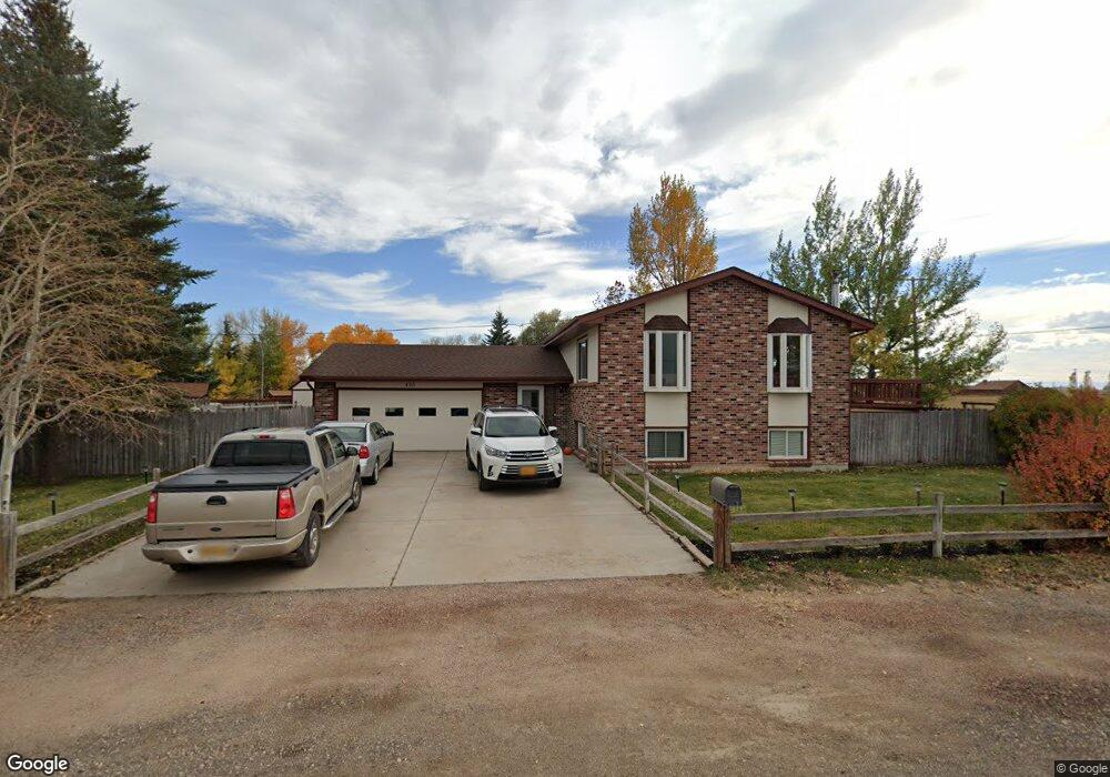
435 Eberhart St Laramie, WY 82070
Estimated Value: $368,000 - $406,000
3
Beds
2
Baths
1,032
Sq Ft
$368/Sq Ft
Est. Value
About This Home
This home is located at 435 Eberhart St, Laramie, WY 82070 and is currently estimated at $379,302, approximately $367 per square foot. 435 Eberhart St is a home located in Albany County with nearby schools including Velma Linford Elementary School, Laramie Middle School, and Laramie High School.
Ownership History
Date
Name
Owned For
Owner Type
Purchase Details
Closed on
Jun 1, 2023
Sold by
Dowie Nicholas John and Dowie Amber Robertson
Bought by
Ellis Elijah A
Current Estimated Value
Home Financials for this Owner
Home Financials are based on the most recent Mortgage that was taken out on this home.
Original Mortgage
$348,750
Outstanding Balance
$339,424
Interest Rate
6.39%
Mortgage Type
New Conventional
Estimated Equity
$39,878
Purchase Details
Closed on
Dec 17, 2008
Sold by
Yeend Jerry and Yeend Jacqueline A
Bought by
Dowie Nicholas John and Dowie Amber Robertson
Home Financials for this Owner
Home Financials are based on the most recent Mortgage that was taken out on this home.
Original Mortgage
$185,250
Interest Rate
6.19%
Mortgage Type
New Conventional
Create a Home Valuation Report for This Property
The Home Valuation Report is an in-depth analysis detailing your home's value as well as a comparison with similar homes in the area
Home Values in the Area
Average Home Value in this Area
Purchase History
| Date | Buyer | Sale Price | Title Company |
|---|---|---|---|
| Ellis Elijah A | -- | None Listed On Document | |
| Dowie Nicholas John | -- | -- |
Source: Public Records
Mortgage History
| Date | Status | Borrower | Loan Amount |
|---|---|---|---|
| Open | Ellis Elijah A | $348,750 | |
| Previous Owner | Dowie Nicholas John | $185,250 |
Source: Public Records
Tax History Compared to Growth
Tax History
| Year | Tax Paid | Tax Assessment Tax Assessment Total Assessment is a certain percentage of the fair market value that is determined by local assessors to be the total taxable value of land and additions on the property. | Land | Improvement |
|---|---|---|---|---|
| 2025 | $2,413 | $25,778 | $3,572 | $22,206 |
| 2024 | $2,413 | $33,048 | $4,579 | $28,469 |
| 2023 | $2,237 | $30,642 | $4,579 | $26,063 |
| 2022 | $2,152 | $29,478 | $4,579 | $24,899 |
| 2021 | $1,860 | $25,485 | $4,018 | $21,467 |
| 2020 | $1,609 | $22,045 | $3,370 | $18,675 |
| 2019 | $1,500 | $20,543 | $3,370 | $17,173 |
| 2018 | $1,469 | $20,123 | $3,033 | $17,090 |
| 2017 | $1,388 | $19,019 | $3,033 | $15,986 |
| 2016 | $1,371 | $18,774 | $3,033 | $15,741 |
| 2015 | $1,409 | $19,307 | $3,033 | $16,274 |
| 2014 | $1,387 | $19,006 | $0 | $0 |
Source: Public Records
Map
Nearby Homes
- 416 Arthur St
- 8 Star Struck Ln
- 2756 Snowy Range Rd
- 541 S Johnson St
- 1012 A-B S Colorado Ave
- 2260 Franklin St Unit 27
- 2260 Franklin St Unit 38
- 627 S Colorado Ave
- 2166 W Wyoming Ave Unit 29
- 2166 W Wyoming Ave Unit 25
- TBD Wyoming 230
- 2075 Jefferson St
- 1416 S Colorado Ave
- 1412 S Colorado Ave
- 1414 S Colorado Ave
- 1410 S Colorado Ave
- 1990 Truman St
- 174 N Colorado Ave
- 370 S Buchanan St
- 1866 Truman St
- 431 Eberhart St
- 521 Schrader St
- 430 Eberhart St
- 427 Eberhart St
- 422 Eberhart St
- 2677 Jackson St
- 2673 Jackson St
- 515 Schrader St
- 423 Eberhart St
- 2669 Jackson St
- 418 Eberhart St
- 2665 Jackson St
- 2751 Jackson St
- 412 Eberhart St
- 2661 Jackson St
- 417 Eberhart St
- 2657 Jackson St
- 402 Eberhart St
- 413 Eberhart St
- 2678 Dadisman St