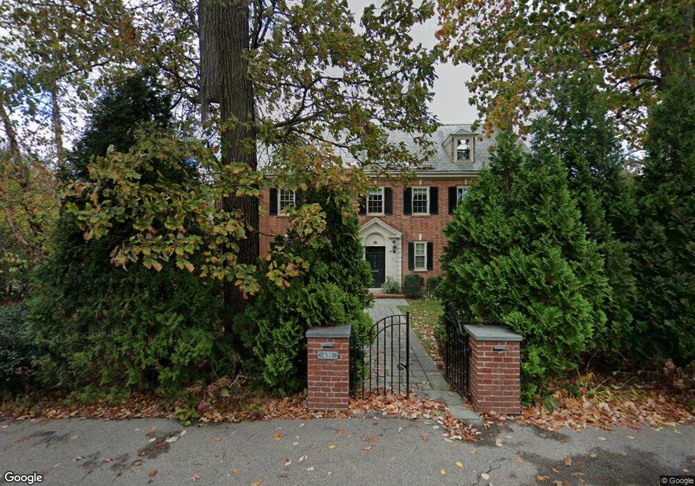
435 Heath St Chestnut Hill, MA 02467
Chestnut Hill NeighborhoodEstimated Value: $4,205,473 - $5,077,000
9
Beds
6
Baths
5,395
Sq Ft
$886/Sq Ft
Est. Value
About This Home
This home is located at 435 Heath St, Chestnut Hill, MA 02467 and is currently estimated at $4,782,158, approximately $886 per square foot. 435 Heath St is a home located in Norfolk County with nearby schools including Heath Elementary School, Brookline High School, and Mount Alvernia Academy.
Ownership History
Date
Name
Owned For
Owner Type
Purchase Details
Closed on
Oct 26, 2011
Sold by
Boardman Cynthia R and Boardman Samuel Jm
Bought by
Dhir Atul and Dhir G
Current Estimated Value
Home Financials for this Owner
Home Financials are based on the most recent Mortgage that was taken out on this home.
Original Mortgage
$1,500,000
Outstanding Balance
$971,199
Interest Rate
3%
Mortgage Type
Purchase Money Mortgage
Estimated Equity
$3,810,959
Create a Home Valuation Report for This Property
The Home Valuation Report is an in-depth analysis detailing your home's value as well as a comparison with similar homes in the area
Home Values in the Area
Average Home Value in this Area
Purchase History
| Date | Buyer | Sale Price | Title Company |
|---|---|---|---|
| Dhir Atul | $2,571,000 | -- |
Source: Public Records
Mortgage History
| Date | Status | Borrower | Loan Amount |
|---|---|---|---|
| Open | Dhir Atul | $1,500,000 |
Source: Public Records
Tax History
| Year | Tax Paid | Tax Assessment Tax Assessment Total Assessment is a certain percentage of the fair market value that is determined by local assessors to be the total taxable value of land and additions on the property. | Land | Improvement |
|---|---|---|---|---|
| 2025 | $45,293 | $4,589,000 | $1,786,900 | $2,802,100 |
| 2024 | $43,301 | $4,432,000 | $1,718,200 | $2,713,800 |
| 2023 | $40,244 | $4,036,500 | $1,432,000 | $2,604,500 |
| 2022 | $39,173 | $3,844,300 | $1,363,800 | $2,480,500 |
| 2021 | $36,225 | $3,696,400 | $1,311,300 | $2,385,100 |
| 2020 | $33,527 | $3,547,800 | $1,192,100 | $2,355,700 |
| 2019 | $31,659 | $3,378,800 | $1,135,300 | $2,243,500 |
| 2018 | $31,931 | $3,375,400 | $1,199,000 | $2,176,400 |
| 2017 | $31,461 | $3,184,300 | $1,131,200 | $2,053,100 |
| 2016 | $31,010 | $2,976,000 | $1,057,200 | $1,918,800 |
| 2015 | $29,704 | $2,781,300 | $988,000 | $1,793,300 |
| 2014 | $30,776 | $2,702,000 | $898,100 | $1,803,900 |
Source: Public Records
Map
Nearby Homes
- 476 Heath St
- 460 Heath St
- 1014 Boylston St
- 331 Heath St
- 0 Glenoe Rd
- 3 Glenoe Rd
- 130 Cabot St
- 764 Hammond St
- 9 Singletree Rd
- 142 Crafts Rd
- 188 Heath St
- 394 Hammond St
- 76 Boylston St Unit 4
- 15 Glenland Rd
- 520 Clinton Rd
- 85 Gate House Rd
- 321 Hammond Pond Pkwy Unit 103
- 321 Hammond Pond Pkwy Unit 105
- 321 Hammond Pond Pkwy Unit 106
- 55 Reservoir Rd Unit 2
Your Personal Tour Guide
Ask me questions while you tour the home.