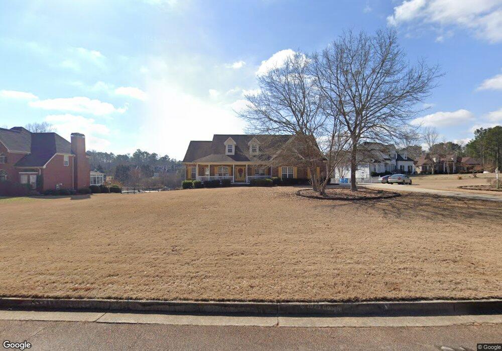
435 Lancelot Trail McDonough, GA 30252
Estimated Value: $411,335 - $479,000
4
Beds
3
Baths
3,027
Sq Ft
$146/Sq Ft
Est. Value
About This Home
This home is located at 435 Lancelot Trail, McDonough, GA 30252 and is currently estimated at $441,584, approximately $145 per square foot. 435 Lancelot Trail is a home located in Henry County with nearby schools including Tussahaw Elementary School, Locust Grove Middle School, and Locust Grove High School.
Ownership History
Date
Name
Owned For
Owner Type
Purchase Details
Closed on
Jun 7, 2002
Sold by
Sunflower Prop Inc
Bought by
Cannon Ronnie E and Cannon Donna M
Current Estimated Value
Home Financials for this Owner
Home Financials are based on the most recent Mortgage that was taken out on this home.
Original Mortgage
$207,200
Outstanding Balance
$86,507
Interest Rate
6.77%
Mortgage Type
New Conventional
Estimated Equity
$355,077
Create a Home Valuation Report for This Property
The Home Valuation Report is an in-depth analysis detailing your home's value as well as a comparison with similar homes in the area
Home Values in the Area
Average Home Value in this Area
Purchase History
| Date | Buyer | Sale Price | Title Company |
|---|---|---|---|
| Cannon Ronnie E | $235,500 | -- |
Source: Public Records
Mortgage History
| Date | Status | Borrower | Loan Amount |
|---|---|---|---|
| Open | Cannon Ronnie E | $207,200 |
Source: Public Records
Tax History Compared to Growth
Tax History
| Year | Tax Paid | Tax Assessment Tax Assessment Total Assessment is a certain percentage of the fair market value that is determined by local assessors to be the total taxable value of land and additions on the property. | Land | Improvement |
|---|---|---|---|---|
| 2025 | $1,728 | $180,360 | $18,000 | $162,360 |
| 2024 | $1,728 | $181,040 | $18,000 | $163,040 |
| 2023 | $1,423 | $177,520 | $18,000 | $159,520 |
| 2022 | $1,554 | $158,040 | $18,000 | $140,040 |
| 2021 | $1,874 | $134,280 | $18,000 | $116,280 |
| 2020 | $1,749 | $129,040 | $14,800 | $114,240 |
| 2019 | $2,714 | $129,880 | $15,000 | $114,880 |
| 2018 | $1,996 | $104,600 | $10,800 | $93,800 |
| 2016 | $2,818 | $88,280 | $10,000 | $78,280 |
| 2015 | $2,891 | $87,920 | $8,000 | $79,920 |
| 2014 | $2,778 | $74,400 | $10,000 | $64,400 |
Source: Public Records
Map
Nearby Homes
- 103 Royal Way
- 224 Osier Dr
- 175 Osier Dr
- 450 Noblewood Dr
- 446 Noblewood Dr
- 435 Noblewood Dr
- 420 Tavistock Ct
- 168 Osier Dr
- 150 Whitaker Rd
- 1171 King Mill Rd
- 205 Calvery Way
- 0 Nail Mill Rd
- 308 Stallings Dr
- 0 King Mill Rd Unit 10647914
- 0 King Mill Rd Unit 7684355
- 9054 Dawes Crossing
- 435 Rabbit Run
- 201 Nina Cir
- 8008 Revere Dr Unit 1
- 150 Sterling Ave
- 437 Lancelot Trail
- 431 Lancelot Trail
- 440 Lancelot Trail
- 436 Lancelot Trail
- 441 Lancelot Trail
- 430 Lancelot Trail
- 447 Lancelot Trail
- 446 Lancelot Trail
- 426 Lancelot Trail
- 236 Arthur Dr
- 0 Lancelot Trail Unit 8457250
- 0 Lancelot Trail Unit 8377748
- 0 Lancelot Trail Unit 8820192
- 0 Lancelot Trail Unit 8205007
- 0 Lancelot Trail Unit 7559601
- 0 Lancelot Trail Unit 7436745
- 132 Brittany Ln Unit 2
- 230 Arthur Dr
- 424 Lancelot Trail
- 424 Lancelot Trail Unit /21