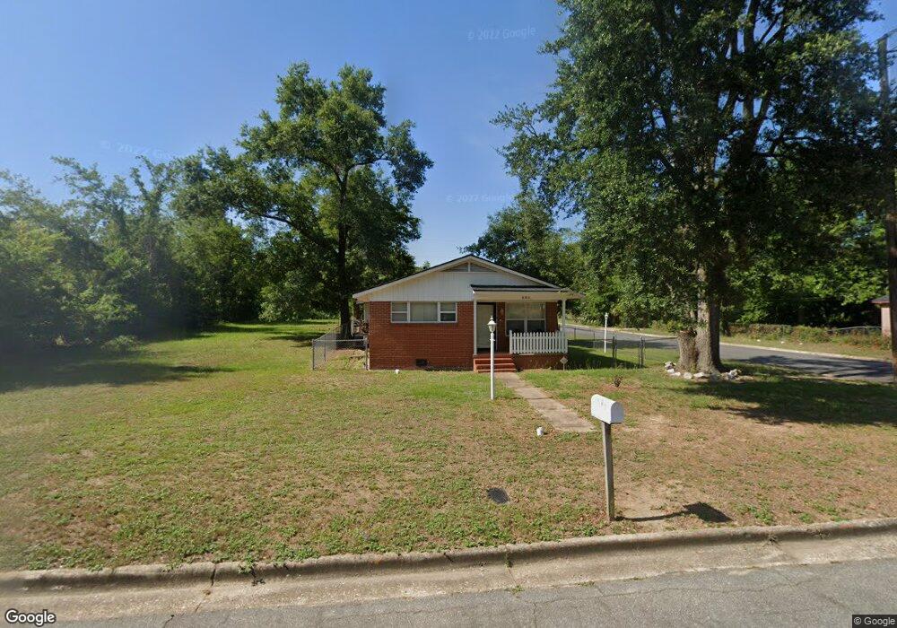
436 Dorsett Ave Albany, GA 31701
Ragsdale NeighborhoodEstimated Value: $61,095 - $78,000
4
Beds
2
Baths
992
Sq Ft
$69/Sq Ft
Est. Value
About This Home
This home is located at 436 Dorsett Ave, Albany, GA 31701 and is currently estimated at $68,774, approximately $69 per square foot. 436 Dorsett Ave is a home located in Dougherty County with nearby schools including Martin Luther King Jr. Elementary School, Southside Middle School, and Monroe High School.
Ownership History
Date
Name
Owned For
Owner Type
Purchase Details
Closed on
Jun 27, 2001
Sold by
Oxendine Ronnie
Bought by
Moses Belle
Current Estimated Value
Purchase Details
Closed on
Apr 27, 2000
Sold by
Chae Manhattan Bank Tr - Imc Home Equity
Bought by
Oxendine Ronnie W
Purchase Details
Closed on
Oct 4, 1999
Sold by
Imc Mortgage Co
Bought by
Chase Manhattan Bank - Imc Home Eq Ln Tr
Purchase Details
Closed on
Apr 7, 1999
Sold by
Collins Charles J & April N & R K By At
Bought by
Imc Mortgage Co
Purchase Details
Closed on
Jun 15, 1998
Sold by
Greyfield Resources Inc
Bought by
Collins Charles J Etal
Purchase Details
Closed on
Aug 5, 1997
Sold by
Collins Charles J Etal By City Marshall
Bought by
Greyfield Resources
Purchase Details
Closed on
Oct 28, 1994
Sold by
Collins Artealia Walker By Administrator
Bought by
Individually Collins Charles J
Purchase Details
Closed on
Aug 28, 1985
Sold by
Walker Isaac
Bought by
Collins Artealia W
Create a Home Valuation Report for This Property
The Home Valuation Report is an in-depth analysis detailing your home's value as well as a comparison with similar homes in the area
Home Values in the Area
Average Home Value in this Area
Purchase History
| Date | Buyer | Sale Price | Title Company |
|---|---|---|---|
| Moses Belle | $50,000 | -- | |
| Oxendine Ronnie W | $13,500 | -- | |
| Chase Manhattan Bank - Imc Home Eq Ln Tr | -- | -- | |
| Imc Mortgage Co | $38,800 | -- | |
| Collins Charles J Etal | -- | -- | |
| Greyfield Resources | -- | -- | |
| Individually Collins Charles J | -- | -- | |
| Collins Artealia W | -- | -- |
Source: Public Records
Tax History Compared to Growth
Tax History
| Year | Tax Paid | Tax Assessment Tax Assessment Total Assessment is a certain percentage of the fair market value that is determined by local assessors to be the total taxable value of land and additions on the property. | Land | Improvement |
|---|---|---|---|---|
| 2024 | $964 | $20,200 | $1,480 | $18,720 |
| 2023 | $941 | $20,200 | $1,480 | $18,720 |
| 2022 | $945 | $20,200 | $1,480 | $18,720 |
| 2021 | $876 | $20,200 | $1,480 | $18,720 |
| 2020 | $878 | $20,200 | $1,480 | $18,720 |
| 2019 | $881 | $20,200 | $1,480 | $18,720 |
| 2018 | $885 | $20,200 | $1,480 | $18,720 |
| 2017 | $824 | $20,200 | $1,480 | $18,720 |
| 2016 | $825 | $20,200 | $1,480 | $18,720 |
| 2015 | $827 | $20,200 | $1,480 | $18,720 |
| 2014 | $817 | $20,200 | $1,480 | $18,720 |
Source: Public Records
Map
Nearby Homes
- 512 Cherry Ave
- 604 Jefferies Ave
- 404 Cedar Ave
- 420 Cotton Ave
- 418 Cotton Ave
- 417 Cotton Ave
- 415 Cotton Ave
- 1505 Mcarthur St
- 600 W Lincoln Ave
- 612 Louis Ave
- 515 W Lincoln Ave
- 611 Albert Ct
- 526 W Mercer Ave
- 704 W Lincoln Ave
- 1627 Mcarthur St
- 2504 S Madison St
- 807 Corn Ave
- 607 Harmon Ave
- 418 Harmon Ave
- 705 W Mercer Ave