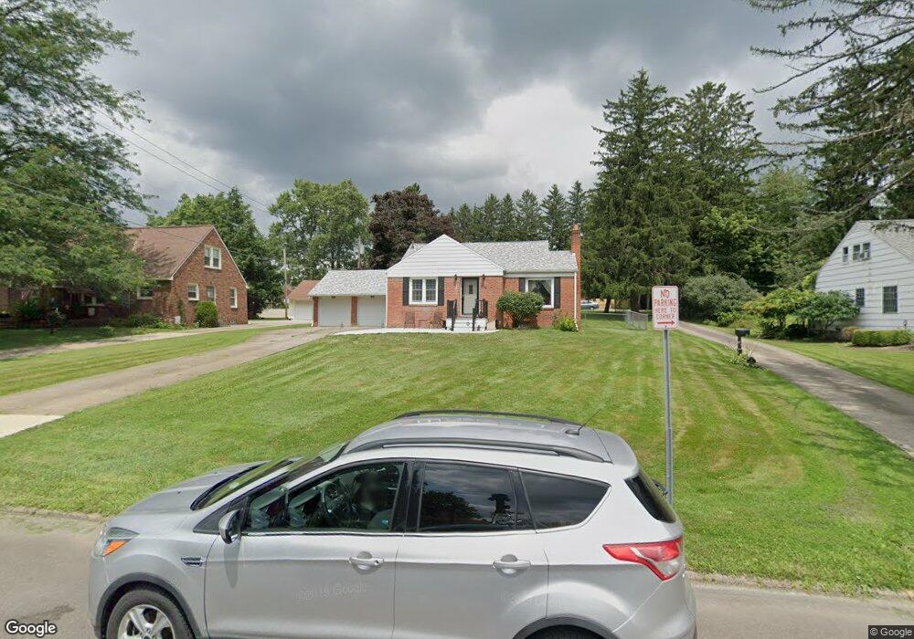
436 Stewart Ln Mansfield, OH 44907
Estimated Value: $169,312 - $189,000
2
Beds
1
Bath
1,169
Sq Ft
$152/Sq Ft
Est. Value
About This Home
This home is located at 436 Stewart Ln, Mansfield, OH 44907 and is currently estimated at $177,828, approximately $152 per square foot. 436 Stewart Ln is a home located in Richland County with nearby schools including Discovery School, St. Peter's Elementary/Montessori School, and St. Peter's High School/Junior High.
Ownership History
Date
Name
Owned For
Owner Type
Purchase Details
Closed on
Mar 15, 2002
Sold by
Haynes Colleen G
Bought by
Carver Janie J
Current Estimated Value
Purchase Details
Closed on
Jul 24, 1996
Sold by
Mccallister Robert L
Bought by
Haynes Colleen G and Murphy Juanita C
Create a Home Valuation Report for This Property
The Home Valuation Report is an in-depth analysis detailing your home's value as well as a comparison with similar homes in the area
Home Values in the Area
Average Home Value in this Area
Purchase History
| Date | Buyer | Sale Price | Title Company |
|---|---|---|---|
| Carver Janie J | $90,000 | -- | |
| Haynes Colleen G | $75,000 | -- |
Source: Public Records
Mortgage History
| Date | Status | Borrower | Loan Amount |
|---|---|---|---|
| Closed | Haynes Colleen G | $0 | |
| Closed | Carver Janie J | -- |
Source: Public Records
Tax History Compared to Growth
Tax History
| Year | Tax Paid | Tax Assessment Tax Assessment Total Assessment is a certain percentage of the fair market value that is determined by local assessors to be the total taxable value of land and additions on the property. | Land | Improvement |
|---|---|---|---|---|
| 2024 | $2,039 | $43,540 | $9,500 | $34,040 |
| 2023 | $2,039 | $43,540 | $9,500 | $34,040 |
| 2022 | $1,858 | $33,260 | $8,490 | $24,770 |
| 2021 | $1,871 | $33,260 | $8,490 | $24,770 |
| 2020 | $1,913 | $33,260 | $8,490 | $24,770 |
| 2019 | $1,797 | $28,190 | $7,200 | $20,990 |
| 2018 | $1,773 | $28,190 | $7,200 | $20,990 |
| 2017 | $1,725 | $28,190 | $7,200 | $20,990 |
| 2016 | $1,739 | $27,560 | $6,980 | $20,580 |
| 2015 | $1,661 | $27,560 | $6,980 | $20,580 |
| 2014 | $1,640 | $27,560 | $6,980 | $20,580 |
| 2012 | $644 | $28,410 | $7,200 | $21,210 |
Source: Public Records
Map
Nearby Homes
- 421 Edgewood Rd
- 0 George Ave
- 400 James Ave
- 431 Overlook Rd
- 589 Andover Rd
- 655 Woodhill Rd
- 1009 Woodhill Rd
- 501 Clifton Blvd
- 484 Beechwood Dr
- 181 Chilton Ave
- 1125 Larchwood Rd
- 179 Chilton Ave
- 220 W Cook Rd
- 654 Courtwright Blvd
- 505 Wood St
- 1156 Yorkwood Rd
- 0 U S Highway 42
- 0 Lexington Ave Unit 224009661
- 1179 Burkwood Rd
- 136 Elmridge Rd
- 440 Stewart Ln
- 426 Stewart Ln
- 446 Stewart Ln
- 432 Stewart Ln
- 420 Stewart Ln Unit 422
- 431 Stewart Ln Unit 433
- 750 Lexington Ave
- 460 Stewart Ln
- 710 Lexington Ave
- 429 Stewart Ln
- 429 Stewart Ln
- 795 Andover Rd
- 760 Lexington Ave
- 766 Lexington Ave
- 811 Andover Rd
- 423 Chevy Chase Rd
- 427 Chevy Chase Rd
- 791 Andover Rd
- 763 Yale Dr
- 779 Andover Rd